Quantcast

November Ponderings


Treehouse and crew, the early days

First of all, Sundance is taking a break. He had some business matters to handle. This blog started on February 1, 2011, and in all that time, except for when he was on his trip to meet with some contacts, and helping out after disasters, I remember Sundance taking off a few days only one time. He went on a fishing trip and left the gals in charge. We managed not to set the Treehouse on fire, and even resisted ordering new furniture and hanging pictures.

And so, here we are, still in the same Tree. (more…)

Could Be Interesting – Tucker Carlson Visits Julian Assange?

For a brief moment I will allow myself to imagine that Tucker Carlson’s research team is aware of the information we have previously provided.  If so, an interview with Julian Assange could be exceptionally interesting.

Tucker posts on Twitter that he was visiting with Julian Assange today:

[Source Link]

A WALK IN THE VERY DEEP WEEDS….

The Weissmann/Mueller report contains claims that Russia hacked the DNC servers as the central element to the Russia interference narrative in the U.S. election.  This DNC hack claim is the fulcrum issue structurally underpinning the Russian election interference narrative pushed by the Weissmann and Muller Special Counsel.  However, this essential claim is directly disputed by WikiLeaks founder Julian Assange, as outlined during a Dana Rohrabacher interview and by Julian Assange’s own on-the-record statements.

(more…)

When It Comes to U.S. Intelligence Community Claims, ie. Egypt Warning Israel, Apply Strong Cynicism

Apparently, some people have forgotten that American citizens are in an abusive relationship with our government.  A government that has demonstrably lied repeatedly and used the official institutions of the U.S. intelligence apparatus to do so [See reference of 50 former intel officials claiming Biden laptop was Russian disinformation].

So, allow me to walk through the process of the story attributed most recently to House Foreign Affairs Committee Chairman Mike McCaul, as relayed to him by DNI Avril Haines, an Obama operative inside the Biden administration, and broadcast to media.

McCaul claims the US Intelligence Community know that Egypt warned Israel of the pending Hamas attack.  Everything about this is sketchy in the extreme.  Senior Egyptian Intelligence officials state, without qualification, that such a warning never happened {link}, and Bibi Netanyahu has said it was fake news {link}.  I believe President Fattah Abdel al-Sisi and Prime Minister Netanyahu – here’s why.

First, don’t forget the geopolitical motives to disparage and diminish Egypt after they recently joined the BRICS economic alliance.

Second, don’t forget that following Obama and Clinton’s ill-fated attempt to install a Muslim Brotherhood leader in Egypt, Mohammed Morsi, General al-Sisi was forced to stop the Islamist Spring in Egypt.  That put Sisi on the opposite side of Obama, and years of manipulative disparagement ensued.   However, Sisi put his commitment to eradicating extremism -like Hamas- into action, not mere words {GO DEEP}.

In 2014, Sisi began destroying Hamas tunnels into Gaza from the Sinai region of Egypt.  {link} This was not a small task, as it was discovered that one-third of all buildings in the region contained tunnels into Gaza that were being used by Hamas terrorists. {link}  At the time, we called them al-Qaeda and ISIS, but they are all various factions of the extremist sentiment espoused by the Muslim Brotherhood.  Sisi kicked the Brotherhood out of Egypt {link}.  They fled to Qatar.

In retaliation, in early 2015 Hamas and the Muslim Brotherhood put a fatwah on al-Sisi and called for Jihad against Egypt {link}. Against the backdrop of the first border opening between Egypt’s northern Sinai and Gaza, and against the ongoing efforts by the al-Sisi led coalition to move toward peace between Arabs and Israelis, the extremists strike back in 2017 with a horrific terrorist attack against the Al Rawdah mosque in Bir al-Abed, west of El Arish, the main city in North Sinai. 235 people were killed and hundreds more wounded {link}

(more…)

A DC Cornerstone Issue That Must Be Understood – This Isn’t What You Learned on Schoolhouse Rock

I’m going to build out on this in the next several days and weeks.  The reason is simple, this is the cornerstone of DC Business; it has nothing to do with legislation, lawmaking, or the other reference points we retain in the illusion of modern politics.  It’s going to get ugly!

CTH often describes the background DC motives with the phrase: “There are Trillions at Stake.”  Here we take a look at what that really means, and how DC politics is not quite based on the ideas that frame many reference points.

With people taking notice of DC politics for the first time, and with people not as familiar with the purpose of DC politics, we end up within two different references. Perhaps it is valuable to reset the larger frames of reference and provide clarity.

I’ve been talking about this for well over a decade, and we have had this conversation on these pages for just as long. However, in this video Bill Gurley brings some modern receipts. WATCH: 

Most people think when they vote for a federal politician -a House or Senate representative- they are voting for a person who will go to Washington DC and write or enact legislation. This is the old-fashioned “schoolhouse rock” perspective based on decades past.  There is not a single person in Congress writing legislation or laws.

In modern politics, not a single member of the House of Representatives or Senator writes a law, or puts pen to paper to write out a legislative construct. This simply doesn’t happen.

Over the past several decades a system of constructing legislation has taken over Washington DC that more resembles a business operation than a legislative body.

Here’s how it works right now.

(more…)

East Coast U.S. – Keep Eye on Hurricane Lee, Expected to Become Major Slow Moving Hurricane Today, Still a Week Away

Hurricane Lee is moving slowly in the southern Atlantic approaching the Leeward Islands. [NHC DATA HERE] Residents on the Southeast coast of the USA should monitor. Lee is expected to become a major hurricane later tonight as it moves toward the west-northwest over the next few days.

Hurricane Lee is still a long distance from presenting any immediate risk, but prudent checks and evaluations of your situation should take place.  Keep an eye on the National Hurricane Center for updates.  The storm is not anticipated to be a major focus until mid-week next week.

At 1100 AM AST (1500 UTC), the center of Hurricane Lee was located near latitude 16.4 North, longitude 50.0 West. Lee is moving toward the west-northwest near 15 mph (24 km/h), and this motion is expected to continue through Friday. A slower motion toward the west-northwest is forecast over the weekend. On the forecast track,the core of Lee will move north of the northern Leeward islands during the next few days. (link)

Obviously, this is currently a long way from the eastern U.S.  However, coastal residents should keep an eye on Lee and evaluate their pre-existing preparedness plans.

(more…)

Hurricane Idalia Scheduled to Make Landfall in Florida Big Bend as Category-4 Storm

The time for preparations and/or evacuation decisions is past.  This is pure hunker down time right now.  Those in the immediate impact zone of Hurricane Idalia will see rapidly deteriorating weather conditions over the next few hours.  Landfall expected at sunrise Wednesday.

Idalia will remain at hurricane strength throughout Georgia and likely into South Carolina.  There will be a large swath of area impacted.  There will be power outages and severe disruptions in all three states throughout the day today.

At 200 AM EDT (0600 UTC), the center of Hurricane Idalia was located near latitude 28.3 North, longitude 84.5 West. Idalia is moving toward the north near 15 mph (24 km/h). A northward to north-northeastward motion is expected through morning, with Idalia’s center forecast to reach the Big Bend coast of Florida this morning. After landfall, Idalia is forecast to turn toward the northeast and east-northeast, moving near or along the coasts of Georgia, South Carolina, and North Carolina late today and Thursday.

Hurricane Hunter aircraft data indicate that maximum sustained winds have increased to near 120 mph (195 km/h) with higher gusts. Idalia is a category 3 hurricane on the Saffir-Simpson Hurricane Scale. Additional strengthening is forecast, and Idalia is forecast to become a category 4 hurricane before it reaches the Big Bend coast of Florida this morning. Idalia is likely to still be a hurricane while moving across southern Georgia, and possibly when it reaches the coast of Georgia or southern South Carolina late today. (more)

What follows is the #1 requested information by those who nervously anticipate the arrival of their first Hurricane experience.

(more…)

The FUBAR Part – What to Expect With Idalia

What follows is the #1 requested information by those who nervously anticipate the arrival of their first Hurricane experience.

As many long-time readers will know, we do have a little bit more than average experience dealing with the aftermath of hurricanes. I ain’t no expert in the before part; you need to heed the local, very local, professionals who will guide you through any preparation, and neighborhood specific guidelines, for your immediate area.

But when it comes to the ‘after part’, well, as a long-time CERT recovery member perhaps I can guide you through the expectation and you might find some value. Consider this little word salad a buffet, absorb what might be of value pass over anything else.

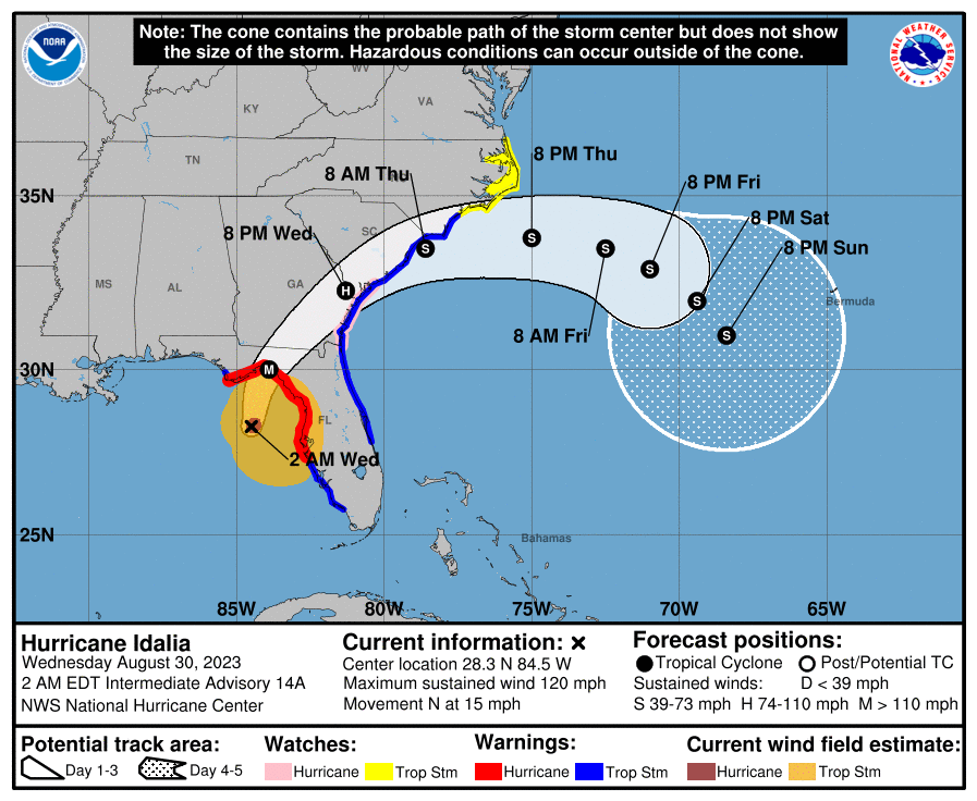
A category 3+ storm can erase structures, buildings and familiar landscape. Idalia is expected to be similar in forward speed to Hurricane Charley which impacted the SW coast of Florida in 2004, but the storm itself will be bigger, wider and carry a larger eyewall.   Some moderate coastal topography will likely change in the 60-mile-wide area of immediate impact/landfall.

Some infrastructure failure should be anticipated, and it will take weeks for restoration. The coastal communities are the most vulnerable; however, the inland impact of this specific storm will be much more significant as the large storm continues unimpeded until the entire eye-wall crosses onto land.

That means communities inland all the way to Georgia and South Carolina could feel hurricane force winds, possibly for several hours. That scale of sustained wind energy will snap power poles and reinforced concrete.

As the backside of the storm then reverses the energy direction, any already compromised structures may not withstand the additional pressure. In many cases the backside of the storm is worse than the front.  If you are inland, prepare yourself for a long duration of extensive wind damage followed by an extended power outage.

For those who are in the path of the storm, there comes a time when all options are removed, and you enter the “Hunkering Down” phase.  You’re just about there now.

(more…)

Fast Moving Hurricane Idalia is Building Quickly – Window for Evacuation Decision Closes Next 12 Hours

First things first, for those writing and texting, I’m fine. I forget that new people don’t know the CERT work we do on the side. I’ve been cleaning, organizing and reloading toolbox containers. You don’t know how much stuff you use, lose and wear out in a year of recovery operations until you need to check inventory. Jumpin ju-ju bones we suck. My tribe is a hot mess, a scruffy mess; and I must have swept 5lbs of sawdust out of the toolbox lol. ~SD

Hurricane Idalia is already being felt on the Southwest coast. Idalia is sucking in energy from a long way, which tells me she’s going to be big, fast. Fortunately, the fast part is good, less time making life miserable. Unfortunately, the fast part is bad, the window for the evacuation decision closes tonight.

ALL PREPARATIONS should be rushed to completion. Overnight tonight we enter hunker down mode (more on that shortly). Get everything done by nightfall tonight.

[Personal non-scientific note. Every time these forecasts have a cone turn to the right; the variance of the forecast accuracy is directly proportional to the eyes distance from the Florida coast when the storm is traveling north. The closer to the coast, the less accurate the prediction… EVERY FRIGGIN TIME (including Charley and Ian).]

[National Hurricane Center] – At 1100 AM EDT (1500 UTC), the center of Hurricane Idalia was located near latitude 24.5 North, longitude 84.8 West. Idalia is moving toward the north near 14 mph (22 km/h). A faster motion toward the north and north-northeast is expected through early Wednesday while Idalia approaches the Gulf coast of Florida. A turn toward the northeast and east-northeast is forecast late Wednesday and Thursday, bringing the center of Idalia near or along the coasts of Georgia and the Carolinas.

Maximum sustained winds have increased to near 85 mph (140 km/h) with higher gusts. Rapid intensification is expected before landfall, and Idalia is forecast to be a major hurricane when it reaches the Gulf coast of Florida Wednesday morning. (read more)

Remember, you are in control right now, not Idalia. She takes control tomorrow.  There is no need for panic or dark imaginings. Calm, prudent preparations should be taken if you are in the zone of uncertainty. A lot of change in impact zone can happen quickly with these northerly moving storms. Storm surge is expected to be significant.

(more…)

Idalia Now Forecast to Become Major Intensity Hurricane Approaching Florida West Coast Wednesday

Forecast updates provide a mix of good and bad news. [National Hurricane Center] On the good side, Idalia looks like she will be fast in forward movement as she arrives in Florida.  On the bad side of the updates Idalia will be bigger, stronger, and the faster forward movement means the hurricane will be felt further inland potentially into southern Georgia.  All advance preparations should be moved to completion within the next 48 hours.

Remember, you are in control.  There is no need for panic or dark imaginings. Calm, prudent preparations should be taken if you are in the zone of uncertainty.  Specific interests in the Tampa/St Pete region should be playing close attention.  A a lot of change in impact zone can happen quickly with these northerly moving storms. Storm surge is expected to be significant.

[National Hurricane Center] – ..”At 700 AM CDT (1200 UTC), the center of Tropical Storm Idalia was located near latitude 20.6 North, longitude 85.2 West. Idalia is moving toward the north near 8 mph (13 km/h). A northward motion is expected through tonight, followed by a faster north-northeast motion on Tuesday and Wednesday. On the forecast track, the center of Idalia is forecast to pass near or over western Cuba tonight, over the extreme southeastern Gulf of Mexico by early Tuesday, and reach the Gulf coast of Florida on Wednesday.

Maximum sustained winds are near 65 mph (100 km/h) with higher gusts. Idalia is forecast to become a hurricane later today and a dangerous major hurricane in the Gulf of Mexico by early Wednesday.”.. (more)

Idalia will come fast, now predicted to make landfall as a category 3+ hurricane.  Those in the cone of uncertainty should pay attention, and people in the Tampa and St Pete region who have really lucked out in the past 30 years, should pay very close attention.

I hope you will understand why my proactive tips, advice and planning have modified since our experience with the September 2022 Hurricane, Ian. {Go Deep} Thankfully Idalia is not expected to be anything similar to slow moving Ian.   Prior preparation advice remains solid and follows below.

(more…)

Tropical Storm Idalia Likely to Become Hurricane Headed to Florida West Coast

Information from the National Hurricane Center [DATA HERE] indicates currently slow-moving Tropical Storm Idalia will likely speed up quickly tomorrow and form a Hurricane in the Gulf of Mexico on Tuesday.  The current cone of uncertainty puts the Northern and Western portion of Florida at greatest risk.

At 100 PM CDT (1800 UTC), the center of Tropical Storm Idalia was located near latitude 20.0 North, longitude 85.8 West. Idalia is moving toward the north near 2 mph (4 km/h), and it is likely to meander near the Yucatan Channel through tonight. A faster motion toward the north is expected on Monday, bringing the system over the eastern Gulf of Mexico.

Maximum sustained winds remain near 40 mph (65 km/h) with higher gusts. Strengthening is forecast, and Idalia is expected to become a hurricane by Tuesday.

Idalia will come fast, most likely making landfall at a category 2 hurricane.  Those in the cone of uncertainty should pay attention, and people in the Tampa and St Pete region who have really lucked out in the past 30 years, should pay very close attention.

I hope you will understand why my proactive tips, advice and planning have modified since our experience with the September 2022 Hurricane, Ian. {Go Deep} Thankfully Idalia is not expected to be anything similar to Ian.  However, for those in the Tampa/St Pete area, do not be complacent.   This is a large metropolitan area with a similar demographic to the impact zone of Ian.

(more…)