The time for preparations and/or evacuation decisions is past. This is pure hunker down time right now. Those in the immediate impact zone of Hurricane Idalia will see rapidly deteriorating weather conditions over the next few hours. Landfall expected at sunrise Wednesday.
Idalia will remain at hurricane strength throughout Georgia and likely into South Carolina. There will be a large swath of area impacted. There will be power outages and severe disruptions in all three states throughout the day today.
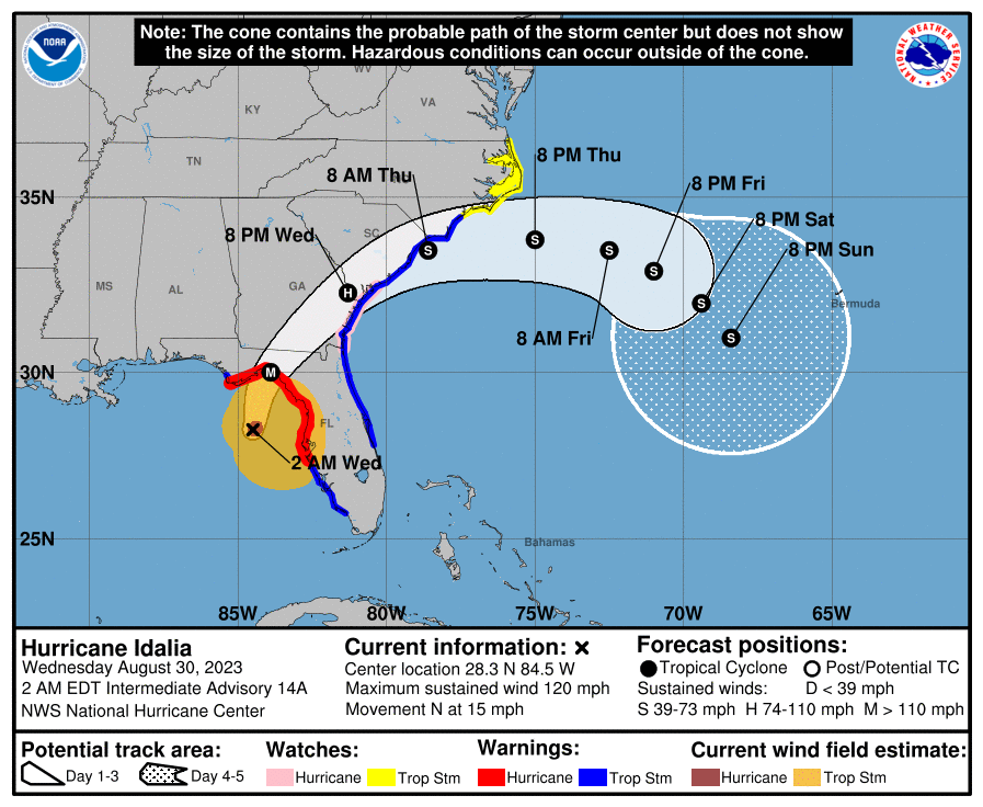
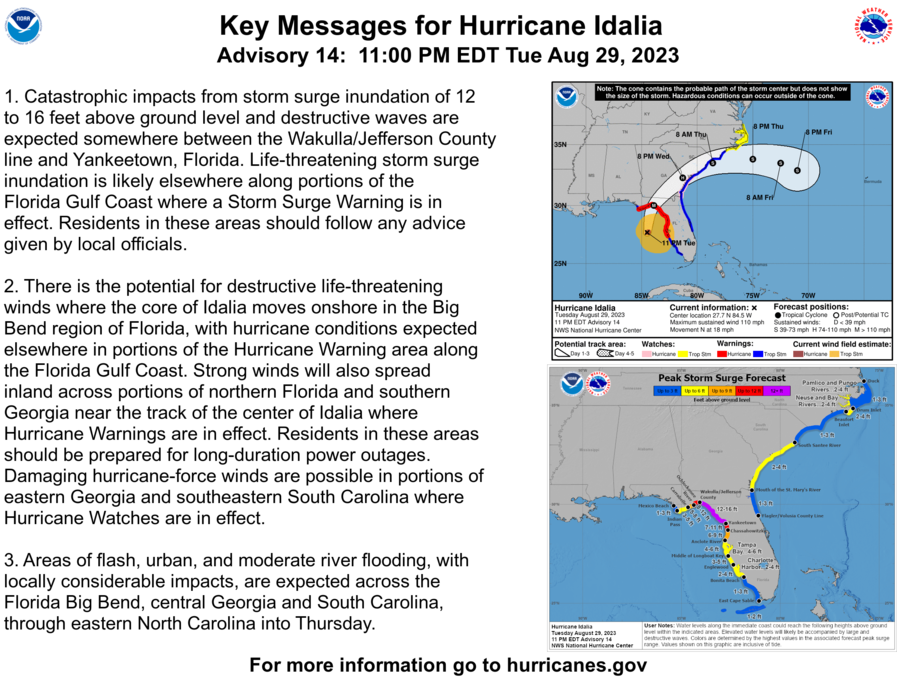
At 200 AM EDT (0600 UTC), the center of Hurricane Idalia was located near latitude 28.3 North, longitude 84.5 West. Idalia is moving toward the north near 15 mph (24 km/h). A northward to north-northeastward motion is expected through morning, with Idalia’s center forecast to reach the Big Bend coast of Florida this morning. After landfall, Idalia is forecast to turn toward the northeast and east-northeast, moving near or along the coasts of Georgia, South Carolina, and North Carolina late today and Thursday.
Hurricane Hunter aircraft data indicate that maximum sustained winds have increased to near 120 mph (195 km/h) with higher gusts. Idalia is a category 3 hurricane on the Saffir-Simpson Hurricane Scale. Additional strengthening is forecast, and Idalia is forecast to become a category 4 hurricane before it reaches the Big Bend coast of Florida this morning. Idalia is likely to still be a hurricane while moving across southern Georgia, and possibly when it reaches the coast of Georgia or southern South Carolina late today. (more)
What follows is the #1 requested information by those who nervously anticipate the arrival of their first Hurricane experience.
As many long-time readers will know, we do have a little bit more than average experience dealing with the aftermath of hurricanes. I ain’t no expert in the before part; you need to heed the local, very local, professionals who will guide you through any preparation, and neighborhood specific guidelines, for your immediate area.
But when it comes to the ‘after part’, well, as a long-time CERT recovery member perhaps I can guide you through the expectation and you might find some value. Consider this little word salad a buffet, absorb what might be of value pass over anything else.
A category 3+ storm can erase structures, buildings and familiar landscape. Idalia is expected to be similar in forward speed to Hurricane Charley which impacted the SW coast of Florida in 2004, but the storm itself will be bigger, wider and carry a larger eyewall. Some moderate coastal topography will likely change in the 60-mile-wide area of immediate impact/landfall.
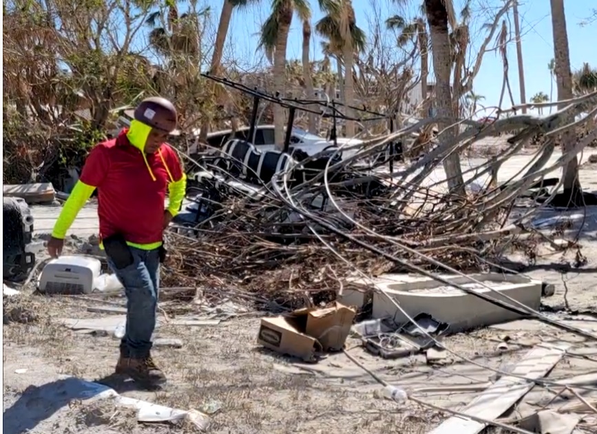
Some infrastructure failure should be anticipated, and it will take weeks for restoration. The coastal communities are the most vulnerable; however, the inland impact of this specific storm will be much more significant as the large storm continues unimpeded until the entire eye-wall crosses onto land.
That means communities inland all the way to Georgia and South Carolina could feel hurricane force winds, possibly for several hours. That scale of sustained wind energy will snap power poles and reinforced concrete.
As the backside of the storm then reverses the energy direction, any already compromised structures may not withstand the additional pressure. In many cases the backside of the storm is worse than the front. If you are inland, prepare yourself for a long duration of extensive wind damage followed by an extended power outage.
For those who are in the path of the storm, there comes a time when all options are removed, and you enter the “Hunkering Down” phase. You’re there now.
 Fortunately, just like Charley, this particular hurricane will move fast and that might mitigate some of the coastal storm surge (only one part of one tidal cycle). However, in totality from impact through recovery this is going to be a long-duration event.
When the sustained winds reach around 45mph most emergency services stop. This makes things a heck of a lot safer in the aftermath; and much easier and safer during the rebuild.
♦ Hurricanes can be frightening; downright scary. There’s nothing quite like going through a few to reset your outlook on just how Mother Nature can deliver a cleansing cycle to an entire geographic region.
The sounds are scary. Try to stay calm despite the nervousness. Telephone and power poles, yes, even the concrete ones, can, and likely will, snap like toothpicks. Trees will bend and break. When the roof shingles are peeling off, it sounds like horses running across your roof. The sounds are dramatic.
There’s a specific sound when you are inside a hurricane that you can never forget. It ain’t a howl, it’s a roar. It is very unique sound in depth and weight. Yes, within a hurricane wind has weight. Stay clear of windows and doors, and within an interior room of the house or apartment if possible. That scary roar sounds like it won’t ever quit…. it will… eventually; but at the time you are hunkering down, it doesn’t seem like it will ever end.
A hurricane wind is a constant and pure rage of wind that doesn’t ebb and flow like normal wind and storms. Hurricane wind is heavy, it starts, builds and stays; sometimes for hours. Relentless, it just won’t let up. The constant rage is fueled by simultaneous surges inside it. Just like the water that fuels her, Idalia will deliver a rage of wind energy that has surges within the relentless force.
And then, suddenly, depending on Idalia’s irrelevant opinion toward your insignificant presence, it will stop. Judging by the forward speed the hurricane force wind will likely last around 2 to 3 hours before it stops.
Then silence. No birds. No frogs. No crickets. No sound.
Nature goes mute. It’s weird.
We have no idea how much ambient noise is around us, until it stops.
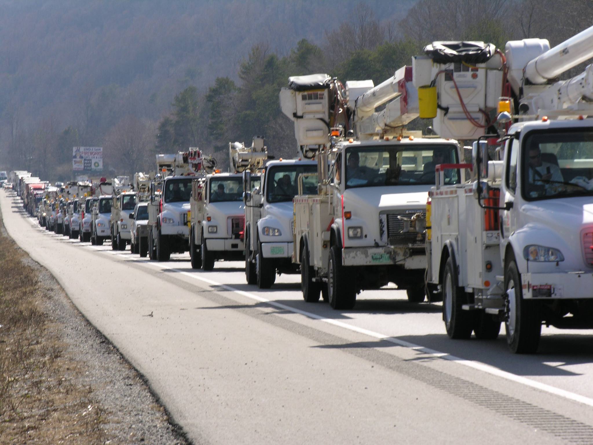 Due to the speed of the storm, there will be convoys coming to construct a pre-planned electricity grid recovery process even before nightfall tomorrow.
Convoys from every city, town and state from the east-coast to the mid-west. A glorious melding of dirty fingernails all arriving for the meet-up.
Depending on your proximity to the bigger picture objectives at hand, you will cherish their arrival.
But first, there will be an assessment.
The convoys will stage at pre-determined locations using radios for communication. Most cell phone services will likely be knocked out. Recovery teams will begin a street-by-street review; everything needs to be evaluated prior to thinking about beginning to rebuild a grid. Your patience within this process is needed; heck, it ain’t like you’ve got a choice in the matter…. so just stay positive.
Meanwhile, you might walk outside and find yourself a stranger in your neighborhood.
It will all be cattywampus.
Trees gone, signs gone, crap everywhere, if you don’t need to travel, DON’T.
I mean CRAP e.v.e.r.y.w.h.e.r.e.
Stay away from power-lines.
Try to stay within your immediate neighborhood for the first 36-48 hours. Keep the roadways and main arteries clear for recovery workers, power companies and fuel trucks.

Be entirely prepared to be lost in your own neighborhood and town for days, weeks, and even months. Unknown to you – your subconscious mind is like a human GPS mapping system. When that raging Idalia takes away the subconscious landmarks I guarantee you – you are gonna get lost, make wrong turns, miss the exit etc.
It’s kinda funny and weird at the same time.
Your brain is wired to turn left at the big oak next to the Church, and the road to your house is likely two streets past the 7-11 or Circle-k. You don’t even notice that’s how you travel around town; that’s just your brain working – it is what it is.
Well, now the big oak is gone; so too is the Circle-K and 7-11 signs. Like I said, everything is cattywampus. Your brain-memory will need to reboot and rewire. In the interim, you’re gonna get lost… don’t get frustrated.
No street signs. Likely no stop signs. No traffic lights.
Remember, when it is safe to drive, every single intersection must be treated like a four-way stop…. and YOU ARE GOING TO HAVE TO PAY ATTENTION. Even the major intersections.
You’ll need to override your brain tendency to use memory in transit. You’ll need to pay close attention and watch for those who ain’t paying close attention. Travel sparingly, it’s just safer.
Check on your-self first, then your neighbors. It don’t matter if you’ve never said a word to the guy in the blue house before. It ain’t normalville now.
Break out of your box and check on the blue house down the street too. In the aftermath, there’s no class structure. Without power, the big fancy house on the corner with a pool is just a bigger mess. Everyone is equally a mess.
The first responders in your neighborhood are YOU.
You, the wife, your family, Mrs. Wilson next door; Joe down the street; Bob’s twin boys and the gal with the red car are all in this together. If you don’t ordinarily cotton to toxic masculinity, you will worship it in the aftermath of a hurricane. Git-r-done lives there.
Don’t stand around griping with a 40′ tree blocking the main road to your neighborhood. Figure out who’s got chainsaws, who knows how to correctly use them, and set about safely clearing the road. If every neighborhood starts clearing their own roadways, the recovery crews can then move in for the details.
Stage one focuses on major arteries… then secondary… then neighborhood etc. It’s a process. Oh, and don’t get mad if your fancy mailbox is ploughed-over by a focused front end loader who is on a priority mission to clear a path. Just deal with it. Those same front-end loaders will also be removing feet of sand from coastal roads. Don’t go sightseeing… stay in your neighborhood.
For the first 36-48 hours, please try to stay close to home, in your neighborhood. Another reason to stay close to home is the sketchy people who can sometimes surface, looters etc. Staying close to home and having contact with your neighbors is just reasonable and safer.
Phase-1 recovery is necessarily, well, scruffy…. we’re just moving and managing the mess; not trying to clean it up yet. It’ll be ok. There are going to be roofing nails everywhere, and you will likely get multiple flat tires in the weeks after the hurricane.
After this storm half of the people living near the impact zone are going to fit into two categories, two types of people: (1) those with a new roof; or (2) those with a blue roof (tarp).
Keep a joyous heart filled with thankfulness; and if you can’t muster it, then just pretend. Don’t be a jerk. You will be surrounded by jerks…. elevate yourself. If you need to do a few minutes of cussing, take a walk. Keep your wits about you and stay calm.
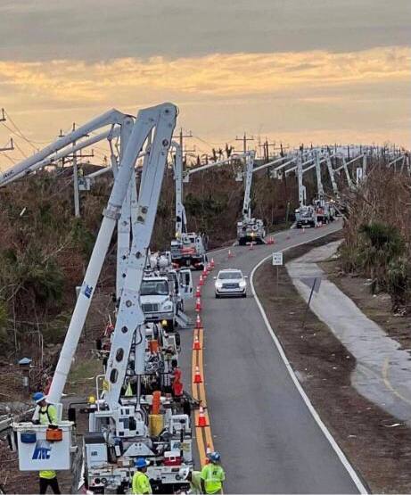 Now, when the recovery teams arrive…. If you are on the road and there’s a convoy of utility trucks on the road, pull over. Treat power trucks and tanker trucks like ambulances and emergency vehicles. Pull over, give them a clear road and let them pass.
When everyone gets to work, if you see a lineman, pole-digger or crew say thanks. Just simple “thanks”. Wave at them and give them a thumbs-up. No need to get unnecessarily familiar, a simple: “thank you for your help” will suffice. You know, ordinary people skills. The stuff that was common before the internet.
Many of these smaller crews will be sleeping in cots, or in their trucks while they are working never-ending shifts. Some will be staging at evacuation shelters, likely schools and such. The need to shelter people and recovery crews might also delay the re-opening of schools.
Once you eventually start getting power back, if you see a crew in a restaurant, same thing applies… “thanks guys”. If you can pay their tab, do it. If you can pay their tab without them knowing, even better.
Same goes for the tanker truckers. The convenience stores with gas pumps are part of the priority network. Those will get power before other locales without power. Fuel outlets are a priority. Fuel is the lifeblood of recovery. Hospitals, first responders, emergency facilities, fuel outlets, then comes commercial and residential.
Remember, this is important – YOU are the first responder for your neighborhood. Don’t quit. Recovery is a process. Depending on the scale of the impact zone, the process can take days, weeks and even months.
Take care of your family first; then friends and neighborhood, and generally make a conscious decision to be a part of any needed solution.
Pray together and be strong together. It might sound goofy to some, but don’t be bashful about being openly thankful in prayer.
It will be ok.
It might be a massive pain in the a**, but in the end, it’ll be ok.
√Andrew
√Jeanne
√Frances
√Ivan
√Charley
√Irma
√Michael
√Ian
Keep a good thought. Who knows, we might even end up shaking hands.
It’ll be OK. I Promise.
Love to all,
Sundance
[¹Support CTH Here]

¹Footnote – If you know any good deals on window A/C units in Florida, drop me an email (or comment). I gave away all that we had during Ian, and I would like to purchase some new ones for people who will need.
Florida Gas Stations Receive Contaminated Fuel Right Before Hurricane Idalia Makes Landfall
The Department of Agriculture and Consumer Services (FDACS) has reported fuel contamination could impact residents who are evacuating from Florida’s coast.
FDACS reported fuel contamination has occurred at dozens of gas stations that were serviced by the Port of Tampa.
In a press release, FDACS revealed, “Any fuel purchased after 10 a.m. on Saturday, August 26, at stations supplied by Citgo from the Port of Tampa has a strong likelihood of being contaminated with diesel fuel.”
there is a LOT of misinformation out there about how to “drain diesel” out of gasoline. Diesel and gasoline are totally MISCABLE…they mix…and DO NOT SEPARATE. The ONLY way to prevent serious problems in a gasoline engine that has diesel in the tank is to STOP ENGINE. Have a shop remove all fuel from the tank AND remove all fuel from the injectors and fuel lines and rails. change the plugs and perform a cat clean and o2 sensor clean and of course change the oil and oil filter.
Had a friend a few years back…long story. He drained all the fuel from the tank. But did not remove it from fuel lines and rails and injectors. He ended up with quite a bit of damage…new injectors…new plugs…new cats…and new o2 sensors.
if you suspect you have filled your gasoline engine with diesel…get a professional shop to tow it and get it all removed and flush it completely.
I would also keep a receipt and have a witness with a selfie showing the time and date that you filled the tank at these cross contaminated fuel stations. there are going to be lots of lawsuits I would imagine.
It is much more complicated then most think.
If anyone knows how sensitive some diesel systems are and how contaminated fuel getting past can cause expensive havoc on the complete fuel system. A gas engine is a bit less sensitive but still can cause major issues.
Is Citgo or the port where the “Human error BS” gonna pay for all the destruction and repairs?
Has meatball or anyone in the chain of Florida government gonna hold those responsible accountable ?
Prayers for all in the storm’s path, as well as for those who have relocated to be out of it.
Hear our prayers, O Lord.
Pressure dropped to 944mb, clear signal of increasing strength, moving quickly however is a good sign high altitude, may be less destructive…
A cat four with a fast ground track. Destruction spread over a larger area. Shallow waters where she’s gonna strike.
Watching with prayers….
Amazon had 5000 BTU window units for $117 (I think)…possibly $157
Maybe this baby will rock Sea Island.
Looks like landfall near Keaton Beach and Perry right behind it.
Saint Teresa on the West side is 7mph to 14 gusts.
East side
11-12 mph at Keaton Beach now.
30-44 at Cedar Key
Eye wall still not that large compared to some other blows.
Horseshoe Beach getting pounded and multiple tornado warnings already
https://theconservativetreehouse.com/blog/2023/07/06/prayer-requests-20/
I am at a rest stop on I-10 just to the nw of the center – big wind sheeting rain got good radar coverage online mobile here. Wondering about storm surge, looks like it came in directly across Keaton Beach.. 12V Florida Man Mobile here!
I am about to have another sourdough English muffin as the first one left me a might peckish. I am beyond amazed we never lost power. Keep On Truckin’, bro.
So very thankful to hear y’all are okay.
Glad you’re okay. Stay safe!
Bye Bye Idalia! Welcome to Georgia!.
All parts still attached, time for a hot breakfast! God bless us, everyone!
Man! I love this guy. I think after Donald Trump, Sundance is my next favorite human being on this planet!
Thank you for all you do. And I’m in MO, not even affected directly by the hurricane! But your knowledge, kindness, steadfastness and courage are an inspiration!
Jordan Peterson is next on the list. He had his slightly leftist worldview shattered into reality. He still does not understand VSGPDJT!
Crossing my sore fingers! My garage and shed are full of all our outdoor stuff.
Hopefully, my coastal Georgia county’s hurricane deflection shields are going to hold once again. 125 years without a direct hit. We may get some high winds, but most of the rain is west of the center of rotation. Sadly, we’ll lose power, which is normal for bad thunderstorms.
The Altamaha River estuary is going to be high with all the rain upriver and the coming king tide.
Lol! My garage also looks like an episode of “Hoarders” packed with trash cans, kayaks, a john boat, rockin chairs, you-name-it!
Your Georgia county might have hurricane deflection shields but apparently Tampa-St.Pete has a cloaking device?
I find the shift of the storm track so far North kind of interesting given the High Pressure Dome impacting the Southwest has not changed and the prevailing track of Jet Stream still remains primarily North to South.
Call me skeptical and cynical but combine the “Reporting” of the Storm Track with now emerging story of CITCO gas delivery SNAFU’s … I just have a bad itch in the middle of my back.
The US Government and Democrat Run areas have no shame at this point when it comes to causing damage and human misery.
It will be interesting to hear what Dane Wiginton observed at geoengineering.org
Gauge at Steinhatchee reports 8′ inundation. It hasn’t updated in over an hour though, maybe it’s gone or underwater.
https://water.weather.gov/ahps2/hydrograph.php?wfo=tae&gage=stif1
Lots of Storm Chasers Live Views in different locations included:
‘LIVE – Major Hurricane Idalia Coverage With Storm Chasers In The Eye – Live Weather Channel…’
Anybody else see that projected path as a possible double hit across FL?
Not according to Windy dot com.
There is another low departing Africa pretty much right now which will be west and north of the islands in 10 days…it appears to want to turn north and pass north of Puerto Rico and east of the Bahamas….watching it closely and will have a firmer track in 2-3 days.
Source: Windy dot com
Correction: Departing Africa Friday and north and west of PR in eight days
So far I have seen news reports of only two fatalities (I hate to say “only” about fatalities) which would be a pretty good outcome…
If we read about the same fatalities, both cases appear to occur operating a vehicle.
resourceful lads
When it hit:
And, there is this:
https://www.fox13news.com/news/tree-falls-on-governor-ron-desantis-mansion-hurricane-idalia
It’s heartbreaking when such magnificent trees are destroyed. For 100 years, it has been growing. A tree to be honored.
That it fell on his house, well, that’s another story.
“IDALIA MEGA STORM SURGE WITH HURRICANE HAMMERING CEDAR KEY, FLORIDA”
(Good early footage… but also an example of things you should never do during a hurricane!)
https://www.bitchute.com/video/tLkjMA2dcGe8/
Family in Florida came through another one. Tampians didn’t even lose power. Wacissa has loads of tree damage and no power, but nothing hit their homes. Last text from Madison said weather was bad but they were holding on; haven’t heard anything since this morning. Gainesville okay, Dunnellon safe, lots of water in Crystal River and Homosassa but they’ll get through it.
General consensus was they were expecting worse and thank God for what they got.
Hey Sundance, I just saw this on the WINK news website in case you were not aware of this resource center being set up,
Multi-Agency Resource Center in Pine Island after Hurricane Idalia (winknews.com)