According to most forecasters and the National Weather Service, a significant weather event begins tonight and will likely bring extreme snow and ice to much of the U.S. mainland.
NATIONAL WEATHER SERVICE -…Major winter storm to begin impacting the Central and Southern Plains today, before moving into the Mid-South, Mid-Atlantic, and Northeast this weekend… ♦Catastrophic ice accumulations are expected from the Southern Plains to the Southeast/Mid-Atlantic… ♦Dangerously cold temperatures set to expand across much of the eastern two-thirds of the U.S. through early next week.
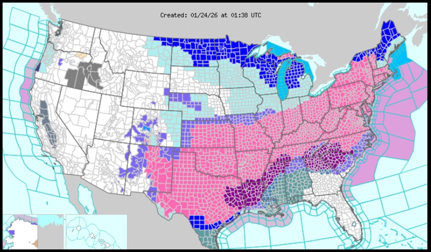
A significant winter storm is forecast to begin in the Southern Rockies and Central/Southern Plains today, progressing eastward through the Mid-South and into the Mid-Atlantic and the Northeast through Monday. This is expected to produce large swaths of heavy snow, sleet, and freezing rain, bringing hazardous driving conditions, power outages, and tree damage. The heaviest snowfall is expected across a large area, including parts of the Southern Rockies, Plains, and through the Mid-Atlantic and Northeast. Snowfall totals are expected to exceed one foot in parts of these areas, and widespread travel disruptions are likely.
South of the snow axis, widespread freezing rain and sleet are expected, affecting the Southern Plains, Lower Mississippi Valley, Tennessee Valley, and much of the Mid-Atlantic. Catastrophic impacts are expected where freezing rain totals exceed half an inch, with over an inch expected in parts of Louisiana, Arkansas, Mississippi, and the Southern Appalachians.

