Forecast updates provide a mix of good and bad news. [National Hurricane Center] On the good side, Idalia looks like she will be fast in forward movement as she arrives in Florida. On the bad side of the updates Idalia will be bigger, stronger, and the faster forward movement means the hurricane will be felt further inland potentially into southern Georgia. All advance preparations should be moved to completion within the next 48 hours.
Remember, you are in control. There is no need for panic or dark imaginings. Calm, prudent preparations should be taken if you are in the zone of uncertainty. Specific interests in the Tampa/St Pete region should be playing close attention. A a lot of change in impact zone can happen quickly with these northerly moving storms. Storm surge is expected to be significant.

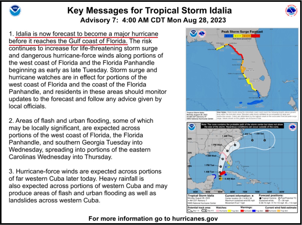
[National Hurricane Center] – ..”At 700 AM CDT (1200 UTC), the center of Tropical Storm Idalia was located near latitude 20.6 North, longitude 85.2 West. Idalia is moving toward the north near 8 mph (13 km/h). A northward motion is expected through tonight, followed by a faster north-northeast motion on Tuesday and Wednesday. On the forecast track, the center of Idalia is forecast to pass near or over western Cuba tonight, over the extreme southeastern Gulf of Mexico by early Tuesday, and reach the Gulf coast of Florida on Wednesday.
Maximum sustained winds are near 65 mph (100 km/h) with higher gusts. Idalia is forecast to become a hurricane later today and a dangerous major hurricane in the Gulf of Mexico by early Wednesday.”.. (more)
Idalia will come fast, now predicted to make landfall as a category 3+ hurricane. Those in the cone of uncertainty should pay attention, and people in the Tampa and St Pete region who have really lucked out in the past 30 years, should pay very close attention.
I hope you will understand why my proactive tips, advice and planning have modified since our experience with the September 2022 Hurricane, Ian. {Go Deep} Thankfully Idalia is not expected to be anything similar to slow moving Ian. Prior preparation advice remains solid and follows below.
In my last set of proactive suggestions, {GO DEEP HERE} I focused first and foremost on something few discuss, mental capability. Due to what I witnessed in Hurricane Ian with the people of the area, I am always going to put this into the analysis now to provide consideration that few understand. I saw Ian break strong people down and create a PTSD demographic I have never experienced before.
What follows below are things to consider if you are prepping for a hurricane impact and/or deciding whether to stay in your home or evacuate. Standard hurricane preparations should always be followed. Protect your family, secure your property and belongings, and prepare for the aftermath.
This is not a message of alarm. This is a message of prudent action that can assist your consideration, as each person evaluates their situation. What you do before the hurricane hits is going to determine where you are in the recovery phase.
Additionally, and this should be emphasized and discussed within your family, if you cannot be self-sufficient in the aftermath – for any reason, then you should evacuate. Self-sufficiency in this context requires being able to cope for up to several weeks:
(1) potentially without power; (2) potentially without potable running water (3) potentially without internet service; (4) potentially without communication outside the region; and (5) with limited municipal and private sector assistance. If you decide you cannot deal with these outcomes, you should evacuate.
Additionally, as a family or individual, you should also honestly evaluate:
(1) your physical abilities; (2) your emotional and psychological ability to withstand extreme pressures; and (3) your comfort in losing daily routines, familiar schedules and often overlooked things you might take for granted.
Post hurricane recovery is fraught with stress, frustration and unforeseeable challenges. {GO DEEP}
For those in the cone of uncertainty, remember, planning and proactive measures taken now can significantly reduce stress in the days ahead. Plan when to make the best decision on any evacuation (if needed). For now, consider Tuesday night the decision timeframe. As a general rule: take cover from wind – but evacuate away from water.
DAY ONE (Sunday)
- Determine Your Risk
- Make a Written Plan
- Develop and Evacuation Plan
- Inventory hurricane/storm supplies.
DAY TWO (Monday)
- Get Storm Update
- Assemble and Purchase Hurricane Supplies
- Contact Insurance Company – Updates
- Secure Important Papers.
- Strengthen and Secure Your Home √
- Make Evacuation plan for your Family.
DAY THREE (Tuesday)
- Get Storm Update
- Re-Evaluate your Supplies based on storm update.
- Finish last minute preparation.
- Assist Your Neighbors
- If Needed – Tuesday night – Evacuate Your Family
Communication is important. Update your contact list. Stay in touch with family and friends, let them know your plans. Select a single point of contact for communication from you that all others can then contact for updates if needed. Today/tomorrow are good days to organize your important papers, insurance forms, personal papers and place them in one ‘ready-to-go’ location.
Evaluate your personal hurricane and storm supplies; update and replace anything you might have used. Assess, modify and/or update any possible evacuation plans based on your location, and/or any changes to your family status.
Check your shutters and window coverings; test your generator; re-organize and familiarize yourself with all of your supplies and hardware. Check batteries in portable tools; locate tools you might need; walk your property to consider what you may need to do based on the storms path. All decisions are yours. You are in control.
Consider travel plans based on roads and traffic density. Being proactive now helps to keep any future stress level low. You are in control. If you have pets, additional plans may be needed.
One possible proactive measure is to make a list of hotels further inland that you would consider evacuating to. Make that list today and follow updates of the storms’ progress.
Depending on information later today, tomorrow you might call in advance and make a reservation; you can always cancel if not needed. It is better to have a secondary evacuation place established in advance. Being proactive reduces stress. Even if you wait until much later to cancel, it is better to pay a cancellation fee (usually one night charge) than to not have a plan on where to go. Trust me, it’s worth it.
Protect your family. Make the list of possibilities today, make the booking decision in the next 24 hrs.
Look over the National Hurricane Center resources for planning assistance.

If you do not handle stress well, leave.
If you cannot be self-sufficient in the aftermath, leave.
If you choose to stay pay super close attention to the exact path of the storm. A few miles make a massive difference when you are dealing with the possibility of encountering the eyewall of a hurricane.
This is a fury of nature, a battle where the odds are against you, that you may or may not be aware you are contemplating when you are choosing to stay or evacuate. It’s not the hurricane per se’, it’s that much smaller killer buzzsaw – the eyewall- that you are rolling the dice, never to see.
When it comes to the eyewall, the truest measure of the “cone of uncertainty“, the difference between scared out of your mind (victim) and a fight to avoid death (survivor), is literally a matter of a few miles. And there ain’t no changing your mind once it starts.
The worst part of the storm surge will happen immediately to the south of the arriving storm. The onshore winds will push the water. Fortunately, with Idalia, it will likely be only one tidal cycle in duration as the storm is moving quickly.
♦ Hardening your home is a matter of careful thought and physical work. However, every opening into your structure must be protected, leaving yourself with one small exit opportunity just in case. Hopefully you have a bolted door with no glass windows you can use as an emergency exit. If not, select a small window and leave only enough room uncovered for you to get out in case of emergency or structural collapse.
Beyond the ordinary supplies like drinking water, batteries, flashlights, battery or hand-crank radio, generators, gasoline, etc. Evaluate the scale of what you have against the likelihood of weeks without power or water. A few pro tips below:
♦ You can always tell those people who have been through direct hurricane impacts by how they park their cars. If you lose your Florida garage door, you will more than likely lose your roof. [Example Here] That’s just the reality of having a massive opening in your structure to 150 mph winds that will lift the trusses.
If you have two vehicles, put one vehicle inside the garage with the front bumper against the door to help stop the flex (do this carefully). Put the other vehicle outside blocking the garage door facing down the driveway or facing parallel to the garage. The goal is to use the aero dynamics of the car to push the wind away from the door and provide protection.
Purchase a cheap car cover to protect the outside vehicle and/or use old blankets (cable ties, bungee cords) to stop the outside vehicle from getting sandblasted and destroyed. Place double folded corrugated cardboard in front of the radiator to protect it from storm debris. [Example: A five-inch piece of asphalt roof shingle sliced through the grill of my truck during Ian and embedded in the radiator like a razor blade. I found it when the truck overheated.]
Additionally, if you live in a flood zone, or if you are concerned about storm surge, the day before impact take your #1 car to the nearest airport or hotel with a parking garage and park in the upper levels. Take an uber back home if you don’t have a friend or partner to help you. This way you know you will have one workable vehicle, just in case.
♦ Throw all of your patio furniture in the swimming pool if you cannot bring it inside. You can also use your pool water and a bucket to manually flush the toilets after the storm. Also dump extra chlorine into the pool because if your power goes out your pump will not run. The pool will turn into an algae filled mess quickly.
♦ Put three clean and sanitized 30-gallon trash cans in the shower and fill them with water before the storm. This will give you 90 gallons of water for cooking and personal hygiene. You will also need water to manually flush your toilets (if you have a swimming pool, use that water). Bottled water is great for drinking, hydrating and toothbrushing, but you will need much more potable water if the municipal supply is compromised or broken.
♦ A standard 6,500-to-8,500-watt generator will run for approximately 8 hours on five gallons of gasoline. Do not run it all the time. Turn it on, chill the fridge, make coffee, use the microwave or charge stuff, then turn it off. Do this in 4-hour shifts and the fridge will be ok and your gasoline will last longer. Gasoline is a scarce and rare commodity in the aftermath of a hurricane. Gas stations don’t work without power. Check the oil in the generator every few days. Also, have a can of quick start or butane available in case the generator starts acting up.
♦ Extension cords. If you are purchasing them buy at least one 50 to 100′ extension cord with a triple ponytail. This way you can use one cord into a central location to charge up your electronic devices. Establish a central recharging station for phones, pads, laptops, and rechargeable stuff.
♦ Purchase a box of “contractor garbage bags” and just keep them in the garage. These are large, thick, industrial trash bags that fit 40-gallon drums (Home Depot or Lowes). They can be used for trash, or even cut open for tarps in the aftermath of a storm. These thick mil contractor bags have multiple uses following a hurricane.
♦ Do all of your laundry before the hurricane hits. You will likely not have the ability again for a few weeks.
♦ Fill any empty freezer space with bottled water, remove some water to allow for expansion beforehand. You can move those frozen jugs of water into the fridge to help keep temp down after storm, if no power.
♦ Cook a week’s worth of meals in advance of the hurricane. Store in fridge so you can microwave for a meal. Eating a constant diet of sandwiches gets old after the first week. Dinty Moore canned beef stew and or Chef-boy-ardee raviolis can make a nice break…. anything, except another sandwich.
♦ Have bleach for use in disinfecting stuff before and after a hurricane. Also have antibiotics and antiseptics for use. Hygiene and not getting simple infections after a hurricane is critical and often forgotten. Again, this is where the extra potable water becomes important. Simple cuts and scrapes become big deals when clean potable water is not regularly available. Keep your scrapes and abrasions clean and use antiseptic creams immediately.
♦ Do not forget sunscreen and things to relieve muscle aches and pains. Hurricane recovery involves physical effort. You will be sore and/or exposed to the elements. Remember, it’s all about self-sufficiency because the normal services are not available. A well-equipped first aid kit is a must have.
♦ Buy a small camping stove. Nothing big or expensive, just something you can cook on outside in case of emergency. It will be a luxury when you are 2+ weeks without power and all the stores and restaurants are closed for miles.
♦ Those small flashlights that you can strap around your head that take a few AAA batteries? Yup, GOLD. Those types of handsfree flashlights are lifesavers inside and outside when you need to see your way around. Nighttime is especially dark without electricity in the entire town. Doing stuff like filling a generator with gasoline in the middle of the night is much easier with one of those head strap flashlights. Strongly advise getting a few, they’re inexpensive too.
♦ Cash. You will need it. Without power anything you may need to purchase will require cash, especially gasoline. Additionally, anyone you hire to help or support your immediate efforts will need to be paid. Cash is critical. How much, depends on your individual situation, but your cash burn rate will likely go into the thousands in the first few days. Also keep in mind, you may or may not be able to work and without internet access even getting funds into place could be challenging.
♦ Hardware. A box of self-tapping sheet metal screws (short and long) is important, along with a box or two of various wood screws or Tyvex screws. A battery drill or screw gun is another necessity. These are for use in securing stuff now, and in temporary repairs after the damage of the storm has subsided. Check all of this stuff during hurricane prep.
Latest NHC advisory has it still as a Tropical Storm. It has been trying to intensify significantly today a couple times and even briefly tried to build an eyewall. However some decent NW wind shear aloft kept inhibiting this.
Unfortunately that wind shear is about to depart as Idalia moves north of it’s main influence. People need to take this seriously but it could easily rapidly intensify over a 24 hour period before landfall. (perhaps even beyond Cat 3)
Just look how quickly Franklin intensified in Atlantic today in just 6-10 hour span.
The problem is the water temperature in the gulf. Today the water temperature in some parts today was a staggering 88F. This will feed the storm and provide it with a massive power. We could be in for a very nasty time here in Florida.
It’s early but speed right now is 8 mph. At that rate the hurricane will be picking up a lot of energy. Extrapolating from general hurricane experience from 30 years in Florida, I wouldn’t be surprised to see a bump up from 3 to 4 tomorrow.
….just before it makes landfall
…Humberto 2007 is also a worthy study of rapid intensifucation…and unanticipated path change…
It caught me by surprise….
We’re on the Delmarva peninsula should be OK
I have always read Sundance’s hurricane tips from Canada with a degree of curiosity.
We flew into Tampa last week. This afternoon our flights out of Tampa were canceled and we are now here east of Tampa applying these tips.
We stopped for extra water and food supplies. I encouraged my hosts to be prudent.
Thanks Sundance.
DD
When were you supposed to fly out? I hope not today!
Yeah, that’s what I want to know, too.
Nancy. Our flight was scheduled for Tuesday morning. We received notice this afternoon that it has been canceled.
I believe they may be looking to get us perhaps to Orlando or elsewhere.
DD
Sounds like you just missed the last flight out.
Sam thing happened to a sister a couple years back. She was excited to experience her 1st hurricane. (I know, I know, kinda nuts)
Anyway, she came thru it just fine. And now she’s checked that off her “To Do” list.
If this is your 1st, hope you have the same kind of experience she did. Should be good to be with friends.
How is the humidity treating you, DD?
The heat and humidity are not something that I am used to.
My wife and I however would still move to Florida if the opportunity ever came. Wonderful place.
DD
Oh goll, DD, what a time (and place) for you to be in the states! Come again soon under better circumstances!
We’d love to have y’all.
We live in Hilliard, Florida a small town north of Jacksonville and just below the Georgia line. If the hurricane stays on its predicted course we will be hit good and hard. As Sundance said, “There is no need for panic or dark imaginings. Calm, prudent preparations should be taken if you are in the zone of uncertainty.” Great words of wisdom, Sundance lives here in Florida and knows EXACTLY what he is talking about.
Taking Sundance’s advice, we calmly drove to Yulee, Florida where we loaded up with camping gas cylinders from Walmart so we can cook on the back porch using our Coleman, Dual Burner Camping Stove (NEVER use one indoors or you will die of carbon monoxide poisoning).
Being in a rural area we have a water well with an electric pump so we also bought several cases of drinking water. The electricity here often goes out during the smallest of rainstorms! Even in good weather the power will go out for a second or two every other day! Forget setting clocks.
Finally we very calmly visited the liquor to load up with the most essential of all survival items. Gin and Tonic’s work wonders in a power cut and if things get really rough there is the ever calming bourbon whiskey to come to the rescue! Wish us luck, the Bat.
Our main worry is the potential for major damage to our house. Hopefully it won’t be too bad as the storm is fast moving.
Prayer from WV.
more prayers from WV.
Prayers for Florida from Texas! 🙏
Praying in SoCal!
Windy dot com shows landfall 40-50? Miles east of Tallahassee at 28.97 HG…0900 HRS…
it’s strengthening…
Rapid Intensification is a real issue due to water temperatures…if you are even on the edge of predicted storm surge…get out…the shape of the coastline and rapid forward movement of the storm dies not look good…
You DON’T want to risk the storm surge….hide from the wind, run from the water…
I personally know a big ol’ boy…co-worker and friend… who literally shot his way out of his attic with a 12 gauge shotgun due to storm surge…
Bridge City TX….
He’s a big, loud guy but he still goes quiet when hurricane talk comes up…
You can survive the wind…but the storm surge will kill you.
Windy dot com
Humberto 2007….spun up from 45 mph to 90 mph and just as quickly changed direction from due north to 25-45 degrees east of north…snap…just like that.
Rapid Intensification is real…it happens…it has happened in Florida…
Hide from the wind, run from the water.
that is a great website. I’ve been aware of it and using it for years here on the NC coast. Best wishes and be safe to all those in Florida.
I checked it out earlier, super graphics! Thanks for info.
Here in Melbourne, Fl we should be spared this. But my kids are in Orlando and it could get ugly there.
We lived in Melbourne when David went right over us in 1979. Fortunately it was only Cat 1 at that point. Watching the eye pass was eerie.
The right side of the hurricane is the worst!
Take care of yourself and your family Sundance. I am praying you all stay safe.
I grew up on South Beach ((poor area) in the 50’s through 70’s. We got hit atleast twice a year on a regular basis. Sometimes Biscayne Bay would merge with the Atlantic Ocean. The most dangerous times would be afterwards. Lots of live downed powerlines in 5 foot of standing water.
God bless and keep you and your loved ones , Sandy.
Back when you could still find a parking spot off s. Alton rd.
Have all of you Florida Treepers in my thoughts and prayers. Stay safe Patriots!
This is no joke, Sundance covered what you will require to function, should you hesitate with one or more evacuate, do not hesitate. Your belongings are replaceable, your life or loved ones lives are not, do not take this lightly, do not count on your neighbor, do not count on your municipality, if you are not self sufficient you need to evacuate. Should you feel self sufficient be prepared for the hardest event you will ever endure. It is simple to evacuate and return when safe, do not feel like a coward or weak.
Plan for the absolute worst case scenario and should you be fortunate to get something less treat it as a gift, the clock is ticking what is your plan?????
NHC has to name a hurricane after an onion! LOL
Hi California Joe – it’s actually Vidalia onion – and that onion is from Vidalia Georgia. Fantastic sweet onion -highly recommended
Found in the bin… 🙁
Once they get to the letter “V” then they can use the name Vidalia.
You’re thinking of a VIDALIA onion, so not quite!
I’m reading it is expected to be the worst hurricane since 1950. Please, I hope you are not there. If you are, we need you. Yes, I know it’s selfish but yes, we need you safe and sound. So, I’m softly asking God to keep you and your loved ones safe.
Fake News. Florida has had 3 Cat 5 hurricanes.
Golly 1950 really…hard to believe Andrew was that long ago.
Hurricane Andrew hit on August 24, 1992. I lived in North Bay Village (Miami) at the time.
Know it well, was in PB Gardens listened to the radio that night.
Worked delivering supplies in the following weeks, old u-haul box truck, people would just about trample you for a case of water. 2 trips a day.
Later worked rebuilding houses, it was sad to see how much destruction was caused by building inspectors not enforcing or lack of codes.
The codes and inspections got much stricter afterwards.
Janet Reno and sister had a block house that looked like it had been used for 50 cal target practice, the holes were from green avocados.
According to ALL news channels florida again will be wiped off the map.
I guarantee it will not be as bad as forecast.
And a second storm (Franklin) in the Atlantic at the same time pushing to the west will change the path with cold air pushing down from the north will have their “Spaghetti” track change again and again and again
Sundance, we need you to be SOS ( with a DJT Administration) at minimum.
God bless you.
And may God bless the citizens of NW FL and help them during this time of facing a force of nature.
Hear Hear!
Not sure if it makes any difference but will it be High tide or Low tide when the Hurricane hits land?
It is also a Super Full Blue moon on the 30th at 9:30pm. I am not sure what effect that will have either if any?
Full moons always cause significantly higher water levels than at other times . Same deal for new moons.
High or low tide does matter….
11-12 ft predicted surge up near landfall.
Please turn left
One of these will run your frig and freezer for about 8 hours IF YOU DON’T KEEP OPENING THOSE and letting the heat in. Can be kept charged / recharged during daylight with 500 or 600 watts of solar panels, topped off as needed with your lower power inverter generator (better quality AC power) to get through the night hours. Do your own calcs for capacity. I am personally avoiding LiFePo batteries due to the spontaneous fire risk which is becoming apparent. If you size this right you can operate a long time with little or no gasoline. When deployed for use, the solar panels simply lay in the yard. When not used, it all lives in a closet.
Please observe relevant electrical safety precautions.
Swrichmond, where have you heard the LiFePo batteries are ignition prone?
Lithium ion batteries are notorious for that issue.
Had not heard about LFP batteries having the same issue.
The Ecoflow generator system appears to be a great secondary backup choice.
Need to know if they have issues.
Thanks.
Go ahead and try to burn up a LiFePO4 battery…Put 18v or something like that on the terminals and see what happens.
That’s why the Fe and PO4 is in there…it slows the charge rate by encapsulating the lithium ions. That’s also why they come with a battery control modules (BCM) inside the battery case.
A lead acid or Li capable charge controller also won’t go past 14.7v anyway.
The LiFePO4s are just too damn expensive.
And, yes…I’m still on SLAs.. 600Ah.
Then, the gas generators come out.
Word from anonymous source, they are slow playing for greater calamity. Or just a conspiracy theory.
Mike of Mike’s Weather Page had the Director of FDEM Florida Division of Emergency Management, Kevin Guthrie, on his 7 pm live stream liked below.
Mike will be live again at about 11 pm for another live stream on Idalia. Tomorrow he will be storm chasing and meeting up with some other chaser such as Reed Timmer and Jim Cantore.
https://www.youtube.com/live/tW8j2MzkuBs?si=DqX4ZFG3ddGll-Qt
Mike of Mike’s Weather said that there
are 53 foot waves out in the Gulf.
Dunno… but to me sounds like something
to think about.
The average utility pole in the average neighborhood is 20-25 tall…
Hide from the wind, run from the water.
Indeed…
He mentioned that those waves are building up
going along with the direction of the hurricane. That
is a lot of density and volume.
Too, noticing the sea/land impact, it is a large concave area
with much trapping in and through, I would think.
Yes…the shape of the shoreline appears to be a “surge trap”….
Usually storms are approaching Biloxi or New Orleans or Galveston type geography…more or less flat on both sides…the eastern side catches the storm surge but…it’s able to run back off relieving the pressure and therefore surge volume and height…
This case could very well be very very different…the storm is rotating counterclockwise and pressing the waves against the land…it is moving northwards and squeezing the water into a more confined space than say…New Orkeans…
Meanwhile the leading edge of the storm…the north point if it…is pushing into land and due to the eastern blank being crowded into a finite space the north and western side will see ” enhanced” storm surge height…
This is….in my very much amateur…. observation…an extremely dangerous situation….the normal rules don’t apply…
The west, north and east sides are all in extreme danger of enhanced storm surge here…
It at present does not appear to be a particularly powerful storm…but that could change right quick.
If I were in any area with storm surge probabilities I would bug out…
And I don’t bug out easily.
This one just might be special…maybe not…but I would bug out.
Look at the topography of the Sabine Lake area of southeast Texas….look at Bridge City…that is a microcosm of what I am attempting to convey…
It is a storm surge trap and so is northern Florida per the projected path of this storm.
Hide from the wind, run from the water.
Checked on the windy dot com and did
not get any read of 50 foot waves anywheres
around Idalia Hurricane.
The Full Moon this week will have an impact on Gulf water surges.
Just wondering. Would a few hundred tanker loads of liquid nitrogen be enough to cool the eye or local waters enough to reduce the intensity? I know it is a big physical thing, but it is temperature driven. How much would it take to lower the driving force?
Probably not do-able.
I believe several decades ago the military seeded a few hurricanes with silver iodide in the Project Stormfury experiment.
Early results showed promise but later tests weren’t overly effective.
Plus, they realized it perhaps wasn’t a great idea to be attempting it anyway because of unintended consequences so shut it down in 1983.(or so they claim, haha)
Uhh unh….I hauled millions of tons of liquid nitrogen and other cryogenics for eight years as a truck driver and nitrogen pumper operator…even if it were feasible to place the liquid N2 where it needs to be it would barely even faze it much less kill it…
Not even close…..but an entertaining basis for an adventure novel…😆
Thank you Sundance, your experience and guidance is invaluable.
Still a tropical storm as of 8pm but the pressure dropped to 982mb. That is pretty low for it still being a 70mph TS and not at Hurricane status.
The NW wind shear I mentioned earlier is still the only aspect keeping Idalia from rapidly intensifying. The storm is unable to maintain thunderstorms west of the center because of the shear.
I really wish that shear was going to last all the way to landfall but I expect rapid strengthening tomorrow.
Franklin is a beast in the Atlantic. Pressure is 926mb with 150mph winds.
Thank goodness a frontal system moving off east coast is going to capture it and turn it NE further out to sea.
It would be a nightmare if Idalia was heading to Gulf coast and Franklin the mid Atlantic or northeast coastline.
Excellent tip sheet, thank you. Forwarded it on to help others. Praying and be as prepared as possible.
God’s peace and protection to all living in the path of this storm.
Prayers for everyone under siege…
Prayers for your safety.
Sundance, Floridians are lucky to have you around.
Be well!
This looks bad…
https://x.com/mjtruthultra/status/1696319593491349841?s=42
Link is broken.
Works for me…?
I guess it Needs to be Twitter instead of X to work here.
I get a “nothing to see here” page with a picture of a poodle on an armchair, for both links.
Edit: I decided to try a random Twitter link from the open thread, getting that for all Twitter links.
Something is blocking twitter, just for me. Wonderful.
I can’t help sorry. The tweet is showing graphically on both my iPad and my laptop.
Refresh your screen. I posted at 11:46pm EDT with the URL using “twitter “ instead of “x”
I have. No luck.
Tried my PC and my phone. Brave browser on all three. Same result.
So its either Brave or Centurylink that doesn’t want me to see any Twitter links at all. They all worked earlier today.
Edit: Silk browser on Kindle and Edge browser on PC: same result.
Although with Edge on PC, the embed appears here. Same poodle screen when I click to see it at twitter.
I have a kindle with silk browser and it worked fine.
That’s not surprising. Sundance has warned us that our ISP’s are the biggest cause of problems trying to see CTH so I wouldn’t doubt some are interfering with Twitter too.
Going to call Centurylink tomorrow. This is BS.
Here’s the bottom line from the tweet:
Florida- Widespread Gasoline Contamination with Diesel
The stations affected by the contamination have been asked to stop selling gasoline until the fuel is replaced and the tanks are cleaned.
MY THOUGHTS:
I’m getting Maui vibes… right before a major tropical storm? Thousands, possibly hundreds of thousands of vehicles affected, as well as home generators… stinks like sabotage.
Citgo has released the following list of affected Florida gas stations:
• Big Dan’s Car Wash: 39522 US Highway 19 N., Tarpon Springs
• 7-Eleven: 3437 US Highway 19, Holiday
• 7-Eleven: 13411 Fish Hawk Boulevard, Lithia
• 7-Eleven: 4325 Lee Boulevard, Lehigh Acres
• 7-Eleven: 12750 South Cleveland Avenue, Fort Myers
• 7-Eleven: 290 Lakeland Park Road, Lakeland
• 7-Eleven: 720 Chiquita Boulevard, North Cape Coral
• 7-Eleven: 2604 Skyline Boulevard, Cape Coral
• 7-Eleven: 940 S Broad St., Brooksville
• 7-Eleven: 1626 Meadow Road, Lehigh Acres
• 7-Eleven: 2401 James Redman Parkway, Plant City
• 7-Eleven: 601 Pine Island Rd. S.W., Cape Coral
• 7-Eleven: 6050 Dean Dairy Road, Zephyrhills
• 7-Eleven: 714 Burnt Store Road, Cape Coral
• BJ’s Wholesale: 1929 Pine Island Road N.E., Cape Coral
• BJ’s Wholesale: 9372 Ben C Pratt Six Mile Cypress Pkwy., Fort Myers
• BJ’s Wholesale: 13585 NE 86th Path, Lady Lakes
• Handy Foods Store #86: 21321 Palm Beach Blvd., Alva
• Handy Foods Store #87: 3205 Lee Blvd., Lehigh Acres
• Superday CITGO: 1595 South McCall Road, Port Charlotte
• Bolton One LLC: 15434 US Highway 19, Hudson
• JHW #310 – DBA Avenue CITGO: 11867 N. Williams St., Dunellon
• AL Prime – Daytona Beach: 1898 S. Clyde Morris Blvd., Daytona Beach
• Quick & Easy Stop: 4529 Bee Ridge Rd., Sarasota
• Palmers Easy Stop: 903 Cattleman Rd., Sarasota
• Faulkenburg CITGO: 5320 Faulkenburg Road, Tampa
• Choice Food & Gas: 310 N Central Ave., Umatilla
• 2K Express 5: 6202 N 40th St., Tampa
• Perfection Station 5: 9931 N Florida Ave., Tampa
Thanks. Works fine with TOR on Brave for PC.
Very strange.
Also very concerning news regarding the contaminated gas.
When has this happened before ?
This is a deliberate contamination would never ever have happened coming from the refinery.
If it has ever previously happened, I personally don’t recall reading about it. It’s possible that it may have happened, but, rhetorically speaking, was it on this large of scale?
Maybe someone here works in the motor fuels transportation industry and knows how they prevent cross-contamination of fuels, especially at the point of delivery – in the underground tanks at retail service stations. What procedures were not followed in this instance?
But also, please consider this. I have read repeatedly of health professionals (doctors of all specialties, chiropractors, and PAs,,RNs, etc.) whereby, since the Quackcines were introduced, those professionals have witnessed a notable increase in observable cognitive impairment among their formerly/ normally clear-minded patients.
I’ve seen some refer to the increase in vehicular accidents (post-2020) as “vaxx-idents.” My wife and I have both noticed far more errors in food service (carryout & delivery), in paperwork from companies with which we’ve long done business and others, and in the accuracy of fulfillment of online orders from long-established e-tailers (such as Amazon, Home Depot, Walmart etc). So….it’s a general but significant uptick in “mistakes”, “human error” that previously was rare or at a low minimum.
From the tweet:
”The gasoline sabotage in Florida along the gulf coast could mean life or death for tens of thousands of people.
I just called my aunt who lives in these affected areas and she had no clue….
If you know anyone in Florida, tell them about this right now.”
Quote

UltraMJTruth
@MJTruthUltra
·
I checked the threads at DownDetector.
It’s Twitter screwing up.
Ah ok. Good move. I have the app on my phone but rarely look at it. Don’t have many connectivity problems of late. Probably going to get worse going forward.
Wow! That doesn’t sound good. I sure hope it’s not spread any further than this list. Prayers for everyone going through all of this. I sure hope the contamination is not in a lot of generators.
I saw it on Twitter and consider the account UtraMJTruth to be reliable since I follow him.
I don’t know if this affects Sundance but it looked serious enough to warrant posting here.
17 mins ago
Sundance, it looks like Sea Island is in the cross hairs this time. It has been hundreds of years since that happened.
Another great page for your hurricane tracking needs:
https://www.trackthetropics.com/idalia-2023/
to all Treepers who recently moved to Florida from a non-hurricane location , listen to the voice of experience.
One of my cousins and her son live in the area of Destin Harbor and I’m very concerned for her safety.
Pressure at 11pm actually rose slightly to 983mb. The wind shear is really creating havoc on the western side of system. It is basically a dry slot.
NHC still projects it as 120mph storm at landfall but every hour the storm is struggling on the western side is a good thing.
https://www.google.com/maps/@28.5381927,-82.6753231,11.29z/data=!4m2!21m1!1s%2Fg%2F11vd0x4_xq?entry=ttu
This is a very dangerous storm…the usual “rules” don’t apply for this one…there is a strong possibility that the storm surge will be unprecedented in some areas…
Because…it’s headed into a surge trap…the eastern flank of the surge will be unable to escape due to the counterclockwise winds which will put more pressure on the northern flank and the only way for the water to go will be west which is usually not hit by a storm surge…
But this time it will be…from the east….
The wind is not as much of an issue here…the wind isn’t likely to kill you…but the storm surge is.
Beware FEMA when they appear. They are not there to help you.
And our corporate propaganda machine in SoCal made such a stinko over Hilary.
Yikes… I honestly don’t understand you guys. I mean, we got the sword of Damocles over us with the Big One..
But you guys get it all the time.
Pinar del Rio, Cuba. Eye is nearly formed NW of that station. Eastern side flow. 28.66 pressure, 38mph with gusts to 58mph, 76 degrees.
Dead calm inland SWFL, partly cloudy, 29.83, 77.9 degrees.
(Just between last night’s advisory and this morning it looks like it is tracking more westerly than predicted, but…never go by that)
Excellent info!
Prayers for safety for all in the path.
It’s quiet here in the cattle land south of Gainesville. The quiet before a battle.
It is very quiet. Not a bird to be heard. The trees are at a stand still. The air is a little cooler.
May God bless and protect everyone affected by this storm.
I’ll be praying.
I often wonder if there is a non permanent adhesive
caulking that one can seal doors openings/cracks and window
openings/cracks from the exterior to avoid water from seeping into
the house/structure?
When the strorm passes and water goes out, then just peel the caulking off.
As Sundance mentioned, if need to get in or out of house/structure, one
window or two can always be used to exit or enter in the time being.
Any holes in the house should be at least water resistant foam expanding
adhesive.
Look into foam caulking rope as an option to possibly slow water seepage and/or leaks.
I have a loved one who lives in Jacksonville. He’s 22 and bemoaning he won’t be able to surf those BIG waves because he’ll be working. siiiiigh. He’s 22.
so – do Floridians need Governor to stay home or on the road?
From 1 hour ago:
‘This Hurricane Is About To Go Nuts…’
10 minutes 53 seconds video
Keeper of an article for all emergencies.
Be safe, and God bless you, Sundance!