Two good facets for Southern California as Hilary arrives. First, she’s losing power and has dropped into strong tropical storm strength. Second, she’s moving north very fast at 25 mph, which is contributing to the weakening. The storm event should be complete for the state in less than 24 hours. That said, the rain and flooding look to be the biggest issue for the region. [NHS Information]
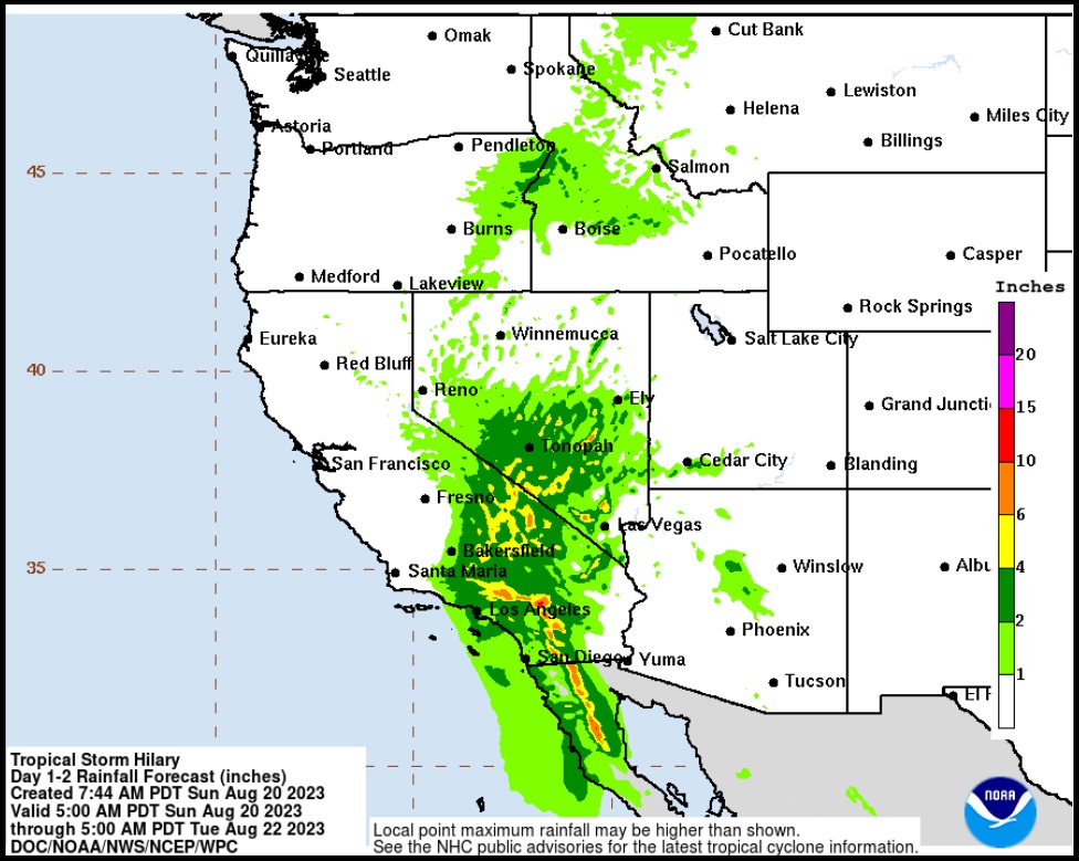
Six to ten inches of heavy rain with sustained winds of 40 mph+, with higher gusts, can create major issues for an area of hard soil that doesn’t generally get large amounts of rain in a short period of time. Washed out roads, fallen trees, flash flooding and other significant risks associated with this scale of rain are the major concern. As with most storms of this type, if you are in higher elevation areas the wind will be much stronger.
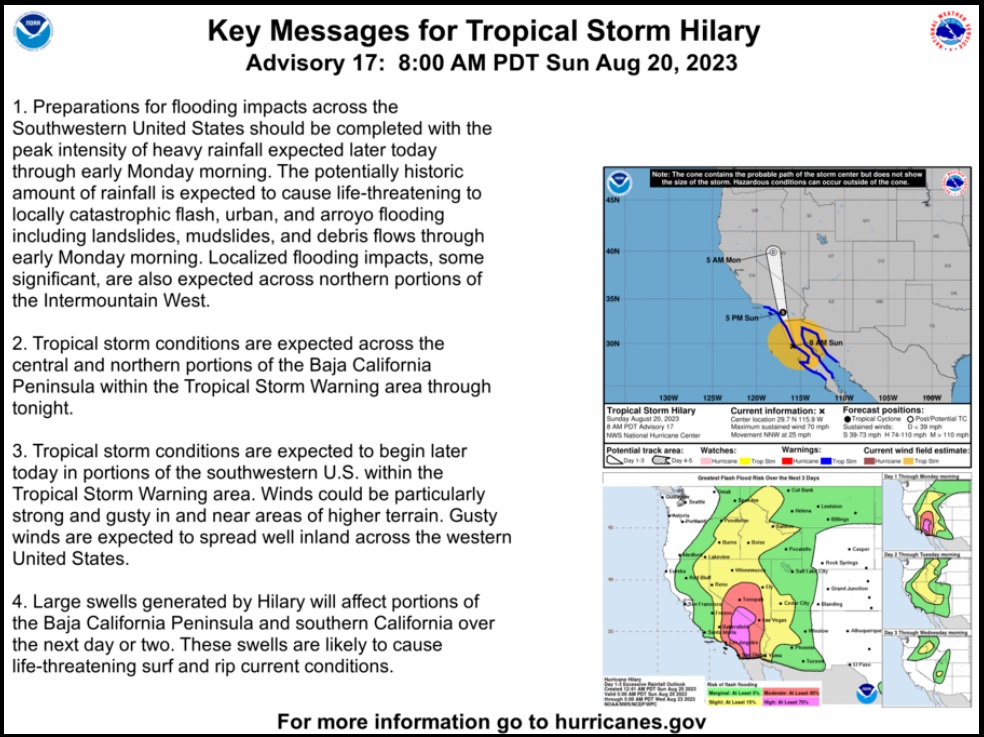
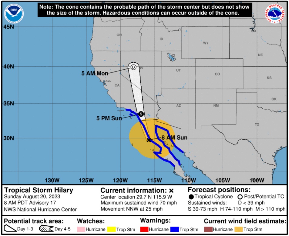
Hurricane Center – {…] At 800 AM PDT (1500 UTC), the center of Tropical Storm Hilary was located near latitude 29.7 North, longitude 115.9 West. Hilary is moving quickly toward the north-northwest near 25 mph (41 km/h). Hilary is expected to accelerate even more as it moves north-northwestward to northward during the next day or so. On the forecast track, the center of Hilary will move near or over the northern portion of the Baja California Peninsula during the next few hours, and then move across southern California this afternoon. (more)
All preparations should be completed and everyone in the zone of largest impact should remain indoors for the next 24 hours. Power failures are highly likely as the storm will knock out electricity throughout the region. [Good luck to those with EV’s] In the hours immediately following the storm, do not travel. Stay close to home as the emergency service and first responders will activate to the areas of greatest issue.
We have quite a few Treepers in this area. Check in when you can and if you need anything send us an email or drop a comment, I will be checking throughout. The biggest issue I would foresee is the potential for weakened infrastructure, roads, bridges and systems that perhaps have not encountered high pressure or stress for many years.
Always take these things seriously, but do not alarm yourself with dark imaginings. Be prudent, be wise and be safe. Focus on the immediate area around your home, pull your family in close, watch out for each other and mitigate risks from a 100-foot perspective. [If “it” (a risk or threat) is within 100′, that’s your focus.]
Fast moving, which is a good thing.
Lots of rain coming into an area that doesn’t usually get much rain…. that’s not so good.
(VIA CNN) […] Electricity utility Southern California Edison – which serves more than 15 million people in the region – said Thursday Hilary is on track to impact much of its service area. The company said it is preparing to respond to outages but urged residents to gather supplies including flashlights, external battery chargers and ice chests.
Additionally, roadways may be closed “proactively” out of an abundance of caution to ensure safety, according to Tony Tavares, director of the Department of Transportation.
[…] Brian Ferguson, deputy director of the Office of Emergency Services, told CNN Saturday the office is “all hands on deck” for Hurricane Hilary preparation. He said the office is particularly monitoring desert regions as they prepare for heavy rainfall and potential flooding.
“We’re keeping a very close eye on our desert regions, east of San Diego and Los Angeles. Some parts of these areas may receive double their yearly amount of water in just a single day,” he said. “Certainly, we are going to be watching very carefully for flash floods, mudslides and debris flows in that area, looking at the burn scars from fires that have happened in recent years.”
The San Bernardino County Sheriff’s department issued an evacuation warning for the communities of Oak Glen, Forest Falls, Mountain Home Village, Angelus Oaks, and Northeast Yucaipa. Visitors to Catalina Island, as well as residents with medical, access and functional needs, were “strongly encouraged” to leave the island ahead of the storm in a news release from the City of Avalon. (more)

“Hilary” was a perfect name for it. Big hype, little whimper. I be the earthquake had greater impact than the storm. Now we have to deal with claims of Mexico Collusion for the next four years.
Update. North San Diego county.
Still raining, had some good wind (15-17 MPH with 30-35 gusts) but really just a nice rain storm.
Exactly. Same here in South Bay of LA county at the beach …
a couple of notes:
heavy rain and flooding CAN cause power outages. Be prepared with the usual ready to eat food items and flashlights, generators, just in case. Use this time to prepare and prep your gear and test them out.
even power is interrupted, there can be a temporary delay in normal supply chain systems. anticipate this by having all of the food water and other items just in case there are temporary shortages.
if you can avoid driving during this storm, please do. With heavy rains and flooding, you can expect to see many crashes and emergency situations, as well as long delays in travel.
Now is a good time to meet you neighbors and reintroduce yourself and to promote neighborhood awareness and even threat watches. Criminals love to take advantage of natural disasters.
a simple cheap solar powered or crank power weather band radio is a good investment. the media is not generally the most reliable and effective in communicating weather. There is no overhead and “noise” in the weather band radio freqs. It’s 24/7 and regional to YOU. You do NOT need to know which channel to tune in and at what time. You just turn it on and switch between the bands usually preselected and bang…your location is broadcast. It really helps to know certain things before a storm and obviously very useful to know post storm…like emergency resources, food, ice, temp shelter…flood, tornado watches and warnings. The thing about facebook and twitter…those things rely on devices that need electrical power. Lose electrical power and those things are not reliable. a solar powered or crank power weather band radio is a very good investment.
top off all your vehicles with fuel and all stock up on fuel containers. If the power does go out, gas stations are not going to be able to pump fuel.
know the hospitals in your area that have emergency generators….911 is going to be very busy and unreliable. Most first responders and EMT ambulances will be making decisions about triage…your problem might never get solved in a timely basis…storms change all of those expectations.
have a deck of cards, and board game. boredom sucks. When you really want people to calm down and relax, play some games and don’t get worked up.
storms, even relatively tame and tropical storms can cause a LOT of damage and have a significant impact. Houston experienced this recently (2017: hurricane harvey) and numerous times over the decades. Look at tropical storm allison, 2001 to get an idea of the scale and impact. Some neighborhoods did not have full recovered power for almost 3-4 weeks! so don’t get confused about whether it will be a hurricane…that’s just a word. it’s the flooding and water for tropical storms.
God Bless America
Ground water is good.
Part of nature’s renewal cycle.
Actually, the high-wind sandstorms we get are much more irritating than rainstorms here in this desert valley. If they come up suddenly while driving– you can’t see.🌬️
There are road closures in the Coachella Valley with a large rain event because of debris and sand all over the roads.
Flash floods are dangerous. However, removing all the “beach” (sand) off of the roads is routinely more problematic.
It’s around 6:30 am and I don’t,’t hear any traffic on the road behind where I live. That’s s unusual on a week day. Don’t know about road closures yet. I need coffee!☕
God bless everyone who is suffering with fires and everything else occurring simultaneously with our Mother Earth event! 🙏
I meant to finish with– Desert Listless Vessel– over and out! ♥️🇺🇲🙏
❤️
Al ten of them? Where the heck is Forest Falls.
Near Mt. San Gorgonio.
I-10 is closed in both directions in the Palm Springs/ Palm Desert area.
Lots of road closures. I have never heard of our school district closing before. Massive cleanup required to get things up & running.
Did it ever come?
How bizarre. It was a great little vid of piles and piles of forest debris floating down into the river.
Reminded me almost of the Log Runs they used to do in Maine back in the early 60’s, or the debris piles that came don Mt St. Helens after it blew.
Flows like that are normal in monsoon season in the desert. I imagine for people who don’t live here in the west think they are dramatic, but those of us who live out here know this is why you stay out of washes and watch where you go – it doesn’t have to be raining where you are to have these flows from rain miles away.
Yep happens every time it rains heavily in the mountains the water has to go somewhere…
People are so conditioned to think if it rains the water just soaks into the ground….nope it is supposed to go into the storm drains and culverts erected for this purpose to flow into the ocean-however bcz there is so much trash and too much water at one time they get clogged and full fast resulting in overflows.
The rivers & streams naturally receive much of the water – they will overflow with too much water in a short time. This is common sense & knowledge no0t being taught bcz its all now due to climate change.
More people less land and more concrete-its not climate change – its poor planning and too many people. .
I wonder how Lake Mead is doing?
Live Fox Feed.
OMG, water is falling from the skies. We will all be killed.
Take that, you climate change deniers.
Actually, it looks pretty calm right now. This is live feed from a local LA-Orange County viewer funded TV station:
Just like covid, the bark was far worse than the bite. Must be a Democrat thing.
Glad it was named “Hilary” – she did not even get 15 second of fame on this one.
In Malibu 9 pm wind stopped, rain continues but is lighter. It was not too bad. The earthquake a few hours ago was tiny.
It’s going on 10pm here on the very western edge of the Mojave desert, and all is well. Sure, a few of our streets look like little rivers, and my roof is leaking, but other than that I can’t complain. We still have electricity, Internet and tv. Cell phones still work. I always keep plenty of food stocked up too. Heck, we even had an earthquake today.
Update: cloudy and windy now. Rain has stopped for now, but could start again any minute. We’re still under flash flood warning, but holding up well in spite of things. ‘Nite everyone.
4:30 in the am…. all quiet now.
1.8 inches of rain… never more than 0.25 per hour…. not high winds… just a few gusts here and there.
5.1… didn’t feel it.
What next? Tsunami alert at 6 AM?
New COVID lockdowns?
Gas at 6.50 per gallon
Another Trump indictment.
The corporate propaganda machine is running out of arrows in its quiver.
FJB.
Alx Jns asserts two mangerl level fed employees in 2 different agencies corroborate your fourth point, timing is initial madates in September, growing to full status by end of year. I never used to pay attention to him; now I think I will pay attention and mentally prepare myself just in case he’s right.
It always floods in Las Vegas when it rains in the summer.
Thx, Carolyn, I don’t doubt it
I don’t have a political ax to grind, I’m just posting flooding clips I stumbled across on youtube
Who the heck is this announcer? Oh-ji CA and badge-a CA omg – these are the people others are listening to?
Ensin – neda…ugggg
yeah, almost as bad as pronouncing Buena Vista
“Byoona Vista”
huh?
Thank you for letting us know about Hilary. I have a nephew in S. California, was hoping you’d post about this storm.
This just gets Newsom federal tax dollars earlier for his non-emergency. Come to Florida and see how FEMA screwed over Ian survivors. Oh, that’s right, Florida is a red state…
CA surely needs an enema.
Here in the South Bay cities of Los Angeles County it was a nice rainstorm, that’s all. The hoopla ginned up by the media was just that, hoopla. The tropical storm was really a nothing burger. Nice rain though, we enjoyed it quite a bit …
Really just an opportunity for Governor Skinny Pants Pointy Shoes Newscum to paste his mug on the news and declare an emergency.
The real emergency is the democrats running this poor state into the ground.
👍
We live in Dana Point. Moderate rains all night (Sunday) until about 2am when they stopped. No high winds or flooding that I can see. The storm seems to veered easterly and I understand Palm Springs is getting a lot of rain etc. But our coastal area seems very lightly hit.
We’re praying for rain in the South. Burn bans and very low water in the bayous.
Same thing here in Chula Vista – it was more like a tropical sprinkling-had a little wind and a downpour late Sunday night but nothin in-between except rain. Our sidewalks were dry at 12 am. Totally over hyped and panicked most of the dopes out there.
Good news is nuisance has a while before he can start burning the state up.
The tech to kill a hurricane was around in the 70s (they only wanted weapons ofc)