Quantcast

Mississippi Death Toll Now 25 as Recovery Efforts Continue

We loaded a CERT toolbox trailer yesterday that is heading to Mississippi to assist as recovery efforts get underway.  Samaritan’s Purse is now on the ground in two locations, Rolling Fork and Armory [Register to Volunteer Here]  Any Treepers in the impact zone check in and feel free to provide updates on the ground events that relate to your area.

(Via Fox News) – Help began pouring into one of the poorest regions of the U.S. after a deadly tornado tore a path of destruction for more than an hour across a long swath of Mississippi, even as furious new storms Sunday struck across the Deep South.

At least 25 people were killed and dozens of others were injured in Mississippi as the massive storm ripped through more than a half-dozen towns late Friday. A man was also killed in Alabama after his trailer home flipped over several times.

“Everything I can see is in some state of destruction,” said Jarrod Kunze, who drove to the hard-hit Mississippi town of Rolling Fork from his home in Alabama, ready to help “in whatever capacity I’m needed.”

(more…)

Deadly Tornado Hits Mississippi Late Friday Night – Early Reports of at Least 23 Killed, Widespread Devastation

The Mississippi Emergency Management Agency (MEMA) reported earlier today that at least 23 people were killed last night as a massive tornado hit multiple small towns. Their latest statement reads, “Unfortunately, these numbers are expected to change.”  Search and recovery efforts are underway.

All Treepers in the region please check in and let us know your status in the comment section.

(Via ABC) – At least 23 people died as a “destructive” tornado and strong thunderstorms swept across Mississippi late Friday, leaving a trail of damage for more than 100 miles, local and federal authorities said.

Search and rescue operations were underway in Sharkey and Humphreys counties, Mississippi’s Emergency Management Agency said late Friday. The agency issued a series of tornado warnings in counties throughout the state.

[…] Thirteen people died in Sharkey County, Coroner Angelia Easton told ABC News, adding that she could not yet confirm their ages. Carroll County Coroner Mark Stiles said three people had died. Another two were dead in Monroe County, Coroner Alan Gurley said. Jose Watson, a Mississippi Highway Patrol trooper, said one person died in Silver City, in Humphreys County. (read more)

It looks like the town of Rolling Fork has been hit hard. Rolling Fork is a small Mississippi town of about 2,000 people in Sharkey County. It was the birthplace of the blues singer Muddy Waters and sits between the Mississippi and Yazoo rivers. Silver City also looks to have taken a direct hit and the area damage is described as catastrophic.

(more…)

Two More Bodies Recovered in Aftermath of Hurricane Ian

Their names will not make national headlines, and generally everyone has moved on, but to their families and friends Ilonka Knes and James Hurst mattered.  As CTH readers may remember, in the aftermath of Hurricane Ian we shared that many missing people would be found in the months after the storm, and unfortunately many more will likely never be found.

The body of Mrs Ilonka Knes (82) was found in the mangroves and back bay salt marsh near Fort Myers Beach and has been positively identified. The body of her husband Robert was found in the days immediately following Hurricane Ian.

Additionally, the sailboat “Good Girl” was found submerged with human remains believed to be the body of James ‘Denny’ Hurst (73).

Mrs. Knes and Mr Hurst bring the total number of Hurricane Ian victims in Lee County, Florida, to seventy-five.  Mr. Hurst was the final “official” missing person on the local list; however, there are many more yet unaccounted that were not from this immediate area.   The physical devastation is widespread, but the emotional toll on the families and friends of the missing has been beyond imagining.  Tonight, two more families have answers.

(more…)

Twelve Dead in Buffalo Due to Arctic Storm – Emergency Crews, National Guard Responding to Rescue Efforts at Airport Control Tower

Buffalo New York is known for its extreme snow and cold weather as an outcome of Lake Erie and the ‘lake effect’ snow created.  However, the current arctic storm is making even normally bad Buffalo even more dangerous.

Up to twelve people have been killed after they were trapped in their vehicles and currently rescue operations are underway at the airport to recover air traffic controllers who were stranded in the control tower.

(Reuters) – A deadly blizzard paralyzed Buffalo, New York, on Christmas Day, trapping motorists in their cars, knocking out electricity to thousands of homes and raising the death toll from a severe winter storm system that has chilled much of the United States for days.

At least 30 people have died in U.S. weather-related incidents, according to an NBC News tally, since a deep freeze gripped most of the nation, coupled with snow, ice and howling winds from a storm that roared out of the Great Lakes region late last week.

(more…)

Severe Winter Storm Brings Cold, Snow and Proactive Warnings from White House

Extreme winter weather, such as subzero temperatures, wind chills and heavy snow, is impacting much of the U.S. this Christmas holiday weekend and is expected to heavily impact travel.  Major parts of the U.S. electricity grid are very vulnerable, particularly as a result of Biden energy policy, steering investment away from coal, oil and natural gas.

Places across the northern Rockies, northern Plains and upper Midwest are experiencing temperature drops by tens of degrees in minutes.  The extremely cold airmass is expected to hit at least 24 other states along the Gulf Coast and in the eastern U.S.  The National Weather Service has a Detailed Warning HERE.

The potential for severe consequences as an outcome of this winter storm has the political minders of Joe Biden worried.

.

(Via NWS) – A major and anomalous storm system is forecast to produce a multitude of weather hazards through early this weekend, as heavy snowfall, strong winds, and dangerously cold temperatures span from the northern Great Basin through the Plains, Upper Midwest, Great Lakes, and the northern/central Appalachians.

At the forefront of the impressive weather pattern is a dangerous and record-breaking cold air mass in the wake of a strong arctic cold front diving southward across the southern Plains today and eastward into the Ohio/Tennessee Valleys by tonight.

(more…)

Hurricane Nicole Expected to Impact Southeast, Southcentral Coast and Central Florida Overnight

Hurricane conditions are expected from Boca Raton to Flagler/Volusia County line along the coast in Florida tonight.  However, do not focus only on the center of the storm. Hurricane winds extend 25 miles from center, tropical storm winds 400+ miles from center, and massive rain are anticipated over central Florida with significant flooding north of Lake O.  Residents along coastal and inland waterways should be fully prepared for this storm.  Overnight conditions will deteriorate rapidly.

At 1000 PM EST (0300 UTC), the center of Hurricane Nicole was located near latitude 27.0 North, longitude 78.9 West. Nicole is moving toward the west-northwest near 13 mph (20 km/h). A turn toward the northwest is expected on Thursday, followed by a turn toward the north and north-northeast on Friday.

On the forecast track, the center of Nicole will move onshore the east coast of Florida within the hurricane warning area late tonight or early Thursday. Nicole’s center is then expected to move across central and northern Florida into southern Georgia Thursday and Thursday night, and into the Carolinas Friday.

(more…)

UPDATE – East Coast Florida Residents Prepare for Arrival of TS Nicole at Hurricane Status

While all attention is on the outcome of the national election, a storm notice for Florida is essential.

The National Hurricane Center is advising Florida east coast residents to prepare for hurricane conditions during the Wednesday overnight hours. [NHC Website]  Tropical Storm Nicole is moving quickly toward the Bahamas and will approach the Florida east coast late Wednesday.   Florida Governor Ron DeSantis has declared a state of emergency to release resources and trigger support mechanisms.

All Florida east coast residents should pay attention to local officials and state emergency management for guidance in advance of Nicole’s arrival.  All storm preparation should be rushed to completion within the next several hours.  Nicole is anticipated to deliver storm impacts far beyond the immediate hurricane zone.

(Nation Hurricane Center) At 1000 AM EST (1500 UTC), the center of Tropical Storm Nicole was located near latitude 26.5 North, longitude 76.7 West. Nicole is moving toward the west near 12 mph (19 km/h). A turn toward the west-northwest is expected tonight, followed by a turn toward the northwest on Thursday, and north or north-northeast on Friday.

On the forecast track, the center of Nicole will move near or over the Abacos and Grand Bahama in the northwestern Bahamas today and move onshore the east coast of Florida within the hurricane warning area tonight. Nicole’s center is then expected to move across central and northern Florida into southern Georgia Thursday and Thursday night, and then across the Carolinas Friday and Friday night.

(more…)

TS Nicole Likely to Become a Hurricane as Storm Approaches Florida East Coast Wednesday Night

The National Hurricane Center is advising Florida east coast residents to prepare for hurricane conditions during the Wednesday overnight hours. [NHC Website]  Tropical Storm Nicole is moving quickly toward the Bahamas and will approach the Florida east coast late Wednesday.   Florida Governor Ron DeSantis has declared a state of emergency to release resources and trigger support mechanisms.

[NOTE: Florida West Coast – Nicole is a large system with tropical storm force winds extending for 380 miles from center.  For SWFL residents in the debris and recovery zone from Ian, the winds from Nicole will be coming from the North, starting soon. Keep this in mind when securing already destabilized structures, roof tarps, fences, debris etc. Anticipate tropical storm force winds arriving from the North tomorrow.]

(NHC) At 1000 AM EST (1500 UTC), the center of Tropical Storm Nicole was located near latitude 27.8 North, longitude 72.7 West. Nicole is moving toward the west near 9 mph (15 km/h). A west to west-southwest motion should continue through Wednesday. A west-northwest motion is forecast to begin on Wednesday night, followed by a turn toward the northwest and north-northwest on Thursday and Thursday night.

On the forecast track, the center of Nicole will approach the northwestern Bahamas today and tonight, move near or over those islands on Wednesday, and approach the east coast of Florida within the hurricane warning area Wednesday night. Nicole’s center is then expected to move across central and northern Florida into southern Georgia Thursday and Thursday night.

Maximum sustained winds are near 50 mph (85 km/h) with higher gusts. Strengthening is expected during the next 36 to 48 hours, and Nicole is forecast to be near or at hurricane strength by Wednesday and Wednesday night while it is moving near the northwestern Bahamas and approaching the east coast of Florida. (more)

The majority of my advice below is for the Florida EAST COAST:

(more…)

Head’s Up, STS Nicole Anticipated to Be Hurricane as it Approaches Florida Southeast Coastline – All Coastal Areas, Including GA, Be Advised

There are only two words that come to mind as I write this notice from the Ian impact zone, “mercy” and “uncle.”  Prayers.

STS Nicole is anticipated to become a Cat-1 Hurricane as it approaches the southeast coast of Florida late Wednesday night. A Hurricane warning is in effect for the Northeast Bahamas, and a Hurricane Watch is in effect for the East Coast of Florida from the Volusia/Brevard County Line to Hallandale Beach. Residents along the Florida east coast should watch for updates [Hurricane Center Link].

If you are on the east coast of Florida, you should begin preparations today and tomorrow for the potential of high winds, power outages, coastal storm surge and inland flooding.  Georgia and South Carolina should also keep an eye on this.

Additionally, on the other side of the state, while Nicole is not anticipated to be a strong hurricane and will hopefully lose strength quickly as it moves over land, any tropical storm winds and rain along the southwest Florida areas (SWFL) previously impacted by Ian could be very troublesome.  Everything is tenuously held together in SWFL and there is massive debris and structural instability present as recovery efforts continue.  This is not good.

(NHC) – At 400 PM EST (2100 UTC), the center of Subtropical Storm Nicole was located near latitude 26.6 North, longitude 70.6 West. The storm is moving toward the northwest near 9 mph (15 km/h). A slower northwestward motion is expected tonight. A turn toward the west or west-southwest is forecast to begin by Tuesday night and that motion should continue through early Thursday. On the forecast track, the center of Nicole will approach the northwestern Bahamas on Tuesday and Tuesday night, move near or over those islands on Wednesday, and approach the east coast of Florida Wednesday night. (more)

(more…)

Part I, Lessons from Hurricane Ian – The Context

Many CTH readers know I have been involved in hurricane prep and recovery as a longtime member of a civilian emergency response team.  I have physically been through four direct hurricane impacts and responded to recovery efforts in more than fifteen locations, often staying for days or weeks after the initial event.

Through the years I have advised readers on best practices for events before, during and after the storm. In this outline my goal is to take the experience from Hurricane Ian and overlay what worked and what doesn’t work from a perspective of the worst-case scenario.

Hurricane Ian was a worst-case scenario.

Let me be clear from the outset, I am not advising anyone to put greater weight on my opinion or ignore local emergency officials or professionals in/around the disaster areas. What I am going to provide below is my own experience after decades of this stuff, against the backdrop of Ian, and just provide information that you may wish to consider if you are ever faced with a similar situation.

Hurricane preparation can be overlaid against other types of disaster preparation, there are some commonalities.  However, for the sake of those who live on/around the U.S. coastal areas where hurricanes have traditionally made impact, the specifics of preparation for this type of storm are more pertinent.  I’m going to skip over the basic hurricane preparation and get into more obscure and granular details, actual stuff that matters, that many may not be familiar with.

Let me start by sharing a graphic that you may overlay with the information you may have already seen from national media coverage.  The graphic below shows Hurricane Ian in relation to Southwest Florida and points to locations that you may have seen on the news.  The context of understanding Ian is going to be critical when contemplating preparation, so it must be emphasized.

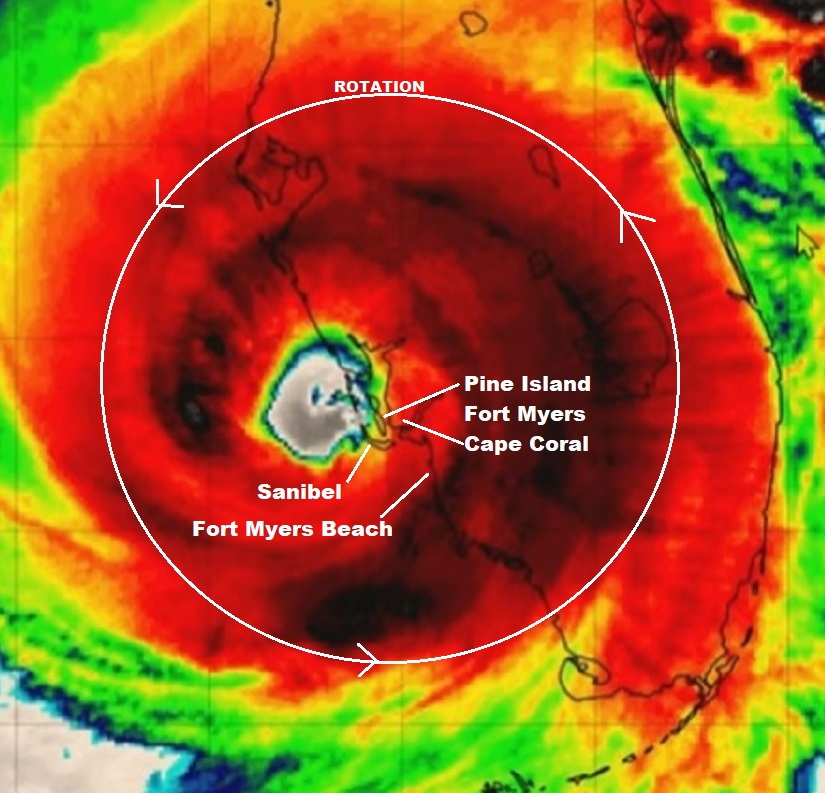
This satellite image was likely taken around 4 to 7 pm on the evening of September 28, 2022, approximately three hours after Hurricane Ian officially made landfall at Bokeelia, a small community on the Northern end of Pine Island. All of my discussion below is from the ‘major impact zone’.

(more…)