Quantcast

Hurricane Ian Projected Path Narrows, Local SWFL Radar Now Tracking – All Preparations Need to be Rushed to Completion

The projected path of Hurricane Ian, a category 4 storm, has now been narrowed.  Landfall is anticipated just North of Cape Coral in the Punta Gorda, Port Charlotte area.  Lee and Charlotte counties will likely feel greatest impact from Ian starting overnight through all day Wednesday, with eyewall entering Southwest Florida (SWFL) overnight Wednesday.

All preparations must be rushed to completion.  Power outages will likely start sporadically happening early to midday tomorrow (Wed).  Evacuation zones have been expanded due to increased storm surge prediction.  Pay close attention to your local officials and local media.  If you are staying in the Lee or Charlotte coastal area, now is the time to finish inside preparations.  Local SWFL radar is now tracking storm [Local Media Link].

Boca Grande Pass, famous for exceptional Tarpon fishing, looks to be the immediate coastal area where the greatest wind driven storm surge will impact.   Gulf water will be pushed up the Caloosahatchee and Peace rivers creating expanded flooding further inland.  The flooding and storm are anticipated to be the largest in SWFL history and are the greatest risk.

(NHC) – Maximum sustained winds remain near 120 mph (195 km/h) with higher gusts. Ian is a category 3 hurricane on the Saffir-Simpson Hurricane Wind Scale. Re-strengthening is expected later today through Wednesday. Ian is forecast to approach the west coast of Florida as an extremely dangerous major hurricane. Hurricane-force winds extend outward up to 40 miles (65 km) from the center. (more)


(more…)

11am Hurricane Ian Update – Florida West Coast Finalize Preparations Now, Listen Closely to Officials for Coastal Evacuation Zones

[National Hurricane Center Data]  As of 11:00am ET Tuesday, Hurricane Ian has maximum sustained winds of 115 mph [Category 3].  Ian is anticipated to continue strengthening in the next 24 hours as it enters the Gulf of Mexico as a major hurricane [Cat 3+].  All west coast Florida residents from Bonita Springs to Tampa should use Today to finalize their hurricane preparations.

Today is the last good weather day to finish your preparations and secure your property.  Do not be alarmed but do take this hurricane seriously. This is not a ‘wait and see’ type storm.  All reasonable precautions should be completed today, and all coastal residents are urged to pay close attention to local officials for evacuation orders.  Each locality is different, each coastal locality has a zone of potential flooding and storm surge.  As a general rule, hunker down from wind – but evacuate from water.

[NHC] At 1100 AM EDT (1500 UTC), the center of Hurricane Ian was located near latitude 23.0 North, longitude 83.5 West. Ian is moving toward the north near 10 mph (17 km/h), and this motion is expected to continue today. A turn toward the north-northeast with a reduction in forward speed is forecast tonight and Wednesday. On the forecast track, the center of Ian is expected to move over the southeastern Gulf of Mexico in a couple of hours, pass west of the Florida Keys later today, and approach the west coast of Florida within the hurricane warning area on Wednesday and Wednesday night. (more)

Official projections now put the storm further east and slightly south, just off the Florida southwest coast on Wednesday night, with the potential for a 24-hour duration cycle. That is an alarming amount of time for a major hurricane to be centered near or on the coast.  That is a minimum of two tidal cycles, which will make a big difference from prior hurricanes in terms of flooding and the potential for a historic storm surge into inland waterways.

(more…)

September 27th – 2022 Presidential Politics – Resistance Day 616

In an effort to keep the Daily Open Thread a little more open topic we are going to start a new daily thread for “Presidential Politics”. Please use this thread to post anything relating to the JoeBama Administration and Presidency.

“This is no small thing, to restore a republic after it has fallen into corruption. I have studied history for years and I cannot recall it ever happening. It may be that our task is impossible. Yet, if we do not try then how will we know it can’t be done? And if we do not try, it most certainly won’t be done. The Founders’ Republic, and the larger war for western civilization, will be lost.”

“But I tell you this: We will not go gently into that bloody collectivist good night. Indeed, we will make with our defiance such a sound as ALL history from that day forward will be forced to note, even if they despise us in the writing of it.”

~ Mike Vanderboegh

This thread will refresh daily and appear above the Open Discussion Thread.

(more…)

Tuesday September 27th – Open Thread

Our Father, who art in heaven, hallowed be thy Name. Thy kingdom come. THY WILL BE DONE, on earth as it is in heaven. Give us this day our daily bread. And forgive us our trespasses, as we forgive those who trespass against us. And lead us not into temptation, but DELIVER US FROM EVIL.
For Thine is the kingdom and the power and the glory, forever and ever. Amen †

(more…)

Hurricane Ian Update 11pm, West Coast Florida Residents Complete Preparation Tuesday Without Delay, Coastal Residents Pay Attention to Local Officials For Evacuation Orders

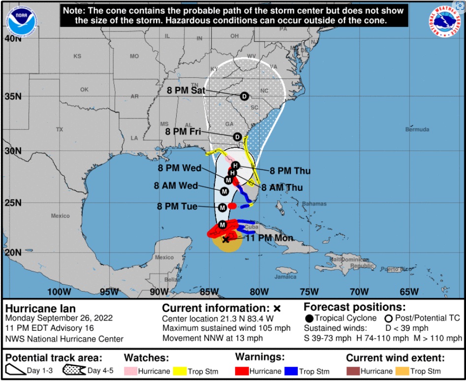
[National Hurricane Center Data]  As of 11:00pm ET Monday, Hurricane Ian has maximum sustained winds of 105 mph [Category 2].  Ian is anticipated to strengthen rapidly in the next 24 hours as it enters the Gulf of Mexico as a major hurricane [Cat 3+].  All west coast Florida residents from Bonita Springs to Tampa should use Tuesday to finalize their hurricane preparations.

Tuesday is the last good weather day to finish your preparations and secure your property.  Do not be alarmed but do take this hurricane seriously. This is not a ‘wait and see’ type storm.  All reasonable precautions should be completed today, and all coastal residents are urged to pay close attention to local officials for any evacuation orders.  Each locality is different, each coastal locality has a zone of potential flooding and storm surge.  As a general rule, hunker down from wind – but evacuate from water.

Official projections put the storm just off the Florida west coast on Wednesday night, with the potential for a 24-hour duration cycle. That is an alarming amount of time for a major hurricane to be centered near or on the coast.  That is a minimum of two tidal cycles, which will make a big difference from prior hurricanes in terms of flooding and the potential for a historic storm surge into inland waterways.

Hurricanes can be frightening; downright scary. There’s nothing quite like going through a few to reset your outlook on just how Mother Nature can deliver a cleansing cycle to an entire geographic region.  If this storm rests on/near the coast for the projected duration (24 hrs), things could be much more sketchy than other hurricanes.  This possibility is not something to dismiss.  No one in Florida has a reference.

(more…)

Canada Scheduled to End Vaccination Border Requirements October 1st

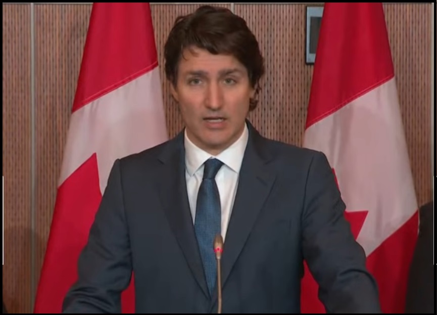
New Zealand, Australia and Canada retained the most restrictive policies on vaccination the longest. However, today Canada announced they are finally loosening the totalitarian fiats and permitting travelers to enter the country without proof of vaccination.

New measures begin October 1st.

(The Hill) — Canada is lifting its testing, quarantine and vaccination requirements at the border, a step in rolling back pandemic restrictions designed to stave off the spread of COVID-19, the government announced Monday.

Starting Oct. 1, international travelers will be able to enter Canada without providing proof of vaccination, taking a pre-arrival test or undergoing quarantine, according to a government release. Compulsory masking on domestic planes and trains will also end, as will a longstanding requirement to share health information with the Canadian government via its ArriveCAN application prior to entry.

The move comes as many countries attempt to ease out of the strict restrictions put in place during the COVID-19 pandemic even as the virus continues to circulate. (read more)

(more…)

Florida Governor Ron DeSantis Gives Update on West Coast of Florida Evacuation Plans

With the forecasted path of Hurricane Ian anticipated to bring high water and winds to the west coast of Florida there is the potential for major storm surge in specific regions. Florida Governor Ron DeSantis held a press conference from Pinellas County to outline the latest information. WATCH: 

 ~ Florida Disaster Website as Outlined ~

TALLAHASSEE, Fla. — This morning, Governor Ron DeSantis issued updates on Hurricane Ian at the State Emergency Operations Center with Florida Division of Emergency Management Director Kevin Guthrie. Full remarks from this morning’s press conference are available here.

(more…)

Update, Hurricane Ian Starts Northward Shift – Expected to Become Major Hurricane Tonight, West Coast of Florida Prepare

[National Hurricane Center Link]  Ian is now a hurricane and expected to intensify quickly tonight and tomorrow exiting the Caribbean into the Gulf of Mexico as a major hurricane.  Cone of probability for landfall arrival in the U.S. is still fluctuating. However, all west coast Florida residents should be finalizing their preparations today and tomorrow.  Our chainsaws are sharpened, gear packed, toolboxes loaded. Today, we finish securing our property.

As a general rule, take cover from wind – but evacuate away from water.  Dangerous coastal area storm surges are now predicted from Fort Myers north into Tampa Bay (south side of storm).  Please outline your communication plan with your family.  Select a specific person outside the area to be your immediate contact. That person then relays information to the rest of your family.  Please do this [Example Why].

At 1100 AM EDT (1500 UTC), the center of Hurricane Ian was located near latitude 19.1 North, longitude 82.7 West. Ian is moving toward the northwest near 13 mph (20 km/h). A north-northwestward motion is expected to begin later today, followed by a northward motion on Tuesday with a slightly slower forward speed. A turn toward the north-northeast with a further reduction in forward speed is forecast on Wednesday. On the forecast track, the center of Ian is expected to pass near or west of the Cayman Islands today, and near or over western Cuba tonight and early Tuesday. Ian will then emerge over the southeastern Gulf of Mexico on Tuesday, pass west of the Florida Keys late Tuesday, and approach the west coast of Florida on Wednesday into Thursday. (link)

Right now, you are in control.  Do not be alarmed – but take every preventative measure your individual situation needs.  Work your hurricane plan and stay focused on what you do control.  Proactive planning prevents piss-poor performance. Work the plan, step by step and focus on what is in front of you.  Ignore the dark imaginings and turn off the national media.  Pay attention to your local officials and local media.

Do your laundry. Sanitize and stage your water storage.  Inventory your supplies.  Organize your tools.  Fill your freezer with water jugs to take up room and freeze.  Test your generator. Stage your extension cords. Stage your battery powered devices. Test your weather radio. Take small steps to prepare.  Secure your home. You are in full control.

(more…)

September 26th – 2022 Presidential Politics – Resistance Day 615

In an effort to keep the Daily Open Thread a little more open topic we are going to start a new daily thread for “Presidential Politics”. Please use this thread to post anything relating to the JoeBama Administration and Presidency.

“This is no small thing, to restore a republic after it has fallen into corruption. I have studied history for years and I cannot recall it ever happening. It may be that our task is impossible. Yet, if we do not try then how will we know it can’t be done? And if we do not try, it most certainly won’t be done. The Founders’ Republic, and the larger war for western civilization, will be lost.”

“But I tell you this: We will not go gently into that bloody collectivist good night. Indeed, we will make with our defiance such a sound as ALL history from that day forward will be forced to note, even if they despise us in the writing of it.”

~ Mike Vanderboegh

This thread will refresh daily and appear above the Open Discussion Thread.

(more…)

Monday September 26th – Open Thread

Our Father, who art in heaven, hallowed be thy Name. Thy kingdom come. THY WILL BE DONE, on earth as it is in heaven. Give us this day our daily bread. And forgive us our trespasses, as we forgive those who trespass against us. And lead us not into temptation, but DELIVER US FROM EVIL.

For Thine is the kingdom and the power and the glory, forever and ever. Amen †

(more…)