Quantcast

Hurricane Helene Leaves Wake of Destruction and Ongoing Flooding

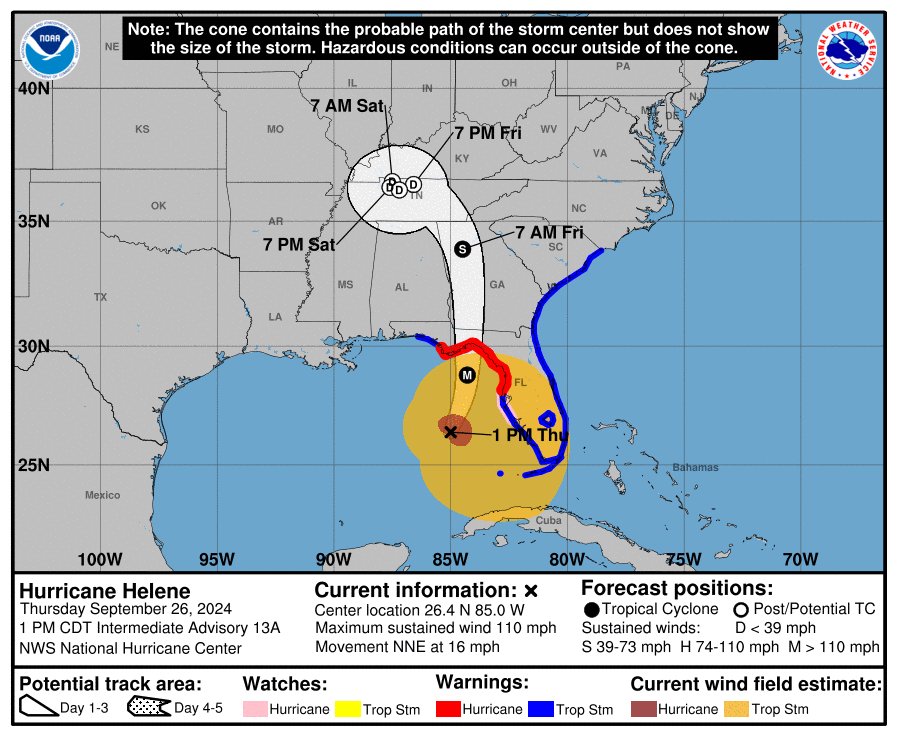
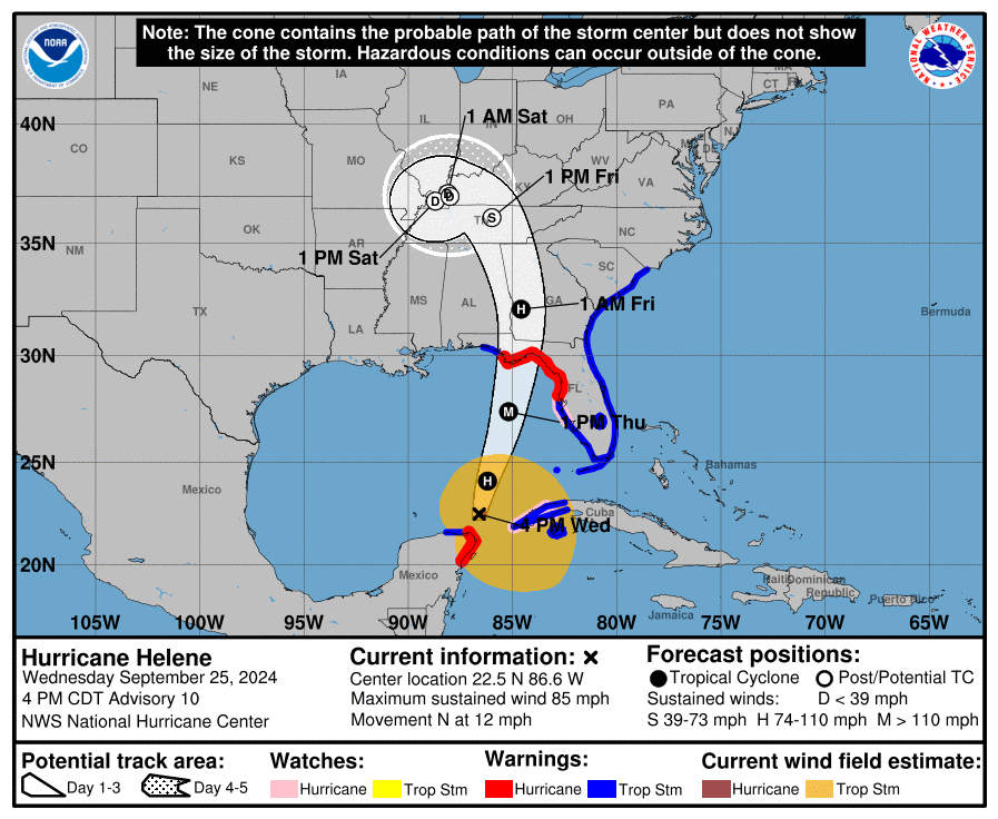
Flooding and high water continue being a serious problem as former Hurricane Helene dumps massive amounts of rain.

Fast moving Helene made landfall about 10 miles west-southwest of Perry, Florida, at 11:10 pm last evening. Helene came ashore as a Cat-4 storm with over 120 mph sustained winds.  Seven fatalities have been reported. Following the storm surge, impacts are now being felt across the Southeast and into portions of the mid-Atlantic as the storm pushes farther inland and weakens.

The greatest ongoing threat from Helene’s activity continues to be flash flooding as torrential rain falls throughout the southeast, impacting rivers and pushing streams onto roads and into communities, sometimes trapping residents.

According to Fox News Weather, “The flash flood threat stretches from the Southeast into the mid-Atlantic, where multiple Flash Flood Emergencies were issued early Friday morning, including the first-ever Flash Flood Emergency issued for Atlanta.

At least seven other Flash Flood Emergencies were also issued in western North Carolina from Asheville to the Charlotte area.

According to a post on X from Haywood County Emergency Services, residents in portions of Waynesville, North Carolina, are being told to evacuate because of the potentially deadly situation that’s unfolding. (more)

Treepers in the affected areas, please use this thread to update your personal condition.  Also, all long time Treepers understand you can reach out via email if you need assistance, and we will do our earnest best to assist and/or connect you with resources.

1,500 search and rescue responders are active right now just in Florida.  If you are in an impact zone, do not go looking around, be careful.  There is a great video below, a press conference from moments ago, that contains excellent information for those in the impact zone.  Please watch it.

(more…)

Hurricane Helene Strengthens and Advances on Predicted Course

Hurricane Helene is following the forecast track.  SW Florida is feeling the impact of the first storm surge.  Tropical storm force winds are being felt throughout Florida. All interests in the Big Bend area should heed local officials’ warnings and instructions.  Focus on the local emergency management advice.

For those who are in the path of the storm, there comes a time when all options are removed, and you enter the “Hunkering Down” phase. You’re just about there now.  Hurricane force winds extend 60 miles from center.

At 100 PM CDT (1800 UTC), the center of Hurricane Helene was located near latitude 26.4 North, longitude 85.0 West. Helene is moving toward the north-northeast near 16 mph (26 km/h). A significant increase in forward speed is expected during the next 24 hours. On the forecast track, Helene will make landfall in the Florida Big Bend region this evening. After landfall, Helene is expected to turn northwestward and slow down over the Tennessee Valley on Friday and Saturday.

Maximum sustained winds have increased to near 110 mph (175 km/h) with higher gusts. Additional strengthening is forecast, and Helene is expected to be a major hurricane when it reaches the Florida Big Bend coast this evening. Weakening is expected after landfall, but Helene’s fast forward speed will allow strong, damaging winds, especially in gusts, to penetrate well inland across the southeastern United States, including over the higher terrain of the southern Appalachians.

Helene is a very large hurricane. Hurricane-force winds extend outward up to 60 miles (95 km) from the center and tropical-storm-force winds extend outward up to 345 miles (555 km). (link)

(more…)

Hurricane Helene Intensifies as Forecast Path Narrows – Complete Preparation Now

The National Hurricane Center is narrowing the forecast path of Hurricane Helene, while strongly emphasizing the importance of preparation for a dangerous storm impact in the Florida panhandle region.  Everyone in the area should pay close attention.

Helene is anticipated to intensify tomorrow and start moving forward very quickly.  This can push the wind driven water very severely into the upper Florida coastal area.  The storm surge is anticipated to be very dangerous.  Evacuations are beginning and all preparation should be rushed to completion. [NHC Center Here]

At 400 PM CDT (2100 UTC), the center of Hurricane Helene was located near latitude 22.5 North, longitude 86.6 West. Helene is moving toward the north near 12 mph (19 km/h). A northward or north-northeastward motion at a faster forward speed is expected during the next 36 hours. On the forecast track, Helene will move across the eastern Gulf of Mexico tonight and Thursday and cross the Florida Big Bend coast Thursday evening. After landfall, Helene is expected to turn northwestward and slow down over the Tennessee Valley on Friday and Saturday.

Maximum sustained winds are near 85 mph (140 km/h) with higher gusts. Strengthening is forecast, and Helene is expected to be a major hurricane when it reaches the Florida Big Bend coast Thursday evening. Weakening is expected after landfall, but Helene’s fast forward speed will allow strong, damaging winds, especially in gusts, to penetrate well inland across the southeastern United States, including over the higher terrain of the southern Appalachians. (read more)

Fortunately, the eyewall -the area of strongest winds- is likely to be tight and small; however, the outflow wind field is likely to be very large which makes the water pushing into the coastal region more concerning.

(more…)

UPDATE: Florida Governor Ron DeSantis Urges Preparation in Advance of Likely Hurricane Helene

The National Hurricane Center has provided a 5:00pm ET update. [SEE HERE]

At 500 PM EDT (2100 UTC), the center of Tropical Storm Helene was located near latitude 19.7 North, longitude 84.7 West. Helene is moving toward the west-northwest near 12 mph (19 km/h). A turn toward the northwest is expected tonight, followed by a general northward motion beginning on Wednesday and continuing through Friday. On the forecast track, the center of Helene will pass near the northeastern coast of the Yucatan Peninsula on Wednesday, move across the eastern Gulf of Mexico on Wednesday and Thursday, and reach the Big Bend coast of Florida late Thursday.

Maximum sustained winds have increased to near 50 mph (85 km/h) with higher gusts. Additional strengthening is forecast, and Helene is expected to become a hurricane on Wednesday. The storm is forecast to rapidly strengthen over the eastern Gulf of Mexico and become a major hurricane on Thursday. (link)

There are many variables still present within the models for the track of TS Helene as it develops and strengthens into a hurricane.  Essentially, the largest variable is the intensity of the storm as it approaches the coastline.   There are significant variables; however, everyone should prepare for the worst scenario and then adjust with additional information as it is provided.

It is very important to pay attention to your local officials and emergency management teams.  Each area is very different, and each community can feel a totally different impact depending on topographical, geographical and regional distinctions.  Listen to state officials, pay attention to the National Hurricane experts, but the best suggestion is to focus your attention on the advice of local EMS officials.

Florida Governor Ron DeSantis provided a press briefing earlier today (below).

(more…)

FL Governor DeSantis Declares a Proactive State of Emergency Ahead of Potential Hurricane Helene

Those in the area of Sarasota, Clearwater/St Pete to the Florida Panhandle and Big Bend area need to pay particular attention to the path of this storm throughout the day today and tomorrow. An area of extreme weather is expected to become hurricane Helene very quickly.

There is a potential for strength to major hurricane status in the Gulf of Mexico prior to landfall. Those in the Mississippi and Alabama coastal area should also keep an eye for updates.

At 800 PM EDT (0000 UTC), the disturbance was centered near latitude 18.3 North, longitude 82.3 West. The system is moving toward the north-northwest near 7 mph (11 km/h). A northwestward motion is expected on Tuesday and Tuesday night, followed by a faster northward to north-northeastward motion on Wednesday and Thursday.

On the forecast track, the center of the system is forecast to move across the northwestern Caribbean Sea through Tuesday night, and then over the eastern Gulf of Mexico on Wednesday and Thursday. (link)

Hurricane Ian hit the Florida SW coast on Sept 29, 2022.  September hurricanes are strong, the Gulf of Mexico is very warm.

For those in the cone of uncertainty, remember, planning and proactive measures taken now can significantly reduce stress in the days ahead. Plan when to make the best decision on any evacuation (if needed) consider Tuesday night the decision timeframe. As a general rule: take cover from wind – but evacuate away from water.

(more…)