
As many long-time readers will know, we do have a little bit more than average experience dealing with the aftermath of hurricanes. I am not an expert in the before part; you need to heed the local, very local, professionals who will guide you through any preparation, and neighborhood specific guidelines, for your immediate area.
But when it comes to the ‘after part’, well, as a long-time CERT recovery member perhaps I can guide you through the expectation and you might find some value.
Consider this little word salad a buffet. If you are new to Florida hurricanes, absorb what might be of value pass over anything else.
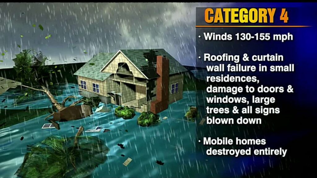 A category-4 storm can and will erase structures, buildings and landscape.
Hurricane Ian is similar to Hurricane Charley which impacted the SW coast of Florida in 2004, only a longer duration and therefore worse. The coastal topography and barrier islands will likely change in the 40-mile-wide area of immediate impact.
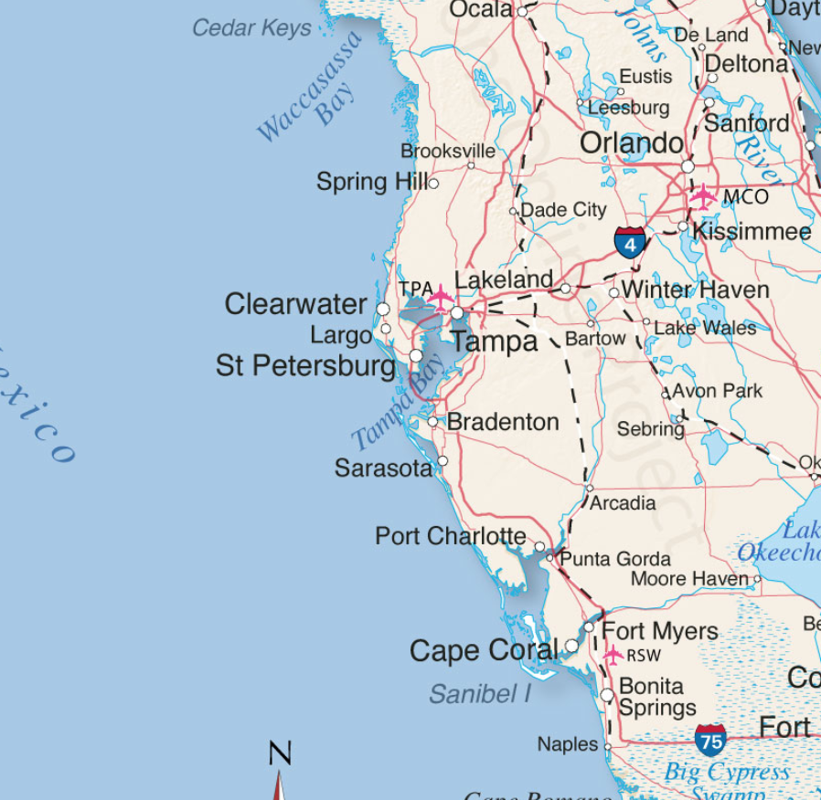
Sanibel Island, Bonita Beach, Fort Myers Beach, Captiva, Upper Captiva, Boca Grande, Pine Island, Cape Coral, Siesta Key, Longboat Key, Charlotte Harbor and Pine Island Sound could all be impacted.
There is the potential for 18+ hours of hurricane force winds and two tides with storm surges. Total infrastructure failure should be anticipated, and it will take weeks for restoration. The coastal communities are the most vulnerable; however, the inland impact of the storm will continue unimpeded until the eyewall crosses onto land.
That means communities inland for roughly 50 miles could likely see consistent hurricane force winds for several hours. That scale of sustained wind energy will snap power poles and weaken reinforced concrete.
As the backside of the storm then reverses the energy direction, any already compromised structures will not withstand the additional pressure. In many cases the backside of the storm is worse than the front. If you are inland, you too should prepare yourself for long duration of extensive wind damage followed by an extended power outage.
For those who are in the path of the storm, there comes a time when all options are removed, and you enter the “Hunkering Down” phase. You’re there now.
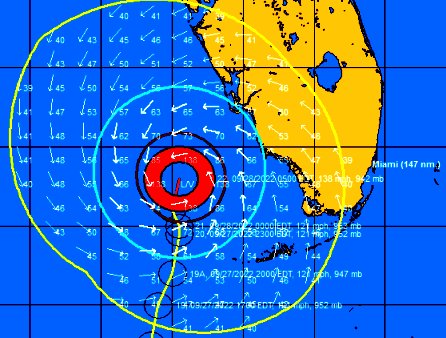
Ian is forecast to approach the west coast of Florida as an extremely dangerous major hurricane. Hurricane-force winds extend outward up to 40 miles (65 km) from the center and tropical-storm-force winds extend outward up to 140 miles (220 km). (link)

Unfortunately, unlike Charley, this particular hurricane Ian will stick around for more than the 2+ hours of the 2004 storm event. That brings a serious problem with coastal storm surge (two tidal cycles). In its totality from initial impact through recovery this is going to be a long-duration event.
When the sustained winds reach around 45mph only the more dire of emergencies get an immediate response. It is almost a guarantee that around the time emergency responders stop responding, too dangerous, you will lose power from the storm. Do not expect the power to be turned back on until it is safe, in this example recovery will be delayed by the slow forward progress of the storm.
Hurricanes can be frightening; downright scary. There’s nothing quite like going through a few to reset your outlook on just how Mother Nature can deliver a cleansing cycle to an entire geographic region. The sounds are scary. Try to stay calm despite the nervousness. Telephone and power poles, yes, even the concrete ones, can, and likely will, snap like toothpicks.
The ground in Southwest Florida is also completely saturated with heavy rains even before the storm began dumping water earlier on Monday. Trees that previously withstood Irma and even Charley, could likely bend, uproot and break; the sounds are dramatic.
There’s a specific sound when you are inside a hurricane that you can never forget. It isn’t a howl, it’s a roar. It is very unique sound in depth and weight. Yes, within a hurricane wind has weight. Stay clear of windows and doors, and within an interior room of the house or apartment if possible.
That scary roar will sound like it will never quit, especially for this specific slow-moving hurricane. It will stop, eventually; but at the time you are hunkering down, it doesn’t seem like it will ever end. This is the part that makes people say they will never go through that again. It is intensely unnerving. Imagine being impacted by a tornado for a full day.
A hurricane wind is a constant and pure rage of wind that doesn’t ebb and flow like normal wind and storms.
Hurricane wind is heavy, it starts, builds and stays, sometimes for hours. This one is forecast to be the longest in my memory. The wind is relentless, it just seems like it won’t let up. And then, depending on Ian’s irrelevant opinion toward your insignificant presence, it will stop.
Judging by the forward speed being stated by professionals at the National Hurricane Center, the hurricane force wind will likely last around 18 hours before it stops. Prepare your nerves as best you can for this.
Then silence. No birds. No frogs. No crickets. No sound.
Nature goes mute. It’s weird.
We have no idea how much ambient noise is around us, until it stops.
 Due to the speed of this storm, there will be convoys coming to construct a pre-planned electricity grid recovery process around nightfall Thursday. Convoys from every city, town and state from the east-coast to the mid-west. A glorious melding of dirty fingernails all arriving for the meet-up. Depending on your proximity to the bigger picture objectives at hand, you will cherish their arrival.
But first, there will be an assessment. The convoys will stage at pre-determined locations using radios for communication. Most cell phone services will likely be knocked out. Recovery teams will begin a street-by-street review; everything needs to be evaluated prior to thinking about beginning to rebuild a grid. Your patience within this process is needed; heck, it isn’t like you’ve got a choice in the matter…. so just stay positive.
Meanwhile, you might walk outside and find yourself a stranger in your neighborhood.
It will all be cattywampus.
Trees gone, signs gone, crap everywhere, if you don’t need to travel, DON’T.
I mean CRAP e.v.e.r.y.w.h.e.r.e.
Stay away from powerlines.
Try to stay within your immediate neighborhood for the first 36-48 hours after the storm passes. Keep the roadways and main arteries clear for recovery workers, power companies and fuel trucks.
However, be entirely prepared to be lost in your own neighborhood and town for days, weeks, and even months. Unknown to you – your subconscious mind is like a human GPS mapping system. When that raging Ian takes away the subconscious landmarks I guarantee you – you are going to get lost, make wrong turns, miss the exit etc.
It’s kind of funny and weird at the same time.
Your brain is wired to turn left at the big oak next to the Church, and the road to your house is likely two streets past the 7-11 or Circle-k. You don’t even notice that’s how you travel around town; that’s just your brain working – it is what it is.
 Well, now the big oak is gone; so too is the Circle-K and 7-11 signs. Like I said, everything is cattywampus. Your brain-memory will need to reboot and rewire. In the interim, you’re going to get lost… don’t get frustrated.
No street signs. Likely no stop signs. No traffic lights.
Remember, when it is safe to drive, every single intersection must be treated like a four-way stop…. and YOU ARE GOING TO HAVE TO PAY ATTENTION. Even the major intersections.
You’ll need to override your brain tendency to use memory in transit. You’ll need to pay close attention and watch for those who aren’t paying close attention.
Travel sparingly, it’s just safer.
Check on your-self first, then your neighbors. It doesn’t matter if you’ve never said a word to the guy in the blue house before. It ain’t normalville now.
Break out of your box and check on the blue house down the street too. In the aftermath, there’s no class structure. Without power, the big fancy house on the corner with a pool is just a bigger mess. Everyone is equally a mess.
The first responders in your neighborhood are YOU.
You, the wife, your family, Mrs. Wilson next door; Joe down the street; Bob’s twin boys and the gal with the red car are all in this together. If you don’t ordinarily cotton to toxic masculinity, you will worship its appearance in the aftermath of a hurricane. Git-r-done lives there.
Don’t stand around griping with a 40′ tree blocking the main road to your neighborhood. Figure out who’s got chainsaws, who knows how to correctly use them, and set about safely clearing the road. If every neighborhood starts clearing their own roadways, the recovery crews can then move in for the details.
Stage one focuses on major arteries… then secondary… then neighborhood etc. It’s a process.
Oh, and don’t get mad if your fancy mailbox is ploughed over by a focused front-end loader who is on a priority mission to clear a path. Just deal with it. Those same front-end loaders will also be removing feet of sand from coastal roads. Don’t go sightseeing… stay in your neighborhood.
For the first 36-48 hours, please try to stay close to home, in your neighborhood. Another reason to stay close to home is the sketchy people who can sometimes surface, looters etc. Staying close to home and having contact with your neighbors is just reasonable and safer.
Phase-1 recovery is necessarily, well, scruffy…. we’re just moving and managing the mess; not trying to clean it up yet. It’ll be ok. There are going to be roofing nails everywhere, and you will likely get multiple flat tires in the weeks after the hurricane.
After this storm half of the people living near Cape Coral, Punta Gorda and Port Charlotte are going to fit into two categories, two types of people: (1) those with a new roof; or (2) those with a blue roof (tarp).
Keep a joyous heart filled with thankfulness; and if you can’t muster it, then just pretend. Don’t be a jerk. You will be surrounded by jerks…. elevate yourself. If you need to do a few minutes of cussing, take a walk. Keep your wits about you and stay calm.
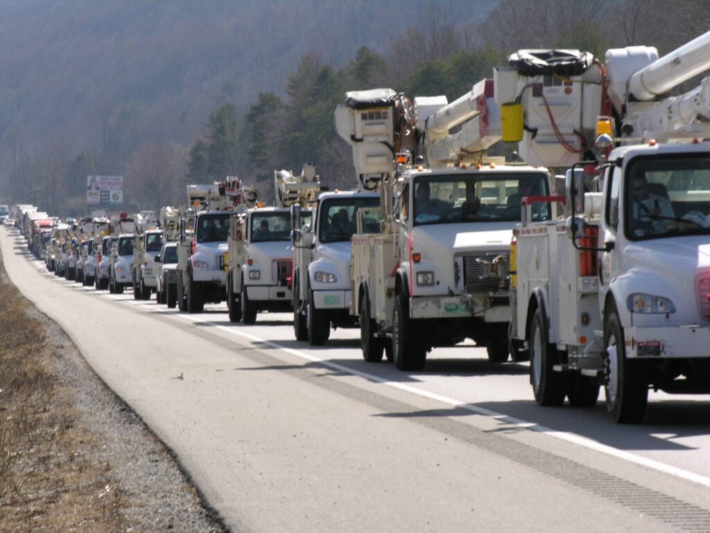 Now, when the recovery teams arrive…. If you are on the road and there’s a convoy of utility trucks on the road, pull over. Treat power trucks and tanker trucks like ambulances and emergency vehicles. Pull over, give them a clear road and let them pass.
When everyone gets to work, if you see a lineman, pole-digger or crew say thanks. Just simple “thanks”. Wave at them and give them a thumbs-up. No need to get unnecessarily familiar, a simple: “thank you for your help” will suffice. You know, ordinary people skills.
Many of these smaller crews will be sleeping in cots, or in their trucks while they are working never-ending shifts. Some will be staging at evacuation shelters, likely schools and such. The need to shelter people and recovery crews might also delay the re-opening of schools.
Once you eventually start getting power back, if you see a crew in a restaurant, same thing applies… “thanks guys”.
Same goes for the tanker truckers. The convenience stores with gas pumps are part of the priority network. Those will get power before other locales without power. Fuel outlets are a priority. Fuel is the lifeblood of recovery. Hospitals, first responders, emergency facilities, fuel outlets, then comes commercial and residential.
Remember, this is important – YOU are the first responder for your neighborhood. Don’t quit. Recovery is a process. Depending on the scale of the impact zone, the process can take days, weeks and even months.
Take care of your family first; then friends and neighborhood, and generally make a conscious decision to be a part of any needed solution.
Pray together and be strong together. Do not be bashful about being openly thankful in prayer.
It will be ok.
It might be a massive pain in the a**, but in the end, it’ll be ok.
√Andrew
√Jeanne
√Frances
√Ivan
√Charley
√Irma
√Michael
Ian
Keep a good thought. Who knows, we might even end up shaking hands.
It will be OK. Promise.
Wise, realist words.
Fort Meyers tide gage on NOAA website
observed water level in red is DECLINING as easterly wind on the north flank of the storm is driving surface seawater out to sea
that’ll reverse as southerly wind in the east flank of the storm starts piling water up on the coast (storm surge)
I’ll post updates, the tide-gage network is a good resource to monitor storms, I watched the Atlantic City gage back during Hurricane Sandy and was able to advise my family there. Water was in their yard and they were starting to freak out, but I was able to tell them “relax, that’s as far as it’ll rise, the tide gage is declining now” – meaning the eye of the storm had passed them and the wind had switched and was now blowing water back out to sea – the back bays were starting to empty out through the inlets.
I plot on local time and MSL datum (mean sea level), which is a more readily graspable zero datum than the primary reference of mean lower low water (MLLW) that’s used by the specialists in tidal data
click on the link, I’ll attach a plot in a few minutes
https://tidesandcurrents.noaa.gov/waterlevels.html?id=8725520&units=standard&bdate=20220925&edate=20220929&timezone=LST/LDT&datum=MSL&interval=6&action=
Blue line is astronomically predicted tide
Red line is observed (actual) water level
Observed is quite elevated from predicted in the runup to today, that can result from prevailing wind, thickness and temperature and density of ocean water levels, buncha meterologic and oceanographic factors
Here’s the St Petersburg tide gage in Tampa bay
I shows similar super-elevation of ocean level (red) in the runup to today and is trending down but not as much as Ft Meyers because it’s farther north and those strong easterlies have reached there yet
of main interest will be to keep monitoring as storm surge develops, to monitor how high it’s getting
https://tidesandcurrents.noaa.gov/waterlevels.html?id=8726520&units=standard&bdate=20220925&edate=20220929&timezone=LST/LDT&datum=MSL&interval=6&action=
oops, in 1st post above, thats
thickness and temperature and density of ocean water LAYERS
and in 2nd post, should be “strong easterlies HAVEN’T reached there yet”
Thanks for that cool data, Nimrodman.
It looks like that 6AM high tide will fortunately be before the storm landfall. Hopefully the landfall will be directed onshore toward Fort Myers and the surge will be greatest south of there extending toward Naples. This scenario would result in much less property damage for western Florida than if the storm veers more northerly toward Sarasota. That would result in a much worse surge and property damage for the Cape Coral/Fort Myers area.
Wow. Very impressive. Are you a meteorologist, or something like it?
Retired groundwater hydrologist, I studied island water resources.
Nearshore groundwater levels fluctuate with the tides so I had to download tide data to plot up against my well-water levels, try to subtract tides out, that sorta thing. That put me on to the NOAA NOS (National Ocean Survey) website, they operate the tide-gage network.
Water levels and rainfall would vary with climate cycles so I had to learn about and factor in timescales longer than tides, things like the seasonal cycle, ENSO (El Nino – Southern Oscillation), and decadal cycles.
The oceans are moving around all the time, at a lot of different time scales.
“Mean sea level” is an abstraction, something you can get by running an “average” through a long data set.
But the ocean is never resting there at mean level.
… oh, and I’m a surfer
you learn about weather and storms and which way the wind’s blowing if you’re a surfer
Based on the current track projections Charlotte Harbor is where to watch for maximum surge.
Punta Gorda, Charlotte Harbor, Florida Tide Station Location Guide (tide-forecast.com)
thx, rah
that’s near enough to Ft Myers – I know how to get around on the NOAA site so I’ll stick with that; NOAA doesn’t show that Punta Gorda gage on their page, it must not be one that they operate
if you can get some instructive graphs out of that forecast site, pls post here, particularly on storm surge
I looked at Natl Hurricane Center’s storm surge graphics and couldn’t quite grok them
Probably read manually.
although this table is helpful
https://www.tide-forecast.com/locations/Punta-Gorda-Charlotte-Harbor-Florida/forecasts/latest
on the ‘wind’ row, it shows wind forecast to remain easterly until a very brief period of south wind, then the wind clocks around to west then northwest
that means a very short duration of south winds from the east quadrant of the storm, that’s where surge is generated most, I think, because the wind direction coincides with the storm-advance direction (both are ‘pushing’ in the same direction and comin’ atcha)
so there may not be a whole helluva lot of storm surge built up before storm comes on shore an cuts across to the Atlantic
we’ll see
could be a lucky break
anyone have recollection of storm surge coming off the back side of the storm?
any voice of experience?
I have a bit of a personal interest. The family vacation home is on a channel off the bay at Port Charlotte. Taken the boat up the rivers there when Mom and Dad were snowbirding. But I never get to use these days because whenever we go to Florida it is to visit my Girls and youngest Granddaughter at Daytona Beach.
So sad. We used to sail around the west coast of Florida. Praying for all my friends’safety and all of those in the path.
My sisters live in manufactured homes in Punta Gorda. Everything appears to show that their homes will not exist after this.They are 3 feet above sea level and will get a 9 foot surge with 6 hours of 100+mph winds. They evacuated yesterday.
I just can’t imagine. I’ll take snow and cold over this any day.
Only structures that stand up to cat 3 and cat 4 at all are cement and rebar. Even that’s not assured if a tornado takes it up a notch from the sustained winds.
Thanks nimrodman – always enjoy your posts and I love learning how “akaw” all of the Treepers are! Stay safe. Have this quote framed in my office and it can be applied to all life challenges and not just surfing 😉👍❤️ “You can’t stop the waves, but you can learn to surf.” – John Kabat-Zinn
Now that’s more like it….you totally blew your CTH coolness factor with the geeky hydrologist stuff, but I’m good now that I know your a surfer!
Next thing you know, Dutchman will tell us he’s a banking exec or a cpa🤣
That is some great info, thank! I’m passing it along!
😂
Yes you would! The West Coast was our service area (telecom).
Husband’s family lives in Ft Myers but staying in NC. They live on a canal and secured as much as possible before they left. Pls keep us updated Nim.
Thx.
Sundance, thank you for all that you do to help people in so many different ways and in so many different contexts.
Dito that, CTH Reader.
Thank you and stay safe, Sundance.
Prayers up.
Thank you Sundance! Our first year in FL and here comes IAN! Your updates have been so helpful.
We will of course rely on local updates. We are in NE FL. But we will not escape the effects.
We will be with family, 3 little ones under age 4, keeping them calm with hugs and activities, and prayer.
The 2 oldest are learning to pray and seem to take to it very well, so there is that.
More than that, we will rely on God, help the neighbors, and be thankful when the roar stops, the sun comes out, and give thanks for not losing our life, if the best pans out that is!
Blessings to you Sundance, your team, and to all Treepers!
Little kids are the greatest distraction in the world when the SHTF!
God sure knew that!
I Give thanks literally every day for them!
Thank you sunnydaze!
May all blessings flow to you and yours.
May your faith be rewarded and all of your prayers be granted.
Awww, thank you Liz!
May God bless you!
God bless you and keep
You and your family safe
Thank you Gonzotx!
May He bless you & yours 🙂
Floridians help Floridians and others also, many have been through these windy, rainy days before. They know the value of assisting others and paying forward because over a long enough time line they know they need help. Been through these thing for almost 60 yrs now on both side of the state.
Welcome to FL, stay safe.
That’s right. My FL friends have secured both houses..My Amelia Island friend is at my house now and she wrapped my crystal cross and is taking it with her!!!
Appreciated hearing that Edink, thank you!
Prayers for you and the little ones..We have a house on Amelia Island and one in Ocala..I just talked to my friend on Amelia..she said the wind is strong on the Island..7.28am. Ocala is being used by a family from the Tampa Bay area..I’ve offered my guest house to friends near Ft Myers/Pine Island but they can’t get out.
Dear P Ward,
Thanks for your reply. Even though we have only been here just a year, we have been to Amelia Island several times already!
Beautiful area and the downtown section is fun as well 🙂
https://www.windy.com/
I’d forgotten about that site – thank you! The radar and satellite maps of the hurricane are better and more accessible than most “weather” sites.
I pray and claim Psalm 91 for those in harm’s way
Dear Heavenly Father, let these people affected by the hurricane dwell in Your secret place and abide under the shadow of the Almighty. Be their refuge and their fortress, their God in Whom they trust. Please, deliver them from the snare of the fowler and the perilous pestilence.
Father, I pray that You will cover them with Your feathers and under Your wings they will find refuge.
I pray that Your truth shall be their shield and buckler.
Your Word says that they shall not be afraid of the terror by night or the arrow that flies by day. Nor will they be afraid of the pestilence that walks in the darkness or the destruction that lays waste at noonday. A thousand may fall at their side, ten thousand at their right hand, but it will not come near their tent. Only their eyes will look and see the reward of the wicked. Lord, because they have made You their refuge and their dwelling place, no evil will befall them and no plague will come near their dwelling. For You shall give Your angels charge over them to keep them in all of their ways. In their hands the angels will uphold them so that they do not strike their foot against a stone. You will make it so that they will be able to tread and trample the lion and the serpent. Because these, Your people love You, You will deliver them. You will set them on high because they know Your Name. They will call on You and You will answer them. You will be with them in trouble and deliver them and honor them. With long life You will satisfy them and show them Your salvation.
As Your Word has promised for those who love You, so we claim this promise this day for these, Your people, in the mighty and powerful Name of Jesus Christ! Amen!
Amen
We will cling to the Lord thru this verse thou-ought the next 18 hrs.
.
Please do not cease praying for us here in SW Florida.
Whoseyore, Thank you. Our Pastor just preached a sermon on Psalm 91. He called it our Our Fight Song.
Prayers to all.
Sending prayers and hopeful thoughts.
We have a 12 acre farm in middle south Georgia. I know next to nothing about the experience of hurricanes. The one I was in was the one several years ago that I think came ashore around the Florida gulf coast bend. Of course merely tropical storm (or less) level by the time it got to us.
But the constant sustained wind (mere “breeze” when it got to us) with considerable gusts was quite unnerving. Just went on and on for hours. I ran out to the barn to look out over the pasture and woods beyond (couple medium size Pecan trees in center of pasture) and it was pretty mesmerizing the beating that tree was taking.
The constant and sustained rain squalls that seemed to never end. And of course we had no real damage. We are a high point in the immediate square mile, so no flood risk. I can not even imagine what it’s like in the real thing.
This one even looks like even less impact for our place in south Georgia. Looks like Georgia coast may get some impact of the “leftovers”. Thoughts and prayers to all of you.
Category Hurricane Michael devastated the coast from Pensacola to Panama City and inland. Homes, businesses, farms and forests were destroyed. Years later, there are folks still displaced by that storm in Thomasville, GA and Tallahassee, FL.
Category 5 that is – need more coffee.
We have a son and daughter in law in Naples – I’m up early to follow the storm and listen out for news from family and friends affected by the storm.
Now is the time to stock up on chili dogs from the Cordele Pool Room.
We can get all this elsewhere. Let’s ne covering what the Deep State is pulling off while the news media are obsessing with the storm.
Sundance is somewhat preoccupied right now. Perhaps you might consider starting your own blog. Then you can post whatever you wish.
You get a mulligan, but that’s the only one.
You obviously didn’t read THIS article, (because you won’t get insight like Sundance the CERT provides in many/any other places) and/or didn’t notice SD also took the time to post the Tucker article re: Nordstream 2 sabotage, i.e. “ covering what the Deep State is pulling off while the news media are obsessing with the storm.”
Don’t recall seeing your handle here before, but like BoBo noted, this is your ‘mulligan.’ Don’t be a jagoff here.
Hey Chad, feel free to start your own blog, that way you’ll have the control you want. 🙂
I’ve been visiting this site since Feb 2012 (when Trayvon Martin got himself shot), this site has always been a mix of current events, politics, and even personal stuff.
That is when I joined!
Sundance is the best!
I don’t want to chew up too much space talking about it but I found this place when I went hunting for info because the media narrative about Trayvon didn’t make sense. I think it was when they said he was 17 but in the famous Hollister tee pic he looked maybe 11. Cue the sound of an old record player needle scratching across a record. I found this site and there was already very active very intelligent research and conversation going on. It was amazing. The trial was the absolute best.
Always the Best Words from Sundance 😊
Thank You 🥰
~~~~~~~~~~~~~~~
Prayers Up for All 🙏
We Need You ,
Every One of You ~
Please Be Safe 💞
I’m a bit late to the prepping part of the party but I recommend 5 gallon Igloo jugs. You can fill them with either cold or hot water quickly and the will hold water warm for at least 36-48 hours. Having hot/warm water can be a big morale booster.
Reports that storm surge put Key West under water.
https://www.toddstarnes.com/weather/breaking-25-foot-waves-near-key-west-island-hit-by-massive-storm-surge/
Some Key West webcams are not online but I did find a couple that show not all of it appears to be flooded.
Sloppy Joes webcam
https://liveduvalstreet.com/
Mile Marker 0
https://fla-keys.com/webcams/mile-marker-zero/
The power seems to be on in Key West. More webcams from that city at https://fla-keys.com/webcams/key-west/
God help all those in the path of this raging storm.
In Jesus name I ask.
Amen.
My sister is in Fort Myers and she ignored evacuation orders. 🙏🙏🙏
My BIL is in Cape Coral, spoke to him last night. He doesn;t seem overly
worried, has the storm shutters up, the necessary supplies and generator,
He said he is flood Zone C and that the canals near him have locks to
prevent flooding so he is not worried about that.. We shall see when next
we talk to him.
Daughter and SIL and three babies and my wife and 2 houses on Pine Island. I’m loading the truck with every tool I own and doing a pilgrmage to FL with expert chainsaw experience and bad back if necessary. Either a clean up and patch job or trash out and demo job.
When my grandson calls me “Boppie” it lifts my spirits and I see God briefly”
Godspeed, prairiecreek. Stay safe. My prayers go with you.
God bless you and your family, Boppie.
Best wishes and the best of luck to all the treepers living along the hurrican path in Florida.
couple more tide gage plots
I left off the predicted tide and plotted actual observed ocean level (red) and the difference between that and the predicted tide (purple) … think of it as the residual of observed minus predicted, a residual trend line
at Key West, water levels are rising … Key West is receiving storm surge from the hurricane winds driving the ocean up against it
at Ft Myers and St Pete, water levels are falling steeply … Ft Myers and St Pete are experiencing a “blow-out low tide”, as strong easterly winds on the top side of the storm are blowing ocean water out to sea … it’s storm surge in reverse
if you go down to the beach there right now, the breaker line will be a lot farther out and you’ll be able to walk a lot farther out on wet sand. but ya gotta hurry, tide’s on its way back in already
you’ll see those blow-out low tides over on the Atlantic side in winter, when cold fronts come thru with strong westerly winds … same same
here’s a streamline / wind-barb plot
you can see the strong easterly / northeasterly winds on the top side of the storm that are driving that ocean water offshore in the Ft Myers – St Pete area and making for the blowout low tides there
… the contoured colored areas mask the underlying shoreline map so you can’t see exactly where things are but it gets across the general principle
Roger that, Flyover
They were showing blow-out tide this morning on Fox’s Weather Channel (which is over-the-air, pretty cool for us antenna users). It looks absolutely freaky and reminds me of that awful Indonesian tsunami when the ocean receded from the shore before the tsunami barreled in. I don’t know if they are the same phenomena though, the tsunami just being a much more exaggerated version.
yeah, I saw a reporter doing a stand and talk at St Pete and describing it “and at some point all that water’s going to come rushing back in” yada yada
If I remember correctly Kathrine Hepburn’s Sea Side Mansion is right about where Ian is projected to make landfall.
I’m remembering a hurricane movie in a big house, I think it was ‘Key Largo’ and I think Bogey was in it
i could look it up on imdb but I’m sure a couple Treepers will sound off with the details from memory
Okay I will bite…Bogey and Bacall…..
a love song from long ago, with hints and nice pix:
Bogey and Bacall…..Not the movie…but a love song from long ago, with hints and nice pix:
thanks, Aggiegirl — nice additions to the thread
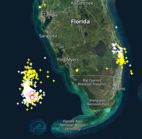
What is happening down there in the south and south east. Jupiter and the barrier islands? It looks like they miss a direct hit but that might not help too much in this storm. Can they go under water entirely? That sounds crazy I know, but you Floridians are not far above sea level.
judging from the forecast path of the storm, those areas will be crossed by the underside of the storm, its south side
winds on the underside are westerly, so as the storm affects southeast Florida, the west winds will blow the ocean out to sea, the same kind of blowout tide that St Pete and Ft Meyers were experiencing
so they’ll have the opposite of storm surge, they’ll have blowout
I reckon
Thanks!
but up in Jacksonville they’re going to catch hell, winds are already northeast and will intensify
those onshore NE winds will drive storm surge there
that’ll span from maybe Cocoa Beach on up into Georgia, time will bear out exactly where and how much
Live beside an active volcano and assume llava wil eventually fall.
Nice, blame the victim.
I don’t think it’s practical to expect people in the US to avoid every part of the country that has periodic bad weather. lol Then everyone would be crunched into a small area in the middle of … nowhere.
I live in the middle of that nowhere.
We get blizzards you wouldn’t believe.
😂
I cannot think of a single place that escapes some kind of periodic natural disaster. Maybe San Diego? But who wants to live in California (until they finally break through and install a Republican Governor again)?
Southeastern Arizona is good. We get torrential rains in summer which we enjoy after months of dry, dry, dry the rest of the year.
San Diego has earthquakes. Been through a few there.
Hmmm….why do they always rebuild with the same BS roof structures so they blow off next time?
Cost?
Dunno.
We make ours cyclone safe in Nth QLD with small steel corner fabrications and steel top plates anchored to the slab. Use bolts not nails for anything structural. Then with battoned Colourbond roof skin. Nothing moves.
Yeah, 5 thousand more.
But no more doing the same thing over and over and expecting a different outcome.
Are you sure it’s the same buildings losing their roofs?
God bless you Sundance!
God bless the people of Florida!
God bless the hard working first responders and recovery crews who will be working tirelessly during this period!
Bless you, Sundance, and stay safe!
Remember, when it is safe to drive, every single intersection must be treated like a four-way stop…. and YOU ARE GOING TO HAVE TO PAY ATTENTION. Even the major intersections.
Common courtesy. If two vehicles arrive at the intersection at the same time at right angles the one on the right has the right of way.
From Levi:
Textbook progression of an eyewall replacement cycle in aircraft data from Hurricane #Ian today.
Over the last 12 hours, we’ve seen the emergence of a secondary eyewall (pink markers) in wind traces, initially weak (top), then becoming dominant over the inner eyewall…:
Based on my own observations of eye wall replacement cycles in other hurricanes it seems that pressure stays static or increases slightly until the cycle is complete. Once the cycle is complete the core of the cyclone and eye are a bit larger in diameter.
What Joe Bastardi says about eye wall replacement.
Eyewall replacement cycle weakening going on. So now what you do is you seed it to try to stop its from coming back. I am big advocate of seeding strong storms coming to the coast
In an0ther tweet he says that when Ion makes landfall in South Carolina it will be nearly as strong as it will be when it comes ashore in Florida. It is now past time for the people up there to start paying attention.
Nullschool showing wind currents. Looking out to the east you can also see AL99 Invest. That one is currently projected to recurve out into the Atlantic well before it reaches us.
earth :: a global map of wind, weather, and ocean conditions (nullschool.net)
If you click the icon down to the left corner of the screen you can call up imagry of wind at various levels and other information such as seas state.
Satellite image of Ian and you can see this disorganization of its eye as it is going through the eye wall replacement cycle.
Weathernerds Satellite Data
I will now have more time to watch Ian.
I have finally gotten the five rows of the 3/8″ laminate floor back in place that had to be removed to get the new dishwasher under the kitchen counter. It fought me every inch of the way and the final row I had to use bar soap to lubricate the tongues and use a block and 3 lb. hammer to pound it in from the end. But it went in and the finished job meets the approval of the chief inspector, my wife, and so all is good.
Seems kinda trivial when many 1,000s are wondering if they’re still going have a kitchen doesn’t it.
Pressure dropped from about 2980 last night around 10pm to 2962 right now. Very little rain on the southeast side coming in.
We’re in the outer circular region due east of Ft Myers and wind is more like 20 mph gusts…it shows 40s.
Maximum wind in the red eye wall area on the south side is 138mph.
I am the Patriarch of a family of power linemen.
My first hurricane in my career of linework was Andrew, yes that was a long time ago. I have been on a many of hurricanes,tornadoes, ice storms and snow storms that me and my crews put in unbelievable hours of work.
I will not be on this one, but my family will be headed there to work.
As with every one of these major catastrophes I have been on, there is always at least one lineman fatally injured. These are very dangerous times for line crews. One of the most dangerous is a generator providing emergency power at someone’s residence or small business. Most people do not realize if plug in a generator to your homes distribution panel that it can backfeed onto the power line. Please be careful of this.
The best way to handle the generator potential for backfeed ia removal of the power meter. Just pull it from the socket.
You will have line crews from all across this country coming into your community, these men are on a mission. A simple thank you and smile go a long way. And if you do have the ability to offer a cup of coffee, most crews will thank you profusely.
When they arrive in your neighborhood, the best thing you can do is keep everyone back out of there way. These men are professionals at there jobs.
Sit back and watch how well all the moving parts of powerline building seem to magically come together.
Anyone that uses a “suicide cord” from a generator into a dryer or range outlet, or hardwires a connection to the panel, rather than using a GENERATOR TRANSFER PANEL, is a complete raving idiot.
However, natural selection continues to work regardless of warnings.
Suicide cord is a good name.
I do not fault anyone though for it. I realize they are just trying to provide for family.
When I arrive with crews, the first thing I do is start hunting down the generators. When I find them I pull their meters.
I have been questioned a many of times why I pulled their meters and I always take time to explain it to them. I understand the position they are in. When we get a circuit back on I usually go back around with power companies bird dog and reinstall the meters after we verify all generators are disconnected.
I forgot to tell folks about there service risers on their homes. This is were the power company connects to your home.
If your riser has been ripped off your home the crews can not reconnect it.
You will need to get an electrician to come rebuild your riser. This is to keep from burning your house down because of shorted wires that was caused by the storm. Usually trees are what damages a residence electrical riser.
Please ensure that you use a licensed contractor to do this, and watch out for scam artists trying to RIP you off. You can ask for their license number, a good contractor will not get upset if you ask for it.
There will be a lot of good people there working very hard to help you restore power to your homes.
You do not pay the line crews, they are paid by the power company you buy electric power from.
But if you need repairs made to your service point at your home, you have to pay an electrician to come to your home.
I am praying for all of you.
PS
I am on here all the time, if you see my name and have a question dealing with electrical at your home due to storms damage, I will do my best to help answer any questions.
Passed a convoy of about 20 power trucks on I-12 at 6 pm yesterday, heading East to FL. Opened my sunroof and gave them all a Tumbs Up and most waved back, some blew theire horns. A few trucks were pulling large low boys with huge cranes on board. I was headed home to Slidell, LA from NOLA.
Thank the Lord for these dedicated, brave people heading to the danger to restore power and MAGA!
Many weeks after Camille in ’69, the linemen and their power truck that resored our power on the MS Gulf Coast house were from Oragon!
Imagine the 2,000 mile trek they took to come to our rescue.
Great guys, I offered them cold, iced down beers and they refused, but took the iced cold water. (We had loads of ice at home from our family’s big Ice Plant that had a temporary Nat Guard giant generator installed, but no power at home until they rolled up through our back gate. Camille blew down a giant Pecan Tree that took out our power lines.)
Glad to report that my house has a generator switch on my distribution panel that was installed by a licensed electrician for about $ 600. I start her up, switch the panel to the generator, then plug in the heavy line to the breaker that leads to the panel. Simple and works great eveytime with no danger to anyone,… runs my entire house, including the AC.
You Linemen do great work and are very much appreciated by those in disaster areas,.. Thanks.
Great post. Those men deserve all thanks you give them. It fills me with pride when roll out for storms and you see thousands of rough talking hard working men.
When everyone goes inside when weather gets bad just remember the lineman are going to work.
Thank you for that great post once again.
PS I am from Louisiana originally, up until I left home at 17.
I’ve never seen the term “suicide cord” before, or used a generator, but I totally comprehend the problem. It reminds me of an old house I bought where the homeowners wired a 2-prong lamp cord to a 1980’s fridge and plugged it in to a 1950’s vintage 2-prong outlet.
Thank you for doing a dangerous job.
Along with oilfield workers, you are the unsung guardians of the quality of life we enjoy. Times like these help us put things in perspective.
Most of the ground lightning strikes are either in the Palm Beaches or on the western side of the eye. There is a stationary front around Tampa across the central part of the state. That’s contributing to the rain on the north feeder bands.
The low number of ground lightning strikes is good news for the power grid.
As the wind picks up along the coastline the transformers will start blowing for various reasons–Outstanding greenish arcs visible for miles. Just one of the visible memories of the ‘caines.
One of the better things that FPL did has been doing in the backgtround is to install timed/re setable circuit breakers on pole transformers, rather than fused links, on power drops that are not buried. That will probably help individual homeowners this time around.
Live Stream – Hurricane Ian strengthens to Category 3 storm, set for landfall in Florida today | LiveNOW from FOX
https://commoncts.blogspot.com/2022/09/live-stream-hurricane-ian-strengthens.html
This,may seem insignificant in the overall picture, but don’t forget about pets. Keep them safe, have enough food and maybe have an alternate place they can go to the bathroom inside if need be. Not only for their comfort, but also for hygiene reasons.
Thank you for finding the time to inform and comfort the people in the area.
Good luck to you Sundance and your recovery team……..
Thank you!
I remember the debris from a Cat 1 hurricane. 2×4 spear stuck in a telephone pole. And this is Cat 4. It will flatten structures and fling lethal debris everywhere.
Yes, a Cat 4 can even damage cinder block, concrete and rebar. Anything else will be demolished.
and don’t expect all the services you’ve come to know and love to be restored by the weekend. There will be no power, no water, no internet for at least a month.
Nothing irritates me more than people, 48 hours after a storm like this has passed, on TV bitching because they can’t watch Netflix at home.
If occasionally being inconvenienced like this upsets you, Florida is not the place for you.
Not just Florida–planet Earth isn’t the place for you.
There will be no power, water, internet, cell service for months in hardest hit areas. However, most of the state will have power restored within a week. The areas not badly destroyed.
“Imagine being in a tornado for 18 hours”
Imagine people have been warned for over a week the tornado is coming and didn’t move out of harms way. I’d venture to guess 98% of the people who stay had the ability to evacuate.
Evacuate can be as simple as driving to the east coast of Florida. Often times a hundred miles can make the difference…
But evacuating means you don’t know what happens to your property and you can’t get back to it until the authorities allow you to. I totally understand why people don’t want to evacuate so I won’t criticize them. I think it would be an agonizing decision.
Your property or your life?
Sometimes it only takes 5o miles. One hurricane, I think Floyd, kept moving N on me. I ended up in Valdosta (sp?) Georgia and turned around and drove home.
People who live around Lake Okeechobee need to be cautious and prepare for major flooding. Florida only has a few natural waterways to shed water. A few lead to Lake Okeehobee. Lake Okeechobee’s inputs/outputs:
Primary inflows
Kissimmee River, Fisheating Creek, Taylor Creek
Primary outflows
Everglades, Caloosahatchee River, St. Lucie River
If you are in or around these waterways as well as the Big Water prepare for major flooding as the storm progresses and drops a lot of water in central Florida.
This includes those in or around Orlando. The hurricane is one thing but those inland need to be prepared for the inevitable flooding.
St Johns River flows up state.
SW FL pray for them looks like it is going to be a cat 5, Central FL (me) Cat 1 like Irma. This is not going to be good.
Links and live cams near landfall site:
Ft Myers – has photos and maps – https://www.fox4now.com/weather
Live Camera Naples – https://www.fox4now.com/weather/weather-cams/bayfront-inn-camera-wftx-weather-naples-live-conditions
Other landfall weather cams – https://www.fox4now.com/weather/weather-cams
Another good site –
My Fox Hurricane –https://www.myfoxhurricane.com
Data from hurricane hunter indicates Ian is nearing CAT 5 intensity. Winds now 155 mph. This is an extremely dangerous hurricane.
Pressure 930 and dropping…..
From the historian and statistician of hurricanes, Phil Klotzbach:
Having never been through a hurricane this was all very interesting information to me. The 2 things I’ve not experienced – a hurricane or earthquake (of any significance). Wish I could have given this to my sister (she’s in Bradenton) and is currently hunkered down. I was surprised they didn’t get out.
I rode out Camille, years ago, with two very small children and a husband out plugging holes in the levee south of New Orleans. And yes, you think it will never end. I had not seen so much rain in my whole life and have not since. But the day after was glorious, all sunshine and silence. A soggy wet mess out there but we were all OK, just like Sundance said, we were OK. I will never forget that sound or that rain.
Too bad we can’t drop Biden right square in the middle of this soon to be mess……let him experience this with the best of the deplorable domestic terrorist. Let him see just how important electricity and gas are. Let him see what it is like to go a week without it then he will realize what a gift it is.
He be lost during and clueless afterwards.
He’s vaxxed so the hurricane isn’t as bad as it would’ve been.
Guy on the ground in Punta Gorda
Here in Venice FL hunkering down with family and pets from who have left Evacuation Zones A and B. Already rockin’ and rollin’ outside. Hatches battened down but it don’t look good. Our Indian Princess is supposed to be keeping us safe, but she seems to be busy elsewhere. Trying to stay positive!
High tide in Port Charlotte is at 6:04 pm today.
Even near current low tide at Cape Coral, I notice the lock cams there on the inland waterway have a higher water level then last night when the tide was coming in. Won’t take much to flood that today. The hilarious part was, at about midnight last night, watching a local there fishing in the rain and wind near the locks.
Here’s the camera looking what I believe is westward, toward the Gulf… currently still operating.
Incredible live action footage of the storm as it builds. I pray God keeps everyone safe.
All my family is there, and they are all staying, may God be with them
Uplifting words! Thank you!
God bless and comfort everyone going through the storm and those who love them.
God bless and give strength to all those who are staged to help the people of Florida. In Jesus name. Amen.
… and God bless all as well
Please excuse my poor etiquette inserting at top of thread (for greater visibility), but I know people are eager for information on storm surge
Day-of-storm tide-gage plots
Shown are predicted tide in blue and actual observed water level in red
Naples is experiencing storm surge to about 7.5 feet above mean sea level
Fort Myers has storm surge to about 3 feet above mean sea level and rising steeply
St Pete is still in a blowout tide condition to about 4 feet below mean sea level, Fox talking head was just showing it on TV and warning people not to go out there shelling because the water will return at some point
Note:
Fort Myers just added another foot of surge in the last 45 minutes since I made that plot
it’s now up to 4 feet MSL
Thanks for updating. Relaying your report to my people in area
Ft Myers now +6.3 feet above MSL (Mean Sea Level) at 4:30 pm local time
Naples stopped transmitting at 1:06 pm local time at +7.4 feet MSL
St Pete still declining (blowout) at -4.5 feet below MSL at 4:30 pm local time
Ft Myers was +7 feet above MSL (Mean Sea Level) at 5:18 pm local time and may have peaked, the next subsequent reading was down slightly
Naples stopped transmitting at 1:06 pm local time at +7.4 feet MSL
St Pete stopped transmitting at 4:36 pm at -4.6 feet below MSL (blowout continuing)
I suspect we won’t see the 18 feet of storm surge that’s been mentioned
Ft Meyers peaked at about 7 feet above mean sea level and has now dropped to 4 feet
That’ll be it for storm surge there, now that the storm center has come ashore and wind direction will be swinging around
oops, disregard prior plot, that must have been a squirrelly couple of readings
Ft Meyers is still up at 7.8 feet above MSL at 6:06 pm