All residents in the Northeast coastal region, specifically Long Island and Southern New England, should pay close attention to local officials regarding precautions as Hurricane Henri begins tracking in that direction. The forward speed is 21 mph and the wind speed around the storm is 75 mph, a category-1 hurricane.
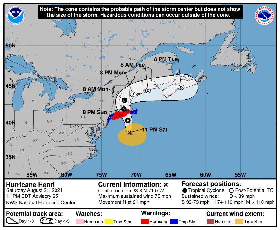
[National Hurricane Center] – At 1100 PM EDT (0300 UTC), the center of Hurricane Henri was located near latitude 38.6 North, longitude 71.0 West. Henri is moving toward the north near 21 mph (33 km/h) and this motion is expected to continue through tonight. A decrease in forward speed and a
turn toward the north-northwest is expected on Sunday. On the forecast track, Henri is expected to make landfall in southern New England or on Long Island on Sunday. After landfall, a turn to the north and a slower forward speed are expected as Henri moves over southern New England. (LINK)
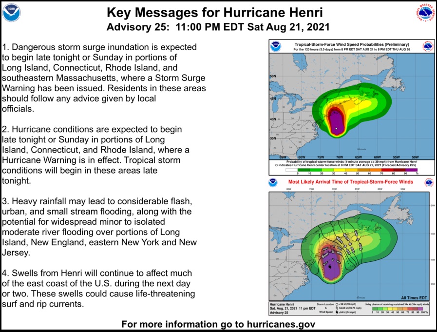
WIND: Hurricane conditions are expected in the hurricane warning area on Sunday, with tropical storm conditions expected by late tonight. Tropical storm conditions are expected in the tropical storm warning area late tonight and Sunday.
RAINFALL: Henri is expected to produce rainfall amounts of 3 to 6 inches over portions of Long Island, New England, southeast New York, and New Jersey Sunday into Monday, with isolated maximum totals near 10 inches. Heavy rainfall from Henri may result in considerable flash, urban, and small stream flooding, along with the potential for widespread minor to isolated moderate river flooding.
Sudden Sea is an excellent book on the 1938 hurricane. Sand from Narragansett was found in Quebec. There was zero warning it was coming.
The “Long Island Express” hit Long Island as a Category 3 hurricane in 1938. I was born and raised on Long Island and everyone my parents age remembered it as if it were yesterday. https://en.wikipedia.org/wiki/1938_New_England_hurricane
Left Oceanside in 1968…fond memories…
I left Rockville Center in 1971. Still have 2 brothers and 1 sister on Long Island. Southampton, Northport and Long Beach. I miss Jones Beach and surfing on Gilgo. It’s going to be great surf this week! I love Long Island, but I love the Texas Hill Country more.
I left Long Island for good in January ’77. I’m from Northport!
So glad I sold my house on Long Island in February. Here I am in Florida and the hurricane is hitting NY.
Better Governor!
Weird, right?
I’m watching from Florida, too, hoping all my family/friends up that way will be fine.
Most of ’em should be, as long as they prepared.
Hope it blows the UN building into the Hudson.
The Red Pill: East River would do.
billrla, your comment gave me good laugh.
“Unfortunately, many are today confused about the concept of nations because there are a group of state representatives in New York calling themselves the United Nations. Of course, most of them have no legitimacy at all. They are mostly gangsters with flags. The United Nations is today the largest collection of unelected dictators, mass-murderers, drug-traffickers and human-traffickers on the planet… ”
—Rev. Dr. Peter Hammond
Most of the turmoil this country and the world sees today is directly because of the U.N.
With agenda 21 or 2030 as its now called signed by all 193 countries in 1993 it is enough for that building to be evacuated and every member be escorted directly to the nearest airport and have their passports confiscated and be evicted from this country for life.
Their silence over the last year + is telling as to their part in the attempted destruction of this country and the world
Now THAT would be awesome!
Laugh till I fall off the couch
And Gracie Mansion too!
Direct to Martha’s vineyard? Wrath of God is raining down on them.
I hope so…
Maybe the “tides will rise” on the 44th’s castle…
Let it rain, let it pour
till there is no more.
Let it take Barry and Mike!
Apropos … getting hit on Sunday, a true, seasonal blue moon.
And all blue states to boot … perhaps they will find God, especially when they hear the sound of the storm, even if it is “just” a Cat 1 storm.
Think of the recent history of Hurricanes and Presidents, and the imposter in there, now.
His peoples whole m.o. seems to be “Whatever TRUMP did, do the opposite!”
This does not bode well, for residents in the path of this Hurricane,…the administration will tell FEMA to “stand down” while they CHANGE the policy on naming Hurri,…THEMacanes, to non binary, gender nuetral names, and then blame Trump and Climate change for the royal clusterf*ck of a responce,..I bet they have already gotten rid of all the top people ‘from the previous administration’ at FEMA,…
GOD is weighing in,…indeed.
Prayers for those in the path,…
Spoiler alert: they won’t. Just double down on their global warming BS, cuz dey’s neva had hurcanes up disa way!
It’s another welcome cover for corruption and grift.
It’s been following the western side of the NHC’s projection cone all week, but the latest track has it trending quite a bit east of the projection earlier today. Looks like the track has moved from central Long Island directly to Block Island and then to mainland Rhode Island.
Edit: https://classic.nullschool.net/#current/wind/surface/level/orthographic=-68.86,38.06,3000/loc=-70.545,38.545
hurricane gloria redux.?
that was a doozy – eye passed directly overhead, took 20 minutes!
tree damage was incredible.
no power, no water for 2&1/2 weeks.
folks there are resilient,
but emergency services are not what they are in the ‘hurricane belt’.
We are hardy New Englanders.. If prepared..and we certainly had more then enough time to do so.
We will be fine..if the power goes out I guess my entertainment will be listening to the news and
how the latest storm agmegeddon is upon us..AGAIN..
But Gloria was a Cat 3 ..And as of the last update Henri has now been downgraded to a Tropical Storm
So far in Central CT just some rain and a little breezy when you go outside but not really seeing the trees swaying yet.
yes, a BIG cat 3!
was new to new england when it hit – had never been in a hurricane before, being from the tornado belt.
after the initial 8 HOURS of hurricane winds, pretty much clear never wanted to do that again!
you speak of hardy new englanders, and you are so right.
absolutely remarkable how tough they are.
even among the incredible, apocalyptic devastation, they were out and about doing what they had to do.
never complaining, just doing.
i liked the people so much i stayed for years!
glad to hear henri has been downgraded. hope the flooding is minimal,
and those trees don’t sway too much!
take care!
Sucks for them
No it sucks for me
It might suck for me too.
Me too
Prayers for you and your loved ones.
Thank you Sarah!
Sending prayers for you and your loved ones.
So sorry. Prayers for you and your loved ones.
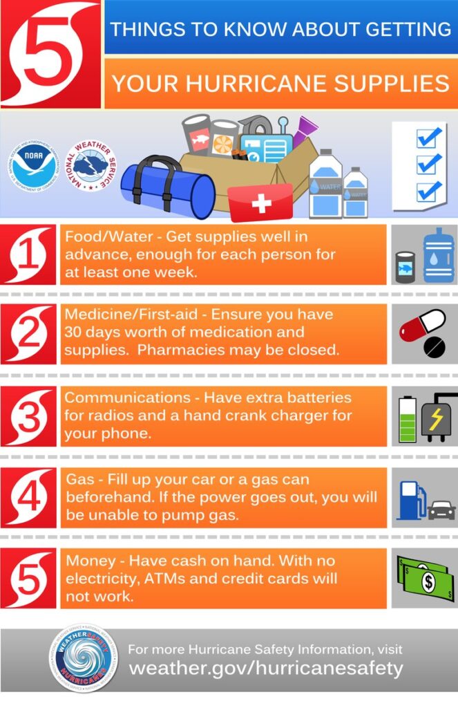
the 4 things everyone should have at a minimum.
speaking from experience with two major canes backs to back last year:
1. water…lots of it.
2. gasoline…lots of it
3. ready to eat meals…lots of it
4. a rehearsed plan with immediate neighbors in your block so that recovery, surviving, and coordinating help can happen.
other things that are useful:
batteries for everything including backup cell batteries or those rechargeable devices.
buckets of regular water for washing clothes
medicines and first aid kits
chainsaws and rubber boots
bolt cutters
crow bars/bully bars
a trusty tractor that can haul drag and or front load
a written down list of contact numbers
rain water catching methods
tissue paper and disenfectabt wipes
rope or wire for hanging clothes to dry
blue tarps for temp shelter and drying in leaks
a weapon and some ammo
food for the dogs
Manual can opener
Pop-top cans (in case your hand is injured).
—
and razor knives.
C-rats can opener. Put it on your key chain.
Can’t believe there are people who don’t have manual can openers.
Just discovered recently that some don’t!
A block of dry ice for the freezer.
Gas for the grill.
Generator
Now that’s getting into “luxury” for many – or even impossible in places like Manhattan..
But , battery fans are available now, which is better than nothing.
We had a storm here in MI and were without power for three days. Hubby finally relented and bought a Generator. It saved the refrig and freezer.
Buckets / containers of water to flush toilets.
Plastic Milk Cartons lined up behind the toilet works.
You can leave ’em there……forever. Old Earthquake trick.
Years ago we cut down all trees within 30 feet of our house and every time we have high winds I am so glad. Never fall in love with a tree. Generators are great. Luckily, I grew up with power outages and septic issues. In those days you could light your gas stove and oven with matches. Buckets were our friends. Living in the country does have its advantages during times like this.
Preferably some cover for the buckets and water to minimize mosquito breeding
Its a Category 1 . Its not Andrew, Camille, Katrina or Mike coming to visit.
I understand that…I also understand that a non hurricane like the one that happened in Louisiana three years years show that flooded baton rouge for 6 days and the one non hurricane that hit Houston two years ago that flooded for 16 days…are no joke.
the thing about being prepared..getting the items in advance…?
it gets you in the right mindset for lots of different scenarios..many of which few have every experienced, fewer can predict, but ARE a very real risk.
In Houston, Harvey was a Tropical Storm that hit once and left and then rotated back. Houston got 50+ inches of water. Many homes were flooded again after just rebuilding from hurricane that hit two years earlier. Thank God, President Trump was in office. The people in the Gulf coast are use to hurricanes, but it helps to have good government to assist. Love thy neighbor, really comes into play, big time after these storms.
One of my young’uns along with her mate and three of their young’uns are right smack dab in the bullseye very near the CT coast and were unable, due to multiple reasons, to leave the area. I’m praying for their safety. Any additional prayers offered are surely appreciated.
Youngest lives further inland but that’s not saying a lot in CT. Prayers for your family too!
Thank you Jb!
Prayer offered.
Thank you!
Anytime friend.
Prayers for your entire family GB…..
Thank you sincerely, Ad_rem!
Prayers for your family…
Thank you Sarah!
Prayers for them! God help them all!
I thank you, BossLady.
Sending prayers up. ?
Thanks, Lizzie!
How about a direct hit as a Cat 5 on DC? That is what is warranted.
Last time I checked, those you could envision impacting live somewhere else and would likely be able to evacuate and be fine.
Prayers up for our East Coast friends.
Stay safe. Keep us posted, if able.
Central CT here..Latest update as of 11:pm (waiting for the 5:00 one) pushes it a bit more eastward more towards RI.
Went to local hardware store at opening already a long line gas containers going off the shelves people buying up or
trying to order generators.. My neighbor drove to NY to get one.. We bought one after last years storm where we were without power for 4 days..Even our local small town IGA store was quite crowded for early Sat Morning..
Now we are suppose to get more rain than heavy winds. We could get heavy rain about 6 to 10 inches
Our electric company Eversource yesterday predicted (before the slight change in track will see if they update) but they
decided to kinda scare people (hence the run on generators) by saying they expect 50 to 60 percent of thier customers to be without power and could be 5 days to a week or more before it is restored.. I think they want to seem like they are prepared after the mess they had last summer with the storm where some were without power for 10 days or more and they had very angry customers..
I don;t get why people wait till the last min.. it is not like no one expected we get plenty of warning.. there were runs on gas stations some running out.. People filling up multiple gas cans..long lines at the pumps.. To hear the media
armegeddon is coming.. and will again likely this winter with whatever winter storm comes out way as if major winter storms don;t happen often in CT..you would think that the case listening to the scare mongering of the news for any of these event.
Not that it is not something to take seriously but we are talking a Cat 1 storm here.. Gloria was a 3 or 2 when it hit in 85 and we all survived..This is New England folks,we get storms and sometime big winter storms they are not novelties. We are suppose to be hardy New Englanders but to hear the news we are dainty little things that panic at the first snowflake
or drop of rain from any big storm..
AS I tell my kids we don;t Cat 4 or 5 up here as the water is too cold to support that.. and we are inland so we won;t be swept away by the storm surge and people lived without power for millions of years..just BE PREPARED..
So far it looks like Boston is in for a good soaking and some hefty breezes, at least I hope that’s all what with two mature trees that are probably closer to the house than they should be.
Stay safe xx
So those two trees I mentioned? Well I’m happy to say that the one that went didn’t hit the house…
https://www.facebook.com/messenger_media/?thread_id=2321157251256239&attachment_id=1499411057075373&message_id=mid.%24gAAg_FIltz6-Bn7sLeV7bnWTk6fDw
Not our car. I don’t see any broken glass.
Fire Dept. got here in just a few minutes.
It took out their windshield.
Nice to meet ya Jenevive! I’m just down the road in Central CT also….My husband and I took a ride to the Indian Reservation yesterday thru Colchester around mid-day, and the lines at all the gas stops!!! On the way home, around 9-ish….the convoys of power co. trucks was impressive to the south eastern part of the state. We are well water and septic, so we lose it all without power….the generator is ready and the gas cans filled. The only unfortunate thing for us, our property is surrounded by those hundred-year-old+ trees…oaks and maples. Nothing close to the house, thankfully…..but the mess is horrendous when the storms rolls out! God bless – stay safe!!
My neighbor drove to NY to get one. Even our local small town IGA store was quite crowded for early Sat Morning..
Sounds like Kent area, home to Sam Waterston. Kent’s closer to NY than Bantam, which also has IGA. Biden/Harris signs outnumbered Trump signs in Sharon last year when I was in CT (former NW corner resident) by 10 to 1 last year. Those ignorant dummies have no idea about Obama’s Affirmatively Furthering Fair Housing Act that gives federal ‘oversight’ to local zoning and mandates X% of town land be put aside for high density public housing. AND it requires town residents be taxed to pay building costs of those projects.
And still my prayers go out to you and yours! May our merciful Lord protect our Patriots, and scare the others into becoming faithful ones!
Here is a live streaming webcam on Coopers Beach in Southampton. It’s 6:14 a.m. and the surf is already wild.
As with most things that happen on the eastern seaboard, especially the northern half, this probably won’t even be a very big deal, but they’ll flail their arms and scream because that portion of the country is the center of the universe. Just like whenever NYC gets any amount of snow it’s a national news story. Give me a break. ?
https://nypost.com/2021/08/22/tropical-storm-henri-brings-storm-surge-flood-warnings-to-northeast/
That’s wild surf?
Thanks Kitty. My brother and family live there on Channel Pond Ct. They will be hitting the beach with surfboards when it’s safe. Sure miss my Long Island. Stay safe. God bless.
I normally have to worry about my elderly Mom in FL during hurricanes there. Currently, I’m at her home in FL dealing with a broken pipe and resulting water damage. Mom’s staying at my house in CT. So now I have the reverse…worrying about her there instead of here. God surely has a strange sense of humor.
I’m in the northwest part of CT (higher elevation) so I’m not worried about flooding. Just concerned about excessive rain and wind which can topple trees.
Have an emergency generator and plenty of propane to feed it, plenty of food and supplies. And sister-in-law is staying with Mom and her little dog. So Mom should be fine. It’s just so strange my being in FL while hurricane hitting CT! It’s upside down world.
Prayers for my fellow Nutmeggers and others in the path of Henri. May we all come out unscathed and keep our loved ones, 2 and 4-legged, safe. ?
LI’er here, morning update looks improved, as the storm track is already slid out east of Montauk.
Our biggest concern is always storm surge. High tide this morning along most of the south shore is 8-9:00, and it’s a full moon tide. Thankfully, most of the island is already well west of the eye, so the (counterclockwise) backing wind will be northerly in direction. That stiff northerly wind will actually impede some of the tidal/storm surge from flooding the low lying bay areas…we’ll take all that help we can get on a full moon high tide!
Still, more concerned about ELECTION FRAUD, than this rain shower with a fancy French name…
Godspeed, Patriots!
Wish it would just head for Manhattan island and wipe it off the face of the earth.
From lower CT, appears Henri heading further east toward border of CT & RI.
Prayers to all in its path.
I wonder how many billions of our tax dollars will be heading to New York’s new governor because of this?
Disaster relief will probably be in her first speech.
As an ocean side resident in SC I grow weary of the hysteria over a little wind and rain. It’s a FACT that these storms are hyped and people with no real sense of purpose love to get all worked up over them so they can feel relevant.
It’s well established here that anything rated Cat 3 or lower is a rain storm.
Reject the hype. These are government generated ratings after all…….
We get the same hysteria here with snow.. Winter Storm whoever.. anything up to a
foot or over is like snow armeggdeon.. Whatever will we do…OMG.. Hello snow plows,
snowblowers. shovels..plenty of them
and plenty of abled bodied people to use them..It the same every year when a big storm
come you would think it is first one any of us ever experienced.
I was in high school when the “blizzard of ’66” hammered MD a few miles north of DC. It was – perhaps – the first experience “triggering” a lifelong inclination toward critical thought. Long after the immediate effects had been dealt with by those with a functioning brain cell or two, “blizzard porn” remained ongoing radio fare. We thought it head-shakingly funny. Sadly, no swamp creatures were harmed in the making of that blizzard…
Where I live we call every snowstorm “snowmageddon” or “the white death”.
Yawn. From SWFL.
But be prepared for 08L and other more deadly things.
Weather happens be prepared. no quantitative wind speed gust or sustained no cat rating, satellite looks disorganized.
Steinbeck also wrote about 1960 Hurricane Dorina, in book Travels with Charley.
Before Leaving Long Island.
75 mph winds & 3-6 inches of rain ???
When that happens in the middle of the country, and it does happen with some frequency, it is never national news.
My husband was a lifeguard down on the Jersey shore in 1979 when the remnants of Hurricane David hit there. He lived near the beach with his brother and they decided to go check things out before the storm hit. The winds were high and they decided to walk down the beach “moon jumping” named for the distance the wind blew them when they jumped. So, they were having fun but left the sand and got back on the boardwalk to get home.
As they walked along, they realized the entire beach where they had been minutes before was filled with water and waves. Youth feels immortal. They made it through obviously, but probably only slightly wiser.
Here in middle of LI, light rain, no wind.
Family near Boston reports heavy rain
Friends living on Long Island tell me this morning they’ve had the usual wind and rain that always comes with these kinds of storms — nothing different or worse from what they’ve seen before. Yard cleanup will begin once the wind and the rain slow down.
Agree.
I’m on the eastern fringes of the watches/warnings and conditions so far have not amounted to more than a mild Northeaster. Storm surge is probably a bit higher but not anything intense.
I will believe it when I see it. If New Yorkers and Rhode Islanders do a little boarding up, this little storm will just pass through and do some raining. A storm moving at 21 mph is not building up, it is finishing up. But, since this storm is heading for New York, it becomes everyone’s problem. Maybe people shouldn’t build houses so close to the water. Water levels will probably rise about 4 feet until the eye of the storm has made landfall, if it ever does.
For New Yorkers. Don’t bother with the slanderous responses to this because I don’t control your weather and only you can control your responses to the weather.
Im in CT. Just outside of Hartford. It is 110pm and the non stop coverage of this storm doesn’t match the reality outside my window.
It was worse during a storm last week. My co-worker closer to the shore bear RI. Said it’s rainy and thats about it- doesn’t match the frantic weather people on tv.
Even the live video they showed….was not in alignment with the talking.
I’m in the Storrs/Mansfield area (communist state of Connecticut), lost power around 12:30 pm. On generator now. I have 2 days worth of gas to run it. Other than that and a few large limbs in the yard due to occasional 50 mph gusts, things are ok
Hope our biggest problem will be getting our 2 dogs to venture out to do their business. Right now they want nothing to do with that
conserve the gasoline as much as possible..
roughing it for most hours is not convenient, but wise.
remember during power outages OR NOT, there bud always a run in gas.
it depends mostly on the efficiency and priories not the supply chain which no one has any control.
even a small disruption can cause long delays getting back to just half capacity..
so conserve.
Trying to
im 30 minutes south.
All is good here. And, all around that area…I hope you are not the sole person impacted.
Seriously. I hope you’re not lying to get sympathy.
The storm was nothing. Im 10 minutes from Hartford. Predicted to get worse than you in Storrs (you’re an hour and a half from shore- mountains…..)
I hope you’re not the sole person to be so impacted.
I resent being called a liar. My power was restored last night at 9:00 pm. 54 neighbors were affected.
You got lucky
Please tell me this hits Martha’s Vineyard & wipes out Ovomit’s mansion. OK.
I wish no one any harm. Natural disasters happen, but it will be blamed on climate change no matter what. So sick of this….
Henri is Mother Nature.
Coronavirus is not.
And which has been more harmful?
What’s been done about it?
Well here in Central CT at around 4 p, we have Rain…that it rain…not even any real wind
maybe a breeze once in a while.. but otherwise I have seen worse pop up thunderstorms…
well at least tomorrow I will be busy putting back all the Patio furniture and outdoor decorations
that I spent yesterday putting away…
This just in: The Obama compound on Martha’s Vinyard has been totally destroyed. God said he had had enough.
Have you HEARD how the newscasters are saying the name of this storm? “On-ree”…. oh, are we French now? It should be pronounced “hen-ree”…. we are in America and English is our native language. Tired of everyone trying to take away our Pledge of Allegiance, our guns, our sporting events, and next will be our apple pie. We are AMERICANS. Start acting like it!