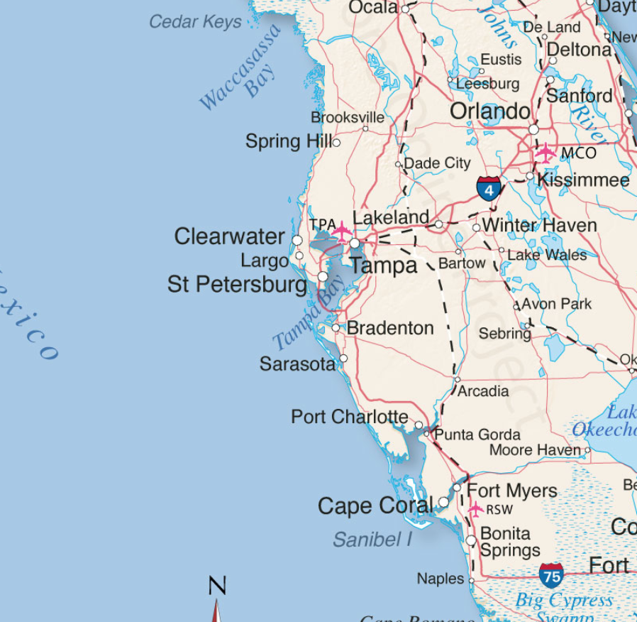
The projected path of Hurricane Ian, a category 4 storm, has now been narrowed. Landfall is anticipated just North of Cape Coral in the Punta Gorda, Port Charlotte area. Lee and Charlotte counties will likely feel greatest impact from Ian starting overnight through all day Wednesday, with eyewall entering Southwest Florida (SWFL) overnight Wednesday.
All preparations must be rushed to completion. Power outages will likely start sporadically happening early to midday tomorrow (Wed). Evacuation zones have been expanded due to increased storm surge prediction. Pay close attention to your local officials and local media. If you are staying in the Lee or Charlotte coastal area, now is the time to finish inside preparations. Local SWFL radar is now tracking storm [Local Media Link].

Boca Grande Pass, famous for exceptional Tarpon fishing, looks to be the immediate coastal area where the greatest wind driven storm surge will impact. Gulf water will be pushed up the Caloosahatchee and Peace rivers creating expanded flooding further inland. The flooding and storm are anticipated to be the largest in SWFL history and are the greatest risk.
(NHC) – Maximum sustained winds remain near 120 mph (195 km/h) with higher gusts. Ian is a category 3 hurricane on the Saffir-Simpson Hurricane Wind Scale. Re-strengthening is expected later today through Wednesday. Ian is forecast to approach the west coast of Florida as an extremely dangerous major hurricane. Hurricane-force winds extend outward up to 40 miles (65 km) from the center. (more)
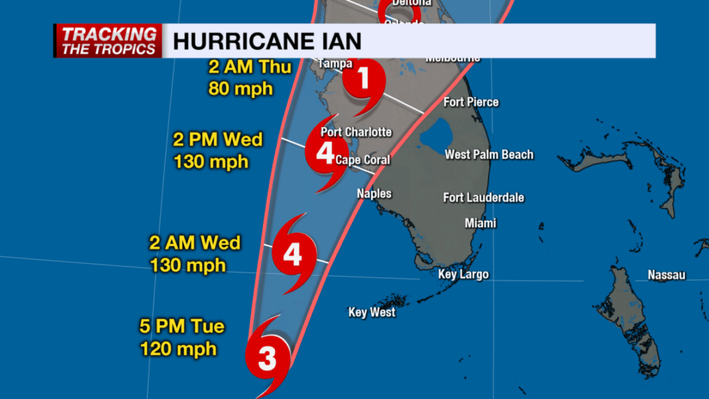
(NBC2 News) – Because of the location and movement of this hurricane, Lee and Charlotte and coastal Collier Counties are under hurricane warnings. It is important to stress: DO NOT FOCUS ON THE CENTER OF THE FORECAST CONE. IMPACTS FROM THIS HURRICANE WILL EXTEND FAR BEYOND WHERE THE CENTER OF THE STORM IS.
As of 5 p.m. Tuesday, the forecast cone has shifted east of where it was earlier today, meaning the potential of a Category 4 hurricane landfall is higher in Southwest Florida than it was 24 hours ago. (more)
Stage your battery powered lights and weather radios.
Turn down your refrigerator to its lowest setting anticipating power outage.
Freeze bottles of water to fill empty space in freezer.
Secure all important papers in waterproof bags and stage in central location.
Take a refreshing hot shower.
Fill cleaned and sanitized garbage cans with water in shower and/or bathtub.
Bring in outdoor furniture or throw it in the pool.
Put all your most critical items in an interior room without windows.
Put your most critical needed emergency items in easy reference place.
Elevate anything you might fear getting damaged from flooding.
Fully charge your portable electronics including cell phone.
Eat a good meal
Get rest tonight. Do not allow yourself to be overcome with dark imaginings.
Flood Zone Map for State of Florida, “Know Your Zone”:
https://floridadisaster.maps.arcgis.com/apps/webappviewer/index.html?id=c788060028cb43809a25744ead39c0d6
Thank you! I think my ‘hood will be okay, for now. That said…and Mother Nature can be a tricky wench…so time will tell…
Am very worried and prayerful for the people in harms way…
My hood is on the Peace River…..
Such a beautiful River!
One article I just read said it is very good for finding fossils.
If you get the chance, go check out the Natural History museum at University of Florida in Gainesville. They have great displays on the fossil history of FL. Most of FL was reefs in ancient times, which led to a plethora of shells and unique creatures.
I have fossils from the Adirondacks in NY.
I had a couple of friends who would go over by Arcadia somewhere when the water would be very low during the winter (dry season), park their chairs and start digging.
I love camping on that river!!
BE safe!!!
I just looked it up…it looks very quiet and peaceful in the state park…reminds me of a creek we used to swim in…
This was interesting…
https://www4.swfwmd.state.fl.us/peaceriver/natural.php
Ron DeSantis is Evacuating Illegals to Martha’s Vineyard ahead of the Hurricane.
Ok. I am from California but don’t you have to worry about alligators in the waterways in Florida? I know they show up in swimming pools occasionally?
And SNAKES
Same concern snakes, crawling cockroaches and alligators bigly! How do scream out of tht nightmare i wd be terrified
Assume a gator is in every body of water, including ditches. The only freshwater I would swim in Florida are the freshwater springs. There was a fatal attack in Blue Springs a few years ago. They are tragic, but rare.
I would not be swimming in that creek!
Thanks!
que será, será
Stay safe……
Praying for all in the path.
I have family in FL but they are on Atlantic side and should not be as greatly impacted.
Tornadoes are forming all along the southeastern FL coast tonight.
I’m in Cincinnasty getting ready to head back to Arcadia with tools and such. I’m expecting my motor home to be gone but one can hope. It is (was?) tied down with some serious ground tackle so I can hope.
It’s in a motor home park just off the Peace River but if it survives the wind it won’t float away. 🙂
My biggest fear is FJB will not do anything to help or will mess up any response.
YW, Aggie.
Even parts of NE FL. are recommending evac. if they’re in Zone A, because of tides and rivers.
St. Johns County just added Zone B. So now Zones A and B.
I found this online:
http://www.tidetablechart.com/tides/region/Florida%20:%20East%20Coast
High tide is going to be somewhere between 11pm and midnight, give or take…without influence of storms.
Everyone has blown this storm way out of proportion 3 days ago.
Many who we never hear from have said for 3+ days there is to much cold air coming from up north for this hurricane to be as devastating as many are claiming.
Projected wind speeds from 30 to 50 mph with gusts up to 74 mph can be seen on many weather sites and this hurricane and the model show it destroying itself once it hits land and will barley make it half way thru the state before it’s demise.
From your keyboard to God’s ear!
That is an evacuation zone map, not a flood map.
Wind Map:
https://www.ventusky.com/?p=27.1;-76.2;5&l=wind-10m
Thanks for that map. It explains why our daily afternoon breeze from the ocean hasn’t occurred and we’re still really warm. I live in San Diego north county a few miles inland.
Interesting map, right?
And it’s so easy to see the wind speed!
Try this one…
https://earth.nullschool.net/#current/wind/surface/level/orthographic=-75.92,40.32,917/loc=-81.970,30.182
Another cool one. Thanks!
I use Waze app on my phone. It does all this and more. I use it frequently for real time precipitation as it is normally only a few minuet’s delay. It also does wind, waves, snow, and many other useful things.
The storm is coming.
Yes, Null’s good, too.
I use that site for severe thunderstorm watches.
That is an excellent weather radar map. Thanks!
That just warms and intrigues my little nerd heart.
Most beautiful sunset we’ve had in a while here in NE Florida.
Bright pink sky and bright pink bottoms on every cloud!
Now the whole thing is turning orange!
And back to pink again.
But it is a beautiful thing…
“Red sky at night, sailors sleep tight”.. 🤣🤣👍
🇺🇸💪😀👍
Some of my family just left miami and moved to St Augustine- eek.
A lot of south FL. people are moving up to N. FL.
Lots of complaints from locals about that, cuz of the RE Market and traffic, mainly.
But I think most understand that the long-time S. Floridians are trying to escape the influx of Northerners during Covid.
So it’s just a big vicious circle.
S.Florida types like amenities. I am 15 miles from a Big Box store off several miles of dirt road.
That is an excellent move, other than being in the path of Ian. Miami is a bit much, these days. And I used to have quite a bit of fun there in the late 90’s.
Looks like we got lucky on on this one..neighbor 🙏👍
🇺🇸💪😀👍
Maybe.
Just heard this Gina Loudin (Lewdin?) on RAV say the same thing from Palm Beach. “Bright pink sky.”
Interesting!
It’s not unusual for pre-storm skies to have intense, unusual colors. When a particularly strong storm hits (whether it’s a typhoon, cyclone, or hurricane), the skies can take pinkish or violet hues. While it may look beautifully ominous, there is a scientific reason why this happens — and it involves physics. (courtesy google…)
Found this…pretty….
Interesting article…tid bits about tides pre hurricane…https://sciencestruck.com/warning-signs-of-approaching-hurricane
It was quite beautiful tonight.
It was so orange the whole sky had a glow. Beautiful.
.
The weather in front of a hurricane frequently gets beautiful right before the edges hit… And then…
.
Prayers from flyover country for anyone in Ian’s path.
Donation to Samaritan’s Purse for disaster assistance made.
Samaritans Purse is great!
Also Hope Force International https://www.hopeforce.org/
They take a little longer to arrive but they go to the missed areas. The small places where the need is great but often not as noticed.
+1.
Hope and pray that our blog host has relocated to safe ground out of the path and away from the surge zone.
I have family in the Orlando area. How bad will it be that far inland?
People from Tampa are evacuating to Orlando- seems that it’s a good spot to be right now.
Friends from Sarasota are at a hotel somewhere in mid Florida.
Yep, happens no matter which coast the storms come in from. Eleventy million inland hotel rooms is a good place to be.
No one knows what it will do until it does it.
It’ll be messy, tons of rain 20+ inches. Wind gusts 80 sustained winds 60 to 70. Just below a Cat 1 but that can change. Taking a very similar course to 2004 Charlie which hit as a Cat 1. But this one has a lot more rain. Not good for a zero lot line with poor grading and a pool a 7 feet from the back door.
Once upon a time I had to fix a whole bunch of grading in Baldwin Park. And Lake Nona.
start draining down your pool.
Check the city website for the city that they live in. There should be lots of info, more specific to the area, I would think.
My link went to moderation…go to http://www.ocfl.net/storm
Its a link to Orange County.
Bad. Florida is a stick in the wind.
Err…water.
Sister says she is going to weather out the storm in her Winter Garden home. This is her second home. There for her grandson’s first birthday.
She’ll be good. Center may be real close to her as she’s 20ish min west of Orlando. Storm should lose steam by then. Charley eye went over us. We’re 20 min N of Orlando. Still here.
Not expected to be horrible. In ‘94, Charley started us off on back to back to back hurricanes with a tropical storm kicker which brought more rain than the hurricanes. We’re expecting it to be Charley-esque, Big tropical to small Cat 1ish by the time it gets here. Of course it can change, but right now that’s what it looks like.
The pros are not worried, yet cautious and prepared. A lot of the newbies are losing their minds. Panic buying will set in tomorrow and they just start grabbing random, useless crap off the shelves. It’s pretty funny to just wander through Lowe’s and HD and look in people’s carts. Get a buddy, grab lawn chairs and beer, then post up near loading zones and run some play by play with color commentary and you will laugh until it hurts!!
I used to live in Maryland and the panic buying for snowstorms was legendary. Best line was the guy who said ‘Bread, milk, eggs and toilet paper. So we’re all having French toast and then hitting the bathroom? Good to know!”
https://www.orlando.gov/Storm-Tracking-Ian
https://www.orangecountyfl.net/EmergencySafety/EmergencyInformation.aspx#.YzOT_cvMK00
26 September, 2022
Orange County Government Public Information Officer
Email: [email protected]
Share
AddThis Sharing Buttons
Share to Facebook
Share to Twitter
Share to LinkedIn
Share to Email
Hurricane Ian Updates
Latest news is displayed first.
For resources and information on Hurricane Ian, visit http://www.ocfl.net/storm. To watch any past news conference, visit the OrangeTV YouTube playlist or the OrangeTV Vimeo playlist.
1
Update: News Conference | September 27, 2022 | 5:30 p.m.
Watch the conference on the YouTube Video Stream or on Vimeo.
Key Takeaways: Hurricane Ian Update – 9/27/2022
WEATHER UPDATE
Orange County is now in a Hurricane warning, meaning hurricane conditions are expected within the next 36 hours. Rain is expected to be the primary threat, with approximately 12-18 inches. Peak winds are expected on Wednesday afternoon, as high as 74-80 mph.
Aggie….this got held up because the all the links (8).
Orlando is under a hurricane warning.
Should be similar to Charley in 2004 if IAN stays on projected path.
Chances of fallen trees and lost shingles with possible tornadoes and lose of electrical power for weeks.
Along with heavy rains and street flooding for a day or two.
Other than that not bad.
On the bight side no storm surge and wind speed will be less than half of those where it’s forecast to initially hit land near Cape Coral.
If they are not in a mobile home they should be fine and they may only experience high wind/heavy rains with no structural damage at all.
Waiting for power to be restored and the clean-up after the storm will likely be the hardest part.
As of right now, Fort Meyers, Cape Coral, and Port Charlotte are going to flood. Tampa is not.
https://cera.coastalrisk.live/
Does this mean the evacuated residents of Tampa can return?
Whoopsie?
Tampa has managed to dodge the hurricane bullet for years.
No doubt the media is breaking out their Hurricane Katrina template. While I have no doubt Governor DeSantis and the Florida Emergency Management officials are organized and prepared (after all, it isn’t like this is their first rodeo), no matter how well they do, we all KNOW who will be blamed for all manner of misery.
Anyone wanna bet “racism” is one of the reasons the Enemedia will claim?
That reminds me, remember the map that PDJT had in the Oval Office to show people the possible track for the hurricane that was moving in? The FBI took that map when they raided Mar-A-Lago!
“ The FBI took that map when they raided Mar-A-Lago!”
Bessie … would you have a link or source to share on this?
If you follow geoengineering watch. Org.
You understand that the government can control the weather and does so quite frequently.
Is it a coincidence that Florida’s governor who used illegal invaders for a political stunt that publicly embarrassed and inconvenienced the rich and powerful libtard cartel elite.
And NOW, Florida is the target of the “most powerful storm this season”That the media will gladly use to hourly bludgeon the same said governor?
I love sure thing bets!
Lumber is running $429.30 per 1000 board feet. For a frame of reference, that is about the peek pre 2007.
Based upon the devastation I am hearing this will bring that price may surge we may be back over $600.
That will further wreck the housing market nationwide.
Sorry if that comes across as not caring about the people of Florida. I do and I am praying for their safety.
https://tradingeconomics.com/commodity/lumber
It is just a fact that rebuilding costs are going to be high. Insurers have been raising rates this year, canceling policies, or just leaving the Florida market altogether.
Eat a HOT good meal.
….it may be the last hot meal for several days.
FYI…don’t know why, but my little town on the Atlantic side (gee I haven’t said since I was a Zonian),
is advising residents there to have a TWO WEEK supply of water for cooking/drinking…( there’s a reason Rush used to pick on it all the time?).
I am soaking up all the AC I can.
People in hurricane prone areas need either gas stoves or a gas grill. No need for cold food if you have gas.
A hot shower tho…that’s priceless
May God bless everyone in Florida! Our prayers are with all of you. I personally know people who have evacuated. May SD, family and all of you all stay safe.
^^^AMEN!^^^
https://federalinquirer.com/heres-why-hurricane-ian-is-deliberately-being-aimed-at-tampa-bay/
I always have my tin foil hat on…
Climate change? That whole megalopolis is just a foot of two above sea level. Kinda silly.
We lived in the Tampa Bay area which is especially dangerous specifically around, worse yet one over the Bay in Pinellas, Hillsborough, Manatee counties west of/inside the Sunshine Skyway. We lived two hurricanes and a tropical storm living in Pinellas, but were first over land before they got to us. I’m not counting Andrew in 1992 as all we got was clouds and like 15-20 mph winds for barely a full day. Hopefully this pig stays mostly west into the Gulf. My sister and family live there still, but they’re in Vermont through Sunday. Our people in west Florida need prayers and good thoughts right now.
The issue is the slow-moving element. In any area taking in water, if two tidal cycles clash, that will be like pipes or a toilet back flowing.
I anticipate the Cajun Navy or the like might be out soon enough.
Regrettably, I live too far away to give any direct nonmonetary support. You all are in my thoughts though, and I wish the best for all.
May God bless you all and shelter you from the worst of the storm.
I got the johnboat ready. The Cracker Corps always takes care of their neighbors.
Ian is having a problem as the outer bands run into the SW parts of the peninsula. The eye just broke up a bit, there was a wobble eastward with the entire eye wall, then the eye wall contracted and reconsolidated, which moved the forward track eastward. It could come in at N. Ft. Myers if this keeps happening. So, keep an eye on the lower cone in your preps.
Also, the temperature is relatively cool coming from the outer bands and that is good. Rain is a light drizzle. Normally, it’s really hot and humid and the rain comes in hard sheets. This is my first one where it is actually cool coming in (73 right now). Heat is what fuels the beast.
Interesting. I think you can actually see that on the GOES loop: https://www.star.nesdis.noaa.gov/GOES/sector_band.php?sat=G16§or=gm&band=GEOCOLOR&length=96&dim=1
Find the actual radar loop. It’s already falling apart.
Hoping for the best to everyone in FL.
There you have hurricanes, here we have typhoons. Typhoon Noru just unleashed on the Philipines, headed north to Vietnam where major damage from floods/ wind are expected, then it takes almost a 90 degree turn left, ( never seen that before in my life ), and is now headed for Thailand in a perfectly straight line as a Tropical Storm.
Normally I wouldn’t care too much, except our house is directly in it’s path according to the map. I just checked the flood canal out back and it’s already way up, don’t know if it’s from all the rain we’ve been getting in the last month or if the govt. is releasing water from the resevoirs.
Either way it doesn’t look good.
It’s been raining almost non-stop every day for over a month now, parts of the country are already flooded from heavy rain, now they tell us to prepare for “heavy downpours”, which means it’s going to be big, since normal rain is already heavy rain.
https://www.bangkokpost.com/thailand/general/2401695/northeast-braces-for-noru
To those Treepers and others in FL, please be safe and take care …
Wishing the best to you and your neighbors Gabriel, for safety from the storms and floods
You stay safe, too. Good luck and Godspeed.
God bless you Gabriel, thank you for the well wishes. You take care, too.
You too Gabriel!
Praying for all of those in Ian’s path, for safety, perseverance, hope, joy, peace and restoration. All of the above is sage advice. This too shall pass, keep faith!
Just got 2 tornado warnings for collier county , one at 830, the second one at 9pm. Golden gate estates. Pray and help others.
Double check your map.
Good luck, Sundance. You, and others in the path of this hurricane, are in our prayers.
Pull your biggest cooler into the kitchen and when you lose power, grab the things you use most frequently out of the frig and stick them in the cooler with ice, preferably in chunks you’ve frozen overnight. These items are water, soda, milk, juice, and anything easy to eat – cold cuts, cheese, hard boiled eggs, salsa, fruit, veggies, condiments and anything else that doesn’t require cooking. This will lessen the opening and closing of the frig. Put more chunks of ice in the frig and then keep the frig and freezer closed. If the power outage doesn’t last too long, you might save your food doing this.
Hard boil the eggs and stage the things you want to pull out tonight so it’s a quick grab tomorrow. Make a many chunks of ice as you can. Plastic containers are great for this.
Good luck. We are praying for you.
Hard boiled eggs, excellent suggestion!
Great advice, Mari!
Glad I live in Montana @ 3,000 feet above sea level. My house in Florida years ago had its windows smashed and siding torn off. Don’t miss that aspect of Florida at all.
Ryan Hall, Y’All live you tube link watching the Hurricane Ian with feeds from various storm chasers:
Thanks Bessie!
Those young storm chasers are my favorites to watch!
I also tune into Weather Nation for my Weather updates and they frequently have different storm chasers on!
LIVE: Hurricane Ian latest Florida updates as Tampa and Sarasota fear direct hit | LiveNOW from FOX
https://commoncts.blogspot.com/2022/09/live-hurricane-ian-latest-florida.html
My neighbors moved back to Sanibel Island this year. My prayers for them and all in Florida continue as they journey through this storm.
I live in Naples, rain is heavy and winds picking up. My wife is driving me crazy with worry. It seems every 30 minutes we get tornado warnings on our phones. I finally made her a pitcher of Cosmo’s and she’s calmed down.
Cosmos! My sisters would want to be your friend.
My wife did the same earlier this afternoon. Took ma an hour to drive her out to golden gate estates( lots of traffic and rain) . Just the dog and I now. Must be Naples wives syndrome. Pray and do gods will.
I hope you and Marc and all of the other treepers in Florida keep your power and internet, or at least your phone service.
Sanibel on the dirty side. Storm keeps getting stronger. Watching the forecast and tornado warnings is making me ill. House full of evacuees and we’re getting the remnants this weekend. Worrying for family who stayed.
So many prayers to the people in danger tonight.
Thank you Sundance for all the work you’ve done and will do.
Excellent post. Many thanks and lots of love.
Why all the hurricane news, don’t worry about it DeSantis has this, this is his job, let’s get back on point , DeSantis isn’t Ray Nagin , what’s up with nord stream ?
There’s discussion of Nord Stream in the presidential thread. This thread is about the hurricane. Also understand that the author of this blog is in Florida, possibly in the hurricane path.
If I’m not mistaken, our dear Sundance is assisting with storm preparations as a volunteer member of one of Florida’s Community Emergency Response Teams (CERT).
The rest of the World kinda fades out for many of us for a few days.
I live in east manatee country Bradenton. My biggest concern now is the twenty inches of rain we can get on top of already saturated ground from a very wet September.
Stay safe, and please check in with us after you’ve weathered the storm (and dried out a bit).
After Katrina and Rita I hung my husband’s work uniform and needed items from the small tree. Get the radio and batteries out. Days and or weeks without power you will appreciate having the radio.
My BIL is in Cape Coral but he doesn;t seem to be overly concerned
he put up the storm shutters but said he is not in the flood zone and
the canals have locks to prevent flooding. He thinks they will get a little
water but he isn;t evacuating nor did it sound like they were
told to…will check in with him tomorrow..
Did you know that under the guise of “emergencies” evil individuals exact revenge against ex-lovers, ex-spouse, ex-business partners, etc?
It’s a thing.
If you know someone who had to take out a restraining order, or has left a bad relationship, give them a heads up to be extra alert.
We good-hearted people can’t even conceive of such a mindset.
I only know because Mr. Z trains people in Urban Survival – see the History Channel’s “After Armageddon.”
Also:
“Natural disasters, armed conflicts, economic collapse, and other emergencies also have an “aftershock” effect that isn’t as obvious at the start of the emergency as food, water, or shelter. These disasters can dramatically increase the risk of gender-based violence (GBV) and violence against children. Not addressing this violence can cause long-term damage both to the victims and to a community’s recovery efforts.”
https://www.worldvisionadvocacy.org/2020/06/24/why-does-disaster-increase-the-risk-of-violence-against-women-and-girls/
Same with Californian earthquakes. It could happen at ANY second; no warning.
Sundance I pray for you as I (think) you are in Florida. May God keep you & family safe & prepared for this hurricane. And please all Treepers here please pray for all people in the path of Ian that they will be ok.
.
A clean dry dishwasher is a good place to stash stuff last minute. Waterproof.
.
Washing machine and dryer might work too, right?
.
Side loading washing machine, maybe, although I’m not sure the seal on a dryer is equivalent.
.
You could put ice in the washing machine. Store things from the refrigerator.
Live from Sloppy Joe’s in Key West!
https://sloppyjoes.com/cam-bar/
Blessings to you Florida Treepers! My prayers will be yours.
30 years ago in 1992, Andrew hit S.Florida before heading to Louisiana.
2 things we saw.
1) Gov. Lawton Chiles delayed for three days after the strike either declaring a state of Emergency, or asking for Federal assistance.
George H.W. Bush would call numerous times offering assistance but Chiles would reject it saying he was still assessing the situation.
Then when Chiles did allow the feds to come in, the media, led by CBS/Dan Rather, led with stories about Bush’s delay sending assistance. If course it was an election year.
I don’t often give thanks for Fox News, but the MSM can’t do that now because of Fox.
2) I heard DeSantis tonight say they had pretty good building codes for wind in Florida.
That is true and because of Andrew they are enforced.
After Andrew there were several neighborhoods where a single house or two, would be standing nearly undamaged, while the rest were swept off their foundation.
So it was obvious which builders followed the Code and who cut corners.
A bunch of builders lost many shirts.
You should see houses hold up better if they are only hit by wind.
Andrew killed about 65 with Lawton Chiles help.
It is still listed as one of the worst ever.
Interested viewers should be able to see live streaming reports from Reed Timmer who is chasing the storm. He streamed about 8 hours today. Easy to find on YouTube.
I’m watching the Cape Coral Chiquita Locks video cameras mainly because that’s the area of projected landfall and it’s easy to watch water levels flowing through the locks if/when any storm surge hits. Also easy to find on Youtube, operated by City of Cape Coral.
From the looks of the streams from Key West tonight the storm wasn’t too bad. The Key West Harbor cam is still up and the power is still on for the lighting there. Palms are blowing pretty good and it’s raining. Google the name for the link if desired.
Best wishes for a safe resolution for Floridians. We have enough challenges. God be with you.
I live treeped much of the aftermath of Cat 5 Michael from here in Port St Joe in 2018. Best advice is to slow down post-storm. Shortages of housing and labor/materials inflation can seem insurmountable. Do not hire just anybody. Expect 2-3 years to get repairs completed. Best regards, OpenMind.
The only thing flyover country gets long warnings for are blizzards. 🙂
Bless all of the animals (pets, zoo creatures, and wildlife) along with all of the people.
This is who I watch. https://www.youtube.com/watch?v=tLI3Utfh0Yg.
He is a Christian who reads scripture at the end of his reports. He is live streaming for the rest of the night. Very caring individual.
I’m thousands of miles away and just north of your Pacific Northwest but I’m concerned for the people of Florida including the Floridian Treepers of course and sundance.
Canada’s Blue Jay MLB team just finished their last regular season series with the Tampa Bay Rays. Both teams should make the playoffs. I like the Rays’ players and strongly hope they will finish the season and compete in the World Series.
I hope they and all the other people and families of Florida will be alive and well during and after this Hurricane passes. U.S. Coast Guard cutters and helicopters have rescued more than a few Canadians over the years in the occasional rough waters of the Pacific NW including in Canadian waters because they had the vessels and the aircraft to save lives.
Thanks for those rescues. May the Storm Pass through the great state of Florida with only minimal damage at the worst.
I was with you until you wished the Rays good luck in the World Series. 🤣🤣🤣
I like my brotha Mark, Weatherman Plus – He’s livestreaming the Hurricane’s approach.
I just posted a link to him, too–I didn’t see your post. Love Mark–he is wonderful.
The more, the merrier !
Got word today From our favorite condo manager and great friend that Anastasia Island which is just south of Saint Augustine, has mandatory evacuation. Heads up to all on the east side of Florida in that direction! Prayers for all!
Ugh! Charlotte Cty here…
Just when teenagers thought they’d gone back to a normal life, all hell breaks loose.
My heart hurts for them.
Just had tornado, Jonathan Dickinson state park , that’s the back yard. Rain is picking up a bit going to be a wet night.
The night storms are the pits.
Getting thunder/ lightning now, feeder band gusts. Looks like it will end shortly, the land isn’t letting the eye feed.
Heartwarming to see Gov. Abbot activating large engineering and search and rescue teams to head to Florida.
Also all those electricians ready to head out.
Dangerous work, so God Bless Them.