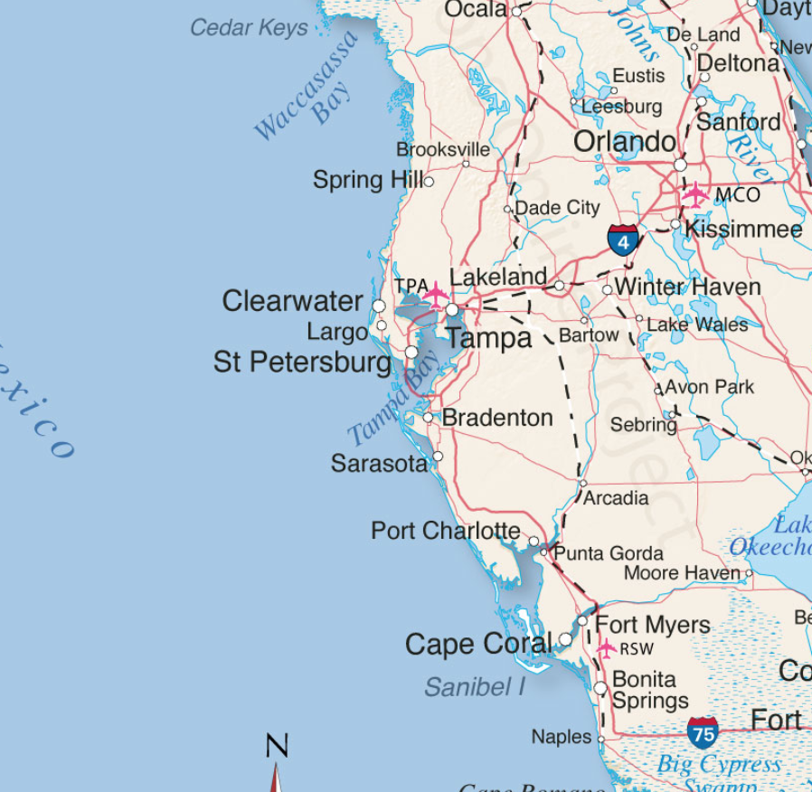
The projected path of Hurricane Ian, a category 4 storm, has now been narrowed. Landfall is anticipated just North of Cape Coral in the Punta Gorda, Port Charlotte area. Lee and Charlotte counties will likely feel greatest impact from Ian starting overnight through all day Wednesday, with eyewall entering Southwest Florida (SWFL) overnight Wednesday.
All preparations must be rushed to completion. Power outages will likely start sporadically happening early to midday tomorrow (Wed). Evacuation zones have been expanded due to increased storm surge prediction. Pay close attention to your local officials and local media. If you are staying in the Lee or Charlotte coastal area, now is the time to finish inside preparations. Local SWFL radar is now tracking storm [Local Media Link].

Boca Grande Pass, famous for exceptional Tarpon fishing, looks to be the immediate coastal area where the greatest wind driven storm surge will impact. Gulf water will be pushed up the Caloosahatchee and Peace rivers creating expanded flooding further inland. The flooding and storm are anticipated to be the largest in SWFL history and are the greatest risk.
(NHC) – Maximum sustained winds remain near 120 mph (195 km/h) with higher gusts. Ian is a category 3 hurricane on the Saffir-Simpson Hurricane Wind Scale. Re-strengthening is expected later today through Wednesday. Ian is forecast to approach the west coast of Florida as an extremely dangerous major hurricane. Hurricane-force winds extend outward up to 40 miles (65 km) from the center. (more)
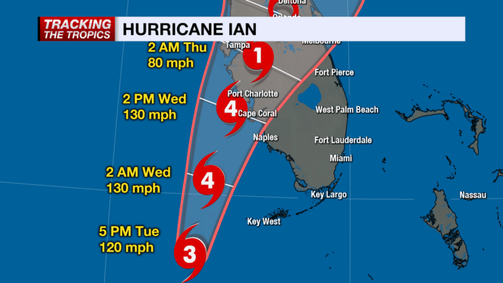
(NBC2 News) – Because of the location and movement of this hurricane, Lee and Charlotte and coastal Collier Counties are under hurricane warnings. It is important to stress: DO NOT FOCUS ON THE CENTER OF THE FORECAST CONE. IMPACTS FROM THIS HURRICANE WILL EXTEND FAR BEYOND WHERE THE CENTER OF THE STORM IS.
As of 5 p.m. Tuesday, the forecast cone has shifted east of where it was earlier today, meaning the potential of a Category 4 hurricane landfall is higher in Southwest Florida than it was 24 hours ago. (more)
Stage your battery powered lights and weather radios.
Turn down your refrigerator to its lowest setting anticipating power outage.
Freeze bottles of water to fill empty space in freezer.
Secure all important papers in waterproof bags and stage in central location.
Take a refreshing hot shower.
Fill cleaned and sanitized garbage cans with water in shower and/or bathtub.
Bring in outdoor furniture or throw it in the pool.
Put all your most critical items in an interior room without windows.
Put your most critical needed emergency items in easy reference place.
Elevate anything you might fear getting damaged from flooding.
Fully charge your portable electronics including cell phone.
Eat a good meal
Get rest tonight. Do not allow yourself to be overcome with dark imaginings.
Praying for all the good people of Florida – in addition, obviously, to sundance and all the CTH Treepers – for everyone who relocated to that free red state from lockdown blue states since the Xiden Troubles began.
From what I understand, that’s a lot of free-thinking America-First types.
If I had been one of them (wish I had but it is not to be), Florida’s hurricanes would be an entirely new and scary experience. So I hope they find treepers everywhere to help and advise them – or better, find CTH itself….
Your neighbors in Venice are Praying for you and your family Sundance.
well said, Sup
also, as to this:
Bring in outdoor furniture or throw it in the pool
that’s really clever, I’d have never thought of the 2nd part as a general rule
just fish it out later
From Venice, too, Praying for Sundance and all in the path of the Storm,
Just tuned in to the latest DeSantis presser about Ian. He said that all tolls in Orlando and Tampa have been suspended. Also has asked hotels to relax their pet restrictions and make announcements that they have done so.
This is great! Thanks so much.
FWIW, I found a site last night when I booked in the event I need to evacuate called bringfido.com. It specializes in pet friendly hotels. They have an app, too!
You’re welcome!
I think all tolls in the state should be suspended so people are not adding to the cost of evacuation. People are seeking safe haven all around the state.
They should but as of now are not. Check FDOT for the list of toll suspensions.
They have been upgrading the turnpike past couple years, eliminating toll booths/ takers, most are just pass through now.
Really keeps the traffic moving.
And the potato in DC said to make sure you have your 19 jab.
He has called some mayors but won’t call the gov, what a petty A**h*le.
Just got another tornado warning, just to the north.
My son is on the top 3rd floor of an apartment building in Fort Myers. By the time it looked like the cone shifted down to him from Tampa, it was too late to risk already bumper-to-bumper travel.
He’s a major zombie apocalypse prepper at least, so he has all he needs.
I’m worried about the roof blowing and taking him with it.
Don’t care if its weird if your mom tells you to make a rope out of your duct tape and tie yourself to the toilet, cause that’s exactly what I said.
Prayers appreciated.
You’re his mom. Of course you said that. Praying for his and everyone else’s safety.
Praying here in Cape.
You’ve got my back with prayer.
yeah, that’ll last
The one with the car and the trampoline is a Florida cracker….the cardboard ijits are yankees 🤣🤣🤣 , definitely not Florida crackers!!!!