Hurricane Isaias continues nearly on the predicted track while the intensity forecast remains a challenge. No substantive changes to the overall thinking. Outdoor preparations and home-hardening in advance of the hurricane should be completed by early tomorrow. Inland residents should prepare for power outages due to excessively high wind gusts.
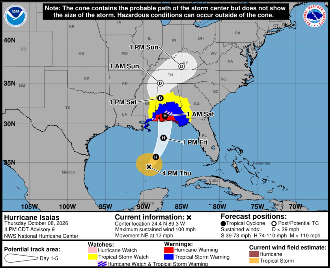
[National Hurricane Center] – At 400 PM CDT (2100 UTC), the eye of Hurricane Isaias was located near latitude 24.4 North, longitude 89.3 West. Isaias is moving toward the northeast near 12 mph (19 km/h). A turn toward the north is expected on Friday. On the forecast track, Isaias is expected to pass to the north of the Yucatan Peninsula through this evening and make landfall along the U.S. northern Gulf Coast within the warning area late Friday or early Saturday.
Maximum sustained winds have increased to near 100 mph (155 km/h) with higher gusts. Additional strengthening is expected through early Friday, and Isaias should remain a dangerous hurricane as it approaches the northern Gulf Coast Friday night.
Hurricane-force winds extend outward up to 15 miles (30 km) from the center and tropical-storm-force winds extend outward up to 125 miles (205 km). The estimated minimum central pressure is 975 mb (28.80 inches). (more)
A hurricane watch is in effect from Bay St. Louis, Mississippi, to Indian Pass, Florida. A storm surge watch is in effect from the mouth of the Mississippi River in Louisiana to Yankeetown, Florida. {Nat Hurricane Center} Those in the forecast areas are strongly advised to pay close attention to local officials and heed all evacuation orders.
Prepare for the worst and hope for the best. Everything is replaceable, except you and your family. We have a lot of Treepers in the path of this storm. If you need assistance, use the comments section of any ‘Isaias Update thread’ to reach out, or use the email address in the upper right of the site.
Right now, you are in control. Have a solid plan, work that plan – stay busy, and don’t get caught up in the hysteria. Try to avoid national media hype. Stay updated via your local news stations. Friday morning looks like the key day impact zones will be identified. Reach out to your neighbors; touch-base and check to see if they are okay or need anything. Community restoration begins before the storm arrives. Look out for each-other.
Remember the inland lessons in Tennessee and Western North Carolina from Hurricane Helene. Regarding any evacuation plan, please pay attention to your local officials who will be coordinating with state Dept. of Transportation. As the path and impact zone of the storm becomes more predictable your local officials will alert to best route(s) for evacuation.
For those in the cone of uncertainty; remember, planning and proactive measures taken now can significantly reduce stress in the days ahead. Plan when to make the best decision on any evacuation (if needed) consider Friday morning the decision timeframe. As a general rule: take cover from wind – but evacuate away from water.
DAY ONE (Wednesday) √
- Determine Your Risk
- Make a Written Plan
- Develop and Evacuation Plan
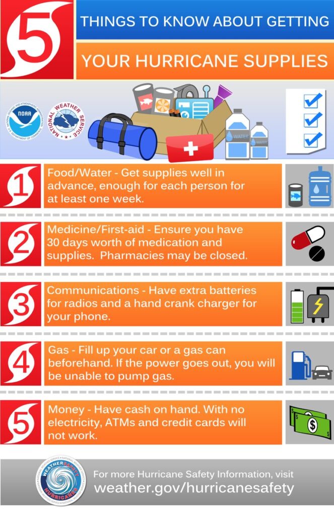
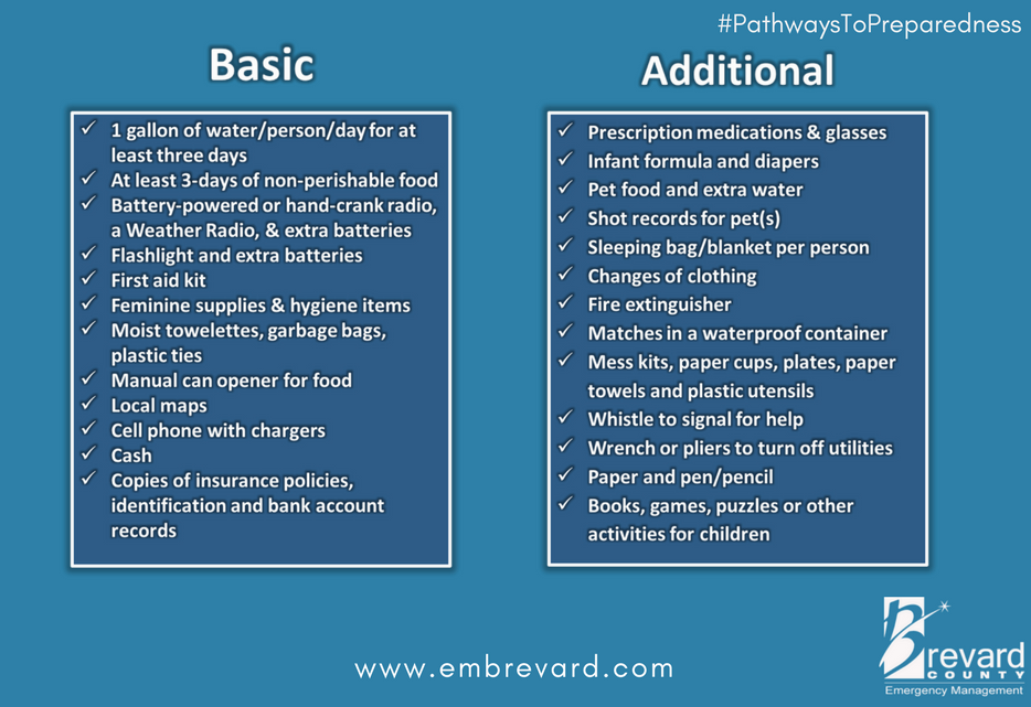
- Inventory hurricane/storm supplies.
- Withdraw cash based on plan/need.
- Get gas and storm supplies
DAY TWO (Thursday) TODAY:
- Get Storm Update
- Assemble and Purchase Hurricane Supplies
- Contact Insurance Company – Updates
- Secure Important Papers.
- Update/upload your phone data.
- Strengthen and Secure Your Home
- Discuss Evacuation Decision with your Family.
- Fill freezer with 3/4 full water jugs.
DAY THREE (Friday) TOMORROW
- Get Storm Update
- Re-Evaluate your Supplies based on storm update
- Finish last minute preparation
- Plan for a minimum of THREE DAYS without power
- Assist Your Neighbors
- If Needed – Evacuate Your Family
.
Communication is important. Update your friends and family contact list. Stay in touch with family and friends, let them know your plans. Select a single point of contact for communication from you that all others can then contact for updates if needed.
Today is the last day to organize your important papers, insurance forms, personal papers and place them in one ‘ready-to-go’ location.
Evaluate your personal hurricane and storm supplies; update and replace anything you might have used. Assess, modify and/or update any possible evacuation plans based on your location, and/or any changes to your family status. Fill car with gasoline. Review prescriptions, refill if needed.
Check your shutters and window coverings; test your generator; re-organize and familiarize yourself with all of your supplies and hardware. Check batteries in portable tools; locate tools you might need; walk your property to consider what you may need to do based on the storm’s path. All decisions are yours. You are in control.
Consider travel plans based on roads and traffic density. Being proactive now helps to keep any future stress level low. You are in control. If you have pets, additional plans may be needed.
One possible proactive measure is to make a hotel reservation further inland that you would consider evacuating to. Follow updates of the storms’ progress; make reservations tonight or tomorrow if determined; you can always cancel if not needed. It is better to have a secondary evacuation place established in advance. Being proactive reduces stress. Even if you wait until much later to cancel, it is better to pay a cancellation fee (usually one night charge) than to not have a plan on where to go. Trust me, it’s worth it. Protect your family. Make the booking decision in the next 36 hrs.
♦ Look over the National Hurricane Center resources for planning assistance.
♦ Also a great resource – CREATE A PLAN
CTH Recommendations for solid Prep ARE HERE
The Y’All Squad is Livestreaming Now:
Eyes Right…
That Ryan Yall is a hard worker.
He is JC, and contributions through their
non-profit I believe they destribute with
good and honest intentions.
I worked in environmental when Katrina came thru. Here is the sad reality of liability concerns, insurance write offs, etc. So, many lowes and Walmart type stores with total insurance write offs. So, the insurance companies “own” all the inventory. Consider the things those stores have that could be used. Grills, tents, sleeping bags, anything usable. All tents, sleeping bags, grills, etc were rendered unusable with knives, etc and because of the liabilty concerns. Sad.
Are you saying the money appeared to be more important than the lives?
Yep. It’s sad, but I don’t blame them. Lawyers would be licking their chops with a cut on metal or something. You don’t think lawyers (or “victim”) would take the slightest thing and balloon it to millions?
There should be some good samaritan law for stuff like that. Do good, don’t get liability.
BLESSINGS of Wisdom, Discernment, & Safety for each of YOU who are preparing. May The LORD protect YOU!
One in the Gulf and two in the pacific about to go in northern Mexico and southern Mexico
Have the Democrats & the MSM found a way to blame Trump for this yet? If not, just wait. They will. I have confidence in their TDS.
On a serious note, because this IS serious, praying for those along the coast. At least I’m well inland even though very close to the projected path. Gassed up car today as who knows how this may affect refineries. Surely will shut down Gulf drilling platforms. Hope everyone makes it through safely. Even liberals.
Thank you, we have family in Pensacola area and appreciate the updates
✝️🙏❤️
I got something called a “WaterBob” from amazon. It is a food grade bladder made to put in your bathtub, holds 100gal potable water, and has a hand pump. Clones are available cheaper, might be handy if you are in the impact zone.