Hurricane Helene is following the forecast track. SW Florida is feeling the impact of the first storm surge. Tropical storm force winds are being felt throughout Florida. All interests in the Big Bend area should heed local officials’ warnings and instructions. Focus on the local emergency management advice.
For those who are in the path of the storm, there comes a time when all options are removed, and you enter the “Hunkering Down” phase. You’re just about there now. Hurricane force winds extend 60 miles from center.
At 100 PM CDT (1800 UTC), the center of Hurricane Helene was located near latitude 26.4 North, longitude 85.0 West. Helene is moving toward the north-northeast near 16 mph (26 km/h). A significant increase in forward speed is expected during the next 24 hours. On the forecast track, Helene will make landfall in the Florida Big Bend region this evening. After landfall, Helene is expected to turn northwestward and slow down over the Tennessee Valley on Friday and Saturday.
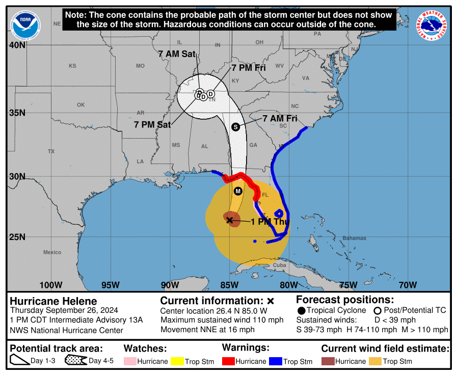
Maximum sustained winds have increased to near 110 mph (175 km/h) with higher gusts. Additional strengthening is forecast, and Helene is expected to be a major hurricane when it reaches the Florida Big Bend coast this evening. Weakening is expected after landfall, but Helene’s fast forward speed will allow strong, damaging winds, especially in gusts, to penetrate well inland across the southeastern United States, including over the higher terrain of the southern Appalachians.
Helene is a very large hurricane. Hurricane-force winds extend outward up to 60 miles (95 km) from the center and tropical-storm-force winds extend outward up to 345 miles (555 km). (link)

As many long-time readers will know, we do have a little bit more than average experience dealing with the aftermath of hurricanes. I ain’t no expert in the before part; you need to heed the local, very local, professionals who will guide you through any preparation, and neighborhood specific guidelines, for your immediate area.
However, when it comes to the “duration part” and the ‘after part’, well, as a long-time CERT recovery member, and survivor of multiple direct hits, perhaps I can guide you through the expectation and you might find some value. Consider this little word salad a buffet, absorb what might be of value pass over anything else.
A category-4 storm can and will erase structures, buildings and landscape. Hurricane Helene is similar to Hurricane Charley which impacted the SW coast of Florida in 2004, only larger. The coastal topography will likely change in the 60-mile-wide area of immediate impact.
Total infrastructure failure should be anticipated, and it will take weeks for restoration. The coastal communities are the most vulnerable; however, the inland impact of the storm will continue unimpeded until the eyewall crosses onto land.
That means communities inland for 50 miles will likely see consistent 100+ MPH winds for several hours. That scale of sustained wind energy will snap power poles and reinforced concrete.
As the backside of the storm then reverses the energy direction, any already compromised structures will not withstand the additional pressure. In many cases -particularly those who go through the eyewall- the backside of the storm is worse than the front. If you are inland, prepare yourself for a long duration of extensive wind damage followed by an extended power outage.
For those who are in the path of the storm, there comes a time when all options are removed, and you enter the “Hunkering Down” phase. You’re just about there now. Fortunately, just like Charley, this particular hurricane Helene will move fast and that might mitigate some of the coastal storm surge (only one part of one tidal cycle). However, in totality from impact through recovery this is going to be a long-duration event.
When the sustained winds reach around 45mph today the power will begin to shut down. However, do not be alarmed, this actually makes things a heck of a lot safer in the aftermath; and much easier and safer during the rebuild. Do not expect the power to be turned back on until it is safe.
Hurricanes can be frightening; downright scary. There’s nothing quite like going through a few to reset your outlook on just how Mother Nature can deliver a cleansing cycle to an entire geographic region. The sounds are scary. Try to stay calm despite the nervousness. Telephone and power poles, yes, even the concrete ones, can, and likely will, snap like toothpicks. Trees will bend and break; the sounds are dramatic.
There’s a specific sound when you are inside a hurricane that you can never forget. It isn’t a howl, it’s a roar. It is very unique sound in depth and weight. Yes, within a hurricane wind has weight, it’s the pressure of it.
Stay clear of windows and doors, and within an interior room of the house or apartment if possible. That scary roar sounds like it won’t ever quit…. it will… eventually; but at the time you are hunkering down, it doesn’t seem like it will ever end.
A hurricane wind is a constant and pure rage of wind that doesn’t ebb and flow like normal wind and storms. Hurricane wind is heavy, it starts, builds and stays; sometimes for hours. Relentless, it just won’t let up. And then, depending on Helene’s irrelevant opinion toward your insignificant presence, it will stop. Judging by the forward speed the hurricane force wind will likely last around 2 hours before it stops.
Then silence. No birds. No frogs. No crickets. No sound.
Nature goes mute. It’s weird.
We have no idea how much ambient noise is around us, until it stops.
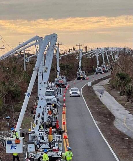 Due to the speed of the storm, there will be convoys coming to construct a pre-planned electricity grid recovery process even before the sun rises tomorrow. Convoys from every city, town and state from the east-coast to the mid-west. A glorious melding of dirty fingernails all arriving for the meet-up. Depending on your proximity to the bigger picture objectives at hand, you will cherish their arrival.
But first, there will be an assessment. The convoys will stage at pre-determined locations using radios for communication. Most cell phone services will likely be knocked out. Recovery teams will begin a street-by-street review; everything needs to be evaluated prior to thinking about beginning to rebuild a grid. Your patience within this process is needed; heck, it ain’t like you’ve got a choice in the matter…. so just stay positive.
Meanwhile, you might walk outside and find yourself a stranger in your neighborhood. It will all be cattywampus.
Trees gone, signs gone, crap everywhere, if you don’t need to travel, DON’T.
I mean CRAP e.v.e.r.y.w.h.e.r.e.
Stay away from powerlines.
Try to stay within your immediate neighborhood for the first 36-48 hours. Keep the roadways and main arteries clear for recovery workers, power companies and fuel trucks.
Be entirely prepared to be lost in your own neighborhood and town for days, weeks, and even months. Unknown to you – your subconscious mind is like a human GPS mapping system. When that raging Helene takes away the subconscious landmarks, I guarantee you – you are gonna get lost, make wrong turns, miss the exit etc.
It’s kinda funny and weird at the same time.
 Your brain is wired to turn left at the big oak next to the Church, and the road to your house is likely two streets past the 7-11 or Circle-k. You don’t even notice that’s how you travel around town; that’s just your brain working – it is what it is.
Well, now the big oak is gone; so too is the Circle-K and 7-11 signs. Like I said, everything is cattywampus. Your brain-memory will need to reboot and rewire. In the interim, you’re gonna get lost… don’t get frustrated.
No street signs. Likely no stop signs. No traffic lights.
Remember, when it is safe to drive, every single intersection must be treated like a four-way stop…. and YOU ARE GOING TO HAVE TO PAY ATTENTION. Even the major intersections.
You’ll need to override your brain tendency to use memory in transit. You’ll need to pay close attention and watch for those who ain’t paying close attention. Travel sparingly, it’s just safer.
Check on your-self first, then your neighbors. It don’t matter if you’ve never said a word to the guy in the blue house before. It ain’t normalville now.
Break out of your box and check on the blue house down the street too. In the aftermath, there’s no class structure. Without power, the big fancy house on the corner with a pool is just a bigger mess. Everyone is equally a mess.
The first responders in your neighborhood are YOU.
You, the wife, your family, Mrs. Wilson next door; Joe down the street; Bob’s twin boys and the gal with the red car are all in this together. If you don’t ordinarily cotton to toxic masculinity you will worship it in the aftermath of a hurricane. Git-r-done lives there.
Don’t stand around griping with a 40′ tree blocking the main road to your neighborhood. Figure out who’s got chainsaws, who knows how to correctly use them, and set about safely clearing the road. If every neighborhood starts clearing their own roadways, the recovery crews can then move in for the details.
Stage one focuses on major arteries… then secondary… then neighborhood etc. It’s a process. Oh, and don’t get mad if your fancy mailbox is ploughed-over by a focused front end loader who is on a priority mission to clear a path. Just deal with it. Those same front-end loaders will also be removing feet of sand from coastal roads. Don’t go sightseeing… stay in your neighborhood.
For the first 36-48 hours, please try to stay close to home, in your neighborhood. Another reason to stay close to home is the sketchy people who can sometimes surface, looters etc. Staying close to home and having contact with your neighbors is just reasonable and safer.
Phase-1 recovery is necessarily, well, scruffy…. we’re just moving and managing the mess; not trying to clean it up yet. It’ll be ok. There are going to be roofing nails everywhere, and you will likely get multiple flat tires in the weeks after the hurricane.
After this storm half of the people living near the Big Bend are going to fit into two categories, two types of people: (1) those with a new roof; or (2) those with a blue roof (tarp).
Keep a joyous heart filled with thankfulness; and if you can’t muster it, then just pretend. Don’t be a jerk. You will be surrounded by jerks…. elevate yourself. If you need to do a few minutes of cussing, take a walk. Keep your wits about you and stay calm.
Now, when the recovery teams arrive…. If you are on the road and there’s a convoy of utility trucks on the road, pull over. Treat power trucks and tanker trucks like ambulances and emergency vehicles. Pull over, give them a clear road and let them pass.
When everyone gets to work, if you see a line-man, pole-digger or crew say thanks. Just simple “thanks”. Wave at them and give them a thumbs-up. No need to get unnecessarily familiar, a simple: “thank you for your help” will suffice. You know, ordinary people skills.
Many of these smaller crews will be sleeping in cots, or in their trucks while they are working never-ending shifts. Some will be staging at evacuation shelters, likely schools and such. The need to shelter people and recovery crews might also delay the re-opening of schools.
 Once you eventually start getting power back, if you see a crew in a restaurant, same thing applies… “thanks guys”.
Same goes for the tanker truckers. The convenience stores with gas pumps are part of the priority network. Those will get power before other locales without power. Fuel outlets are a priority. Fuel is the lifeblood of recovery. Hospitals, first responders, emergency facilities, fuel outlets, then comes commercial and residential.
Remember, this is important – YOU are the first responder for your neighborhood. Don’t quit. Recovery is a process. Depending on the scale of the impact zone, the process can take days, weeks and even months.
Take care of your family first; then friends and neighborhood, and generally make a conscious decision to be a part of any needed solution.
Pray together and be strong together. It might sound goofy to some, but don’t be bashful about being openly thankful in prayer.
It will be ok.
It might be a massive pain in the a**, but in the end, it’ll be ok.
√ Andrew
√ Jeanne
√ Frances
√ Ivan
√ Charley
√ Irma
√ Ian
Now comes Helene.
.
One-third of Pinellas County without power at 10:30 pm.
Prayers and safety for those in the path. Sundance stay safe we need you
If any CTH readers need a contact well out of the area, let me know. Cell & internet is solid here in the far NE part of Washington State. More then willing to receive and pass on messages
So important.. during one storm a reader reached out with concern about a relative in a trailer.. It all came together somehow. Help where you can, even if it is a message.
Trailers . . . got to work hours late in California long ago after the base was hit by a down-burst that disc0mbobled the mobile home park.
Funny fellow from Georgia drawled “God Hates Trailer Parks!!”
Good times.
Funny 😂 🤣🤣🤣🤣🤣😂
Dear Oldretiredguy, you’re a keeper!
X1000, Sundance
√ Andrew
√ Jeanne
√ Frances
√ Ivan
√ Charley
√ Irma
√ Ian
Add to that list Georges, Wilma and Katrina and probably some others I’ve forgotten. Always lived on the Gulf coast from Louisiana to Key West
And Hugo in Charleston…
Already seen videos of the dinghy’s and jet skis rolling through flooded Fl streets with Trump flags on them 🤣👍🏼🇺🇸
But…but…. Camel toe is ahead , isn’t she?.
Lets go Brandon! LOL
The week of September 22 to 29, 1975 I was TDY to Tyndal AFB participating in a World-wide Rifle/Pistol Match. Hurricane Eloise struck just west of Panama City. It was rated the most destructive of that season.
Tyndal was evacuated, with the exception of us shooters. We were all USAF Security Police and were expected to stay and guard the base.
I still remember sitting out that storm in the base theater, which had 2 foot thick cement walls. There were moments when we all thought the whole building was going to blow away with us in it.
Phoon Party!
Closest I came to such was in Okinawa.
I was part of a Phoon Party in Vietnam in ’71.
Scarier!
How’d your excellence in competition go that time or did they even do that after the hurricane?
We were delayed for a couple of days, but continued the match.
There were guys there from every Air Force Command from all over the world, so they just couldn’t cancel it.
Good deal. I was only able to compete at the first level and got the rifle but drew a rattle trap of a Beretta mod 92 that wouldn’t hold within 6 inches so missed out on pistol.
In 1975 we shot S&W Model 15 Combat Masterpieces. .38 cal wheel guns.
I did carry a Beretta mod 92 in the Md State Police though…
I was referring to a 1993 Holloman, AFB regional competition.
I was not security police but was assigned to a
Cat 1 mobile resource and every operations person was also armed on deployments along with a permanent SP contingent. We carried both rifle and sidearm.
I was lucky to get opportunity to shoot that competition and probably should have applied for next level chance.
Maryland troopers are (at least were) very professional. Have a great evening sir!
W.O.W.
VERY SCARY! 😟
Michael
Yeah, Wima. Set her eye out on the top of the toilet in the corner bath in the house we were rehabbing in Loxahatchee, halfway between West Palm Beach and Lake Okeechobee. She came across the state from Marco Island on the gulf coast and was supposed to be a Cat 1 by the time it hit us. The eye went right over me with 110mph gusts on the wind guage. Watched the new metal roof we’d just finished flopping up and down at the sw corner, scared it was going to come off. The neighbor lost a front window and during the eye we managed to board it up and I just got back in our door when the other side of eye hit. Lucky the wind on the side of the loose roof rafter was coming from the other way and the roof held. We lost half a dozen newly planted palms but little else. The wife and kids were in a friend’s house a couple miles away that lost the pool screen but no other damage.
Yep,
Lived in Jupiter Farms at the time.
Camille, Katrina, Andrew, Hugo, George, Elaina, a few others, the Greek Alphabet year trifecta. lol
Seriously, best of luck. Stay safe.
Camille in 1969
Ike in Galveston
Camille, Isabelle, Fran up my way.
Here in Western NC we had torrential rain last night, some flooding. Light rain all day but supposed to start up again tonight. They say we will have tropical storm level winds tonight and tomorrow but when I look at that map it seems like it is drifting further west so maybe it will not be so bad. The tend to exaggerate here; I went out grocery shopping today and no problem but I know all the various back routes so I avoided potential flooding issues.
How’s it looking in Black Mountain area? Will be traveling there next week.
I didn’t go in that direction, but it is very close to me. By next week all shall be fine. The thing about Black Mountain is it is on the west side of the Eastern Continental Divide so the clouds or rain move west to east and when it hits the mountains it dumps the moisture…contrary to the Eastern side, much dryer. Rains and snows a lot more than here. and I am only about 20 miles away. But by next week…should be fine.
Good to know. I’ve seen storm is forecast to go just north along Tennessee/Kentucky border, then stall, drift east along NC/VA border towards Atlantic. So the area stays wet with heavy rains whole time through Monday-Tuesday, a lot of rain between now and then. Rivers will be running high. And that’s when I’ll be coming through.
Aftermath…if you’re still following this thread. Hope your well. Next week?
This happened yesterday in West Palm Beach, FL. Yes. People can be very stupid.
https://www.wptv.com/news/palm-beach-county/region-c-palm-beach-county/person-shocked-by-downed-power-lines-near-west-palm-beach-taken-to-trauma-center
I hope they get him to a burn unit…electricity does a phenomenal amount of damage within a body….in between the entrance wound and exit wound….
I could tell stories about human stupidity…
Don’t know outcome. He got out of his car, tried to move the line downed in the street out of the road. Got zapped, entangled. Nobody could help him, police and paramedics on scene, until they turned off the power. Sounds like it took awhile. Guy had current going through him a long time, surprising he was still alive to load into an ambulance.
Bad luck to interfere with natural selection, better to not do it.
“ Helene is moving toward the north-northeast near 16 mph (26 km/h). A significant increase in forward speed is expected during the next 24 hours.”
Am thinking the faster moving, the better…Get it going and get on out…
GIDDY-UP!
Best synopsis of the hurricane experience I have read.
5 PM advisory out now with winds up to 125 mph. Pressure down to 951 mb.
One thing that sticks out (we’re at some risk in the Madeira Beach area) is how closely this storm is following the modeled paths. There is plenty of room for surprises, but so far Helene is behaving as forecasted.
Ian, for example, was supposedly headed for somewhere around the Alabama/Florida border. Then it started looking like it might hit Tampa. Surprise! Ian took a hard right turn and hit in the Ft. Meyers region.
So as Sundance has warned, be prepared even if you seem to be out of the main effects of the storm. Hurricanes behave as predicted… until they don’t.
God Speed to all in harms way.
A line about “fuel”….just try and recover with solar panels and EV’s….
“Same goes for the tanker truckers. The convenience stores with gas pumps are part of the priority network. Those will get power before other locales without power. Fuel outlets are a priority. Fuel is the lifeblood of recovery. Hospitals, first responders, emergency facilities, fuel outlets, then comes commercial and residential.”
Drill Baby Drill…..
Be safe.
I believe FL made it mandatory a while back for all gas stations to have back-up power for the pumps. Won’t help when their tanks run dry but still, I remember having to drive more than 60 miles after Irma just to get gas for the generator after we ran dry.
ICE ICE BABY !!
Fill your rigs and gas cans now!
Sundance, Great advice. Once again.
Praying for all in Helene’s path; May God bless and protect you.
Our home group met tonight & is praying; Not one life lost!
Have relatives and friends in the Tampa area. They are ready.
Noted that this storm is apparently going to get to the Nashville area, and then just sit for a couple/3 days. We are in drought here in Middle TN, but it looks like this thing is going to end the drought in a manner that will probably generate a lot of flooding. Happy to note that our house in on high ground with zero risk of flooding….but not losing power at some point will be an unexpected treat.
Stay safe everyone!
I thought the Indian burial grounds always protect Tampa from major damage…?
No. Only Bradenton.
I heard the same thing 3 years ago about the Indian mound in Englewood…
Then came Ian…
Right now, the mound is about the only thing out of the water {Lemon Bay}…
Trust God. Fear not.
Thanks for all that Sundance…all of those in the path or radius stay safe be vigilant and be ready.
Praying.
Incredible livestreams.
Check out Matlacha Bridge. This is the one connecting Pine Island that collapsed during Ian in ’22
https://www.youtube.com/live/OqSFZo_lxXM?si=RiYtR_YDPjYrzBTT
Thanks lots for this link.
Absolutely startling amazing live action footage of Mother Nature at work in Florida
Y=I=k=E=S
The astounding “not-calm” before the arrival of the storm
Many thanks for that!
Awesome!
We were on that bridge two weeks ago marvelling at the response following Ian. Just incredible.
Looks Unwise to cross that bridge at 6:10 PM
Many good memories from that funky drinking village with a fishing problem.
Observed bucket trucks from Brunswick Canada southbound through Virginia today on the way to help restore power
If you’re young and smart, and you want to help people but you’re not sure what job you want, then you might consider being a meteorologist and predicting hurricanes.
A meteorologist has to be smart. You have to know math, physics, chemistry, and I don’t know what else. You have to be able to keep several things in your head at the same time (high pressure here, wind speed and direction there, the ocean’s temperature, etc., and all of these factors constantly change) – and say, “With all of these factors, I predict that the hurricane will travel such-and-such a path.”
And your prediction of the path will affect the safety of thousands of people. So yes, a meteorologist’s job is very important.
…and AI, based on huge, dedicated computer systems, is rapidly replacing them. The only meteorologist jobs in a few years will be those feeding basic research into the AI’s predictive algorithms. It’s one of the reasons the path predictions have gotten so much more accurate in the last few years. When I was a teen in Fl back in the early 60s, the safest place to be when a hurricane was coming was exactly where it was predicted to hit in three days. They were notorious for routinely being as much as 200+ miles in error.
It’s coming directly over me in NW Ga. We’ve had downpours for 2 days with some flooding due to severe drought. Winds up to 50mph predicted Fri. My daughters business closed early and some schools are closed. Grocery stores are packed. I think it’s over reacting as far north as we are, but…🤷♀️🤷♀️🤷♀️
I live in Jefferson ga area and work in flowery branch ga at a grocery store. What a mess.
I am near Blue Ridge. We are staying in the basement overnight.
Do people here remember Katica? She lives in St. Marks and is now in Tallahassee. She is facing this beast head on.
Hope she stays safe and the storm weakens sooner than predicted.
Many people claim that the dockworkers will strike on October 1st
If the strike lasts any long length of time, it will cause major havoc in supply chains for months for months.
Please keep this clearly in mind the next time you go grocery shopping
Supplies may not be available in all parts of the country for a long time
Always thought it would be good to have a practical bicycle available. Anyone with halfway decent condition has a 10-25 mile radius of action, and more of course if you want out. Obviously won’t help with 3-6′ of flooding in an immediate area, but if you can avoid that you have some mobility.
Your description reminds me vividly of the aftermath of Andrew.
I remember an entire modern concrete 2 story indoor shopping center that was reduced to knee high concrete block wall remains. Miles of shredded wood houses and tree debris blocking access. Constant waves of rain and humidity in the aftermath soaking everything. Cell phones out for weeks. The governments local, state, and fed were totally unprepared for the amount of damage. Snakes, gators, crocs, canals and calf-high swamp water everywhere that made the canals blind until you stepped or drove into one …and dear god gerty, the mosquitoes. The stench of dead animals was overwhelming. The cops and military doing rescue and body recovery had horrid tales but there were an amazing number of survival tales as well.
Almost a year later I drove through the area again on my way to the Keys with my family …still a shredded wasteland.
You just don’t know until you know. Then you still don’t believe it.
The same will happen tomorrow in the bend, but unlike Andrew, Florida and FEMA are much better prepared these days and people have had days of warning. It will be bad …few structures survive a 20ft surge and 130mph winds …but hopefully common sense prevails and most get out.
I hope the area recovers quickly. The panhandle, except Tallahassee, is a strong red area and often makes the difference in who carries the state and fed votes. We need it to carry FL for Trump and Scott.
Thank you for posting this. I have been curious about the long term aftermath of Andrew for decades
Not anywhere near Florida when it occurred, but that afternoon, I had BAD~BAD not at all good, but downright nasty premonitions about Hurricane Andrew and Florida
Such bad premonitions I couldn’t sleep that night.
In the the wee hours of that ghastly overnighter, at the top of the hour there’d be only a one minute tiny report about the dangerous Hurricane Andrew .
NO real news at all, for hours
I stayed in a silent state of pure prayer for hours, with the radio on all night long. I was in the Midwest and finally at 4am CST the local affiliate of CBS started a live broadcast direct from Florida where conditions as you well know were violently extreme.
And then there were the following weeks and weeks in the aftermath that sounded just awful.
Years later, online, I read many Floridians firsthand accounts of how they survived that horrible night and how long it took cities and towns to recuperate
I still wonder to this day whether the Floridians who believed this was an early Weather modification event were correct
Then “Isaac” on the eastern side of FL in a couple of days?
https://www.nhc.noaa.gov/gtwo.php?basin=atlc&fdays=2
Oh no… Say it ain’t so!
Prayers to all in the path🙏🙏🙏🙏🙏
WATCH: Man with a TRUMP FLAG rides through Hurricane Helene flood waters down in Florida! 🇺🇸
HOLD ON, HE’S COMING!!
I’ve been watching the YouTube channel “Ryan Hall Y’all” all afternoon. Helene is now cat 4, sustained winds of 130 mph, with possibility to upgrade to cat 5 based on hurricane hunter flight data. This is an extremely dangerous storm…catastrophic at best. If people have not evacuated, they most likely will not survive. They’ve been instructed to write their birthdate and name on their bodies with indelible ink.
There have been tornado warnings in FL and surrounding states all afternoon.
RYAN HALL ,Y’ALL “🔴LIVE – Major Hurricane Helene Coverage With Storm Chasers On The Ground – Live Weather Channel…” on YouTube
https://www.youtube.com/live/XTnlp7qrTYg?si=rRnC-DDEIzHM0kpG
yes that’s him.
He’s great. Especially the way his team assists the disaster victims with
CA$$H and warm hot meals and cleaning supplies. Lots of people contribute lots of money to his charity. Some of the videos about clean up efforts by as team are genuinely awesome to watch. I’ve seen people burst into uncontrollable tears when staring at the check handed out freely to them. Some people scream in disbelief. I would too. After all after losing your home to the Weather Gods, who expects to have a stranger hand hem a check for 10 grand.,.. a “little” something to help them out until insurance and FEMA assist.
Class act.
I saw the ID body thing on a news cast, quite sobering. I hope my family will stay safe, my sister had to ID her child via a tattoo years ago. I do not want her to have to do that again.
Stay safe everyone🙏🏻🙏🏻🙏🏻
Helene As of 6:20 PM Cat 4 hurricane
684
WTNT64 KNHC 262218
TCUAT4
Hurricane Helene Tropical Cyclone Update
NWS National Hurricane Center Miami FL AL092024
620 PM EDT Thu Sep 26 2024
…HELENE NOW AN EXTREMELY DANGEROUS CATEGORY 4 HURRICANE…
A NOAA Hurricane Hunter aircraft currently investigating Helene
recently found that the maximum sustained winds have increased to
130 mph (215 km/h). The minimum central pressure has also decreased
to 947 mb (27.96 inches) based on dropsonde data.
SUMMARY OF 620 PM EDT…2220 UTC…INFORMATION
———————————————-
LOCATION…28.0N 84.5W
ABOUT 120 MI…195 KM W OF TAMPA FLORIDA
ABOUT 165 MI…265 KM S OF TALLAHASSEE FLORIDA
MAXIMUM SUSTAINED WINDS…130 MPH…215 KM/H
PRESENT MOVEMENT…NNE OR 25 DEGREES AT 23 MPH…37 KM/H
MINIMUM CENTRAL PRESSURE…947 MB…27.96 INCHES
And it is still intensifying…pressure 949.7 MB.
Horrifying.
Linemen staging in Pensacola.
God bless them, and may His voice calm the storm 🙏🏻
Hi Betsy,
Nice to see.
God Bless FP&L
They Are Really Good!!
Truly Sundance, you’re an *Oak*.
To all of you in this thing’s path I bid you all blessings and Godspeed from gray-ol’ England, where it’s just a little piddly and blustery at the mo’…
…- Y’all are the *very* dictionary definition of ‘Intrepid’ to be putting up with blows like these year in and year out… – This Brit’s mind boggles and is duly humbled!…
SD. Keeping you and your family in our prayers. May you all be kept safe as the hurricane blows by.
Oh My Goodness. … I’m glad I read the article a second time.
I had missed this choice tidbit:
“If you don’t ordinarily cotton to toxic masculinity you will worship it in the aftermath of a hurricane. Git-r-done lives there.”
.
.
That’s just rich!!!!! 🤣🤣 🤣
Thank you!
I luv it.
From Ryan Hall Y’all: – Tornardo warning for Calhoun, Baker, Terrel and Dougherty counties in Georgia.
Now also tornado warning, Hardee and Charlotte counties, FL.
…And Ware and Clinch, GA
Thanks for your articles. We evacuated on Tuesday based on your Monday post. Not sure when we will return.
full text of tweet (emphasis added):
Maybe I missed it, but over 40 million Americans are about to be impacted by a CAT 4, massive hurricane.
Did Harris or Biden make any public statement this evening (not press release, public statement) to the American people about this emergency?
I know they spent time with Zelenskyy and made public statements about Ukraine, but anything about our country at a time like this?
I certainly hope so.
Maybe I just missed it.
Haven’t heard a peep from the WH. Yet. Of course, we know nobody’s home.
It’s getting *really* windy over here on the Atlantic Coast in NE FL.
Could barely get the door open when I had to go outside for a sec.
Howling and whistling wind.
They weren’t lyin’ when they said this wind would have a 400 mile reach!
Tornado warnings about 10 miles to the west of us.
yep. We’re in NE Coastal Florida. The water in our toilet bowls are already sloshing around.
Keeping all in the path in prayer. God bless and keep you!
Nope… It’s a small storm that has been made much to do about. I fear for the day a deadly storm comes through after everyone has cried wolf so many times.
Daytona Beach here…not much going on. Looks like we missed it so far. (some rain/wind but no biggie)
https://www.wesh.com/weather/radar
NHC/NOAA
9:00 PM EDT Thu Sep 26
Location: 29.1°N 84.2°W
Moving: NNE at 24 mph
Min pressure: 941 mb
Max sustained: 140 mph
Ryan Hall, Y’all you tube channel is livestreaming the now category 4 hurricane with live links to various storm chasers and stationary webcams in various cities:
Not sure where in Florida, Georgia and places north our fellow Treepers are, prayers that everyone and their families are able to stay safe, and dry.
Just a touch of humor in a dire situation (20 foot storm surge in some areas – that’s almost 3 stories high…)
My son is a lineman poised to deploy to where the power must be restored. He was there for Michael (so many other summer and winter storms). These guys shrug it off as “just another day at the office” . Such courage. Please consider praying for them as they undertake this dangerous and vital work. Thanks. Treepers 🙏
That’s the personalized ringtone I have set for his calls 😂.
Oh how sweet!
Watching Ryan Hall and – help a Brit out here Treepers – what’s the deal with Waffle House?
…- Landfall in ~15-20 minutes @Horseshoe Beach.
Not sure, but I *think* that Waffle House is famous for not shutting down during bad weather.
So if they shut down, it’s a sign that the weather’s *really* bad.
Maybe others can chime in on this.
…- Ah, gotcha! – thx. sunnydaze.
…- Waterspout heading ashore Tybee Island GA – Atlantic Coast – expected to head on towards east side of Savannah.
Waffle House is an American style 24 hour a day, 7 days a week open for business short order style diner. They emphasis breakfast but have other offerings. They are a “chain” so are spread out all over the country.
They are usually the last business to close down and the first to resume operations due to any emergency.
Bit of Americana really but a strange place to be on early Saturday or Sunday mornings in the wee hours after the bars and clubs close down.
Thankyou Monticello – I was wonderin’.
“Bit of Americana really but a strange place to be on early Saturday or Sunday mornings in the wee hours after the bars and clubs close down.”
…- I dunno – sounds kinda cosy… 🙂
…- Landfall imminent – just south of Perry (Keaton Beach/Fish Creek(?)). – Be safe everyone.
***chin Hurricane!
We hunkered down in JAX area. Looks like we’ll miss the brunt of this beast.
Tornado warning in effect for St Johns County through 1800 Friday.
Hoping like all get out that Helene has the good sense to destroy mail-in ballot storage areas in GA!
The wind in this storm is sooo fierce and far reaching.
Just stepped out onto my screen porch on the Atlantic Coast of NE FL- and nearly everything out there was blown across the porch from South to North!
If the ‘cane was on this side, I would’ve moved all that stuff off the porch. But I have *never* had to move stuff off my porch because of a ‘cane in the Gulf.
I cannot imagine how bad it is over on the Gulf side, or farther instate.
Wishing you and yours safety and security!
Tallahassee bracing for major impact. A first in the City’s history. Greatest danger from falling trees.
Just know we’re thinking about you.
Record-breaking storm surge flooding predicted to devastate many communities. Flooding could cause more power outages.
https://www.nesdis.noaa.gov/imagery/interactive-maps/the-world-real-time
This Helene is a beast. This is a NOAA real time interactive map link. Focus in on the east coast US.
Apparently outer rain bands reaching us in SW Virginia now which is approximately 660 miles away!
Right now we have a tornado warning not too terribly far away that is moving in the odd southeast to northwest direction.
A wild night indeed even though our hazards are paltry compared to the Bend area of Florida.
-Yeah, no sh*t: – ‘Nother tornado warning just announced for Roanoake and Franklin counties, VA.
I’ve heard that noise a hurricame makes. It was during Ivan and we were 70 miles inland right in the path. I would have evacuated. Husband and father of kids said stay. So we stayed. I was okay with that decision other than the countless minutes spent in the roar, hunkered down behind a sofa with my four children around and under me. I remember that crystal clear though its been over 20 years.
Ryan Hall just updated the live stream cuz it was about to tick over the 12-hour mark. Here’s the new link: