[National Hurricane Center Data] As of 11:00am ET Tuesday, Hurricane Ian has maximum sustained winds of 115 mph [Category 3]. Ian is anticipated to continue strengthening in the next 24 hours as it enters the Gulf of Mexico as a major hurricane [Cat 3+]. All west coast Florida residents from Bonita Springs to Tampa should use Today to finalize their hurricane preparations.
Today is the last good weather day to finish your preparations and secure your property. Do not be alarmed but do take this hurricane seriously. This is not a ‘wait and see’ type storm. All reasonable precautions should be completed today, and all coastal residents are urged to pay close attention to local officials for evacuation orders. Each locality is different, each coastal locality has a zone of potential flooding and storm surge. As a general rule, hunker down from wind – but evacuate from water.
[NHC] At 1100 AM EDT (1500 UTC), the center of Hurricane Ian was located near latitude 23.0 North, longitude 83.5 West. Ian is moving toward the north near 10 mph (17 km/h), and this motion is expected to continue today. A turn toward the north-northeast with a reduction in forward speed is forecast tonight and Wednesday. On the forecast track, the center of Ian is expected to move over the southeastern Gulf of Mexico in a couple of hours, pass west of the Florida Keys later today, and approach the west coast of Florida within the hurricane warning area on Wednesday and Wednesday night. (more)

Official projections now put the storm further east and slightly south, just off the Florida southwest coast on Wednesday night, with the potential for a 24-hour duration cycle. That is an alarming amount of time for a major hurricane to be centered near or on the coast. That is a minimum of two tidal cycles, which will make a big difference from prior hurricanes in terms of flooding and the potential for a historic storm surge into inland waterways.
Hurricanes can be frightening; downright scary. There’s nothing quite like going through a few to reset your outlook on just how Mother Nature can deliver a cleansing cycle to an entire geographic region. If this storm rests on/near the coast for the projected duration (24 hrs), things could be much more sketchy than other hurricanes. This possibility is not something to dismiss. No one in Florida has a reference.
The geography on the south side of the storm faces the possibility of inbound wind and water for two tides, very uncommon. Additionally, with outbound water limited by the pressure of inbound tides, the Peace River, Caloosahatchee River, Charlotte Harbor etc will flood, potentially at a historic level. Let us hope the official forecasts are wrong, but we need to plan for this. Projected rainfall is up to ten inches.
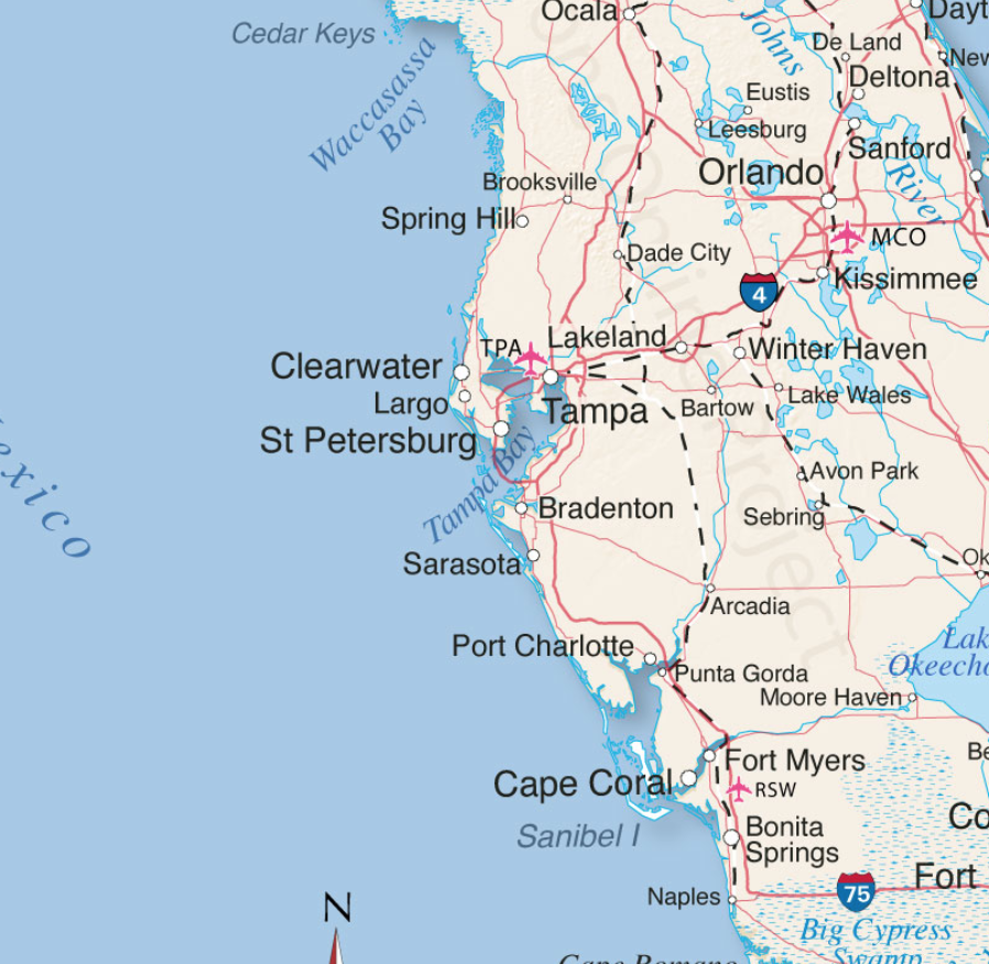
The deepest water will occur along the immediate coast near and to the right of the center, where the surge will be accompanied by large waves. Surge-related flooding depends on the relative timing of the surge and the tidal cycle, and can vary greatly over short distances. For information specific to your area, please see products issued by your local National Weather Service forecast office. [HERE’S LINK] Pay attention to local officials.
Do not panic, but work your plan.

Dangerous coastal area storm surges are now predicted from Fort Myers north into Tampa Bay (south side of storm). Please outline your communication plan with your family. Select a specific person outside the area to be your immediate contact. That person then relays information to the rest of your family. Please do this [Example Why].
Right now, you are in control. Do not be alarmed – but take every preventative measure your individual situation needs. Work your hurricane plan and stay focused on what you do control. Work the plan, step by step and focus on what is in front of you. Ignore the dark imaginings and turn off the national media. Pay attention to your local officials and local media.
Finish your laundry. Sanitize and stage your water storage. Inventory your supplies. Organize your tools. Fill your freezer with water jugs to take up room and freeze. Test your generator. Stage your extension cords. Stage your battery powered devices. Test your weather radio. Take small steps to prepare. Secure your home. You are in full control. Today is the day to finish all preparation tasks.
The #1 priority is to keep calm. Keep stable. If other people around you are panicked, do not let it impact your plan. Stay focused. Stay organized. Stay in control. I cannot emphasize enough how important it is for everyone around you and your family. Everything is replaceable, except you and your family. We have a lot of Treepers in the path of this storm. If you need assistance, use the comments section of any ‘Update thread’ to reach out, or use the email address in the upper right of the site.
DAY THREE (Tue/Wed)
- Get Storm Update
- Re-Evaluate your Supplies based on storm update
- Finish last minute preparation
- Plan for a minimum of THREE DAYS without power
- Assist Your Neighbors
- If Needed – Evacuate Your Family
.
Communication is important. Update your friends and family contact list. Stay in touch with family and friends, let them know your plans. Select a single point of contact for communication from you that all others can then contact for updates if needed.
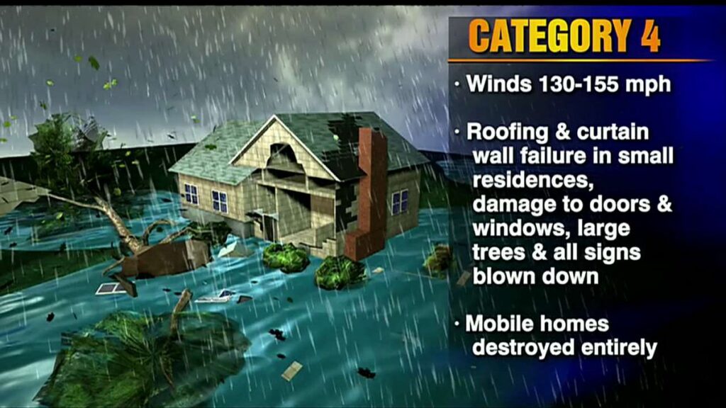
 Telephone and power poles, yes, even the concrete ones, can, and likely will, snap like toothpicks. There’s a sound when you are inside a hurricane that you can never forget.
It ain’t a howling wind, it’s a roar. A damn scary raging roar that just won’t quit….
It will quit… eventually… but at the time you are hearing it, it doesn’t seem like it will ever end.
A constant and pure rage of scary wind that doesn’t ebb and flow like normal wind and storms… hurricane wind just starts and stays, sometimes for hours.
This type of wind is relentless and damn scary. It takes you to that state where you begin to doubt things, it just won’t let up.
And then, depending on her irrelevant opinion toward your insignificant presence, she stops.
Then silence.
No birds. No frogs. No crickets. No sound.
Nature goes mute. It’s weird.
We have no idea how much ambient noise is around us, until it stops.
Oh, if she wants, she’ll keep dumping buckets on you as she wanders away. Buckets. Not pails, garbage can size buckets. After the scour, yup, nature too has a rinse cycle.
Prayers for all those in Ian’s path.
Pray together and be strong together. It might sound goofy to some, but don’t be bashful about prayer – it works.
It will be ok.
Last point, housekeeping. To ensure continuance of communication, CTH has auto-scheduled posts set up throughout the week which will run automatically without any need for human data entry. [ie. the website is secure and will function as normal – and site admins are disbursed throughout unaffected time zones] Other than my absence (hopefully sporadic), you should not see any disruption. Stay safe and God Bless.

So Sundance is headquartered in the area of the hurricane? That would explain the blackout of a hugely important story from Europe .. sabotage and serious damage to both Nordstrom pipelines. And the finger seems to point to the Biden Misadministration
according to Twitter:
I swear I heard the Moron say in a video ‘I did it.’ Of course you can’t depend on what he says most of the time, but I wouldn’t put it past him.
Sabotage of this sort is a Casus Belli.
As for who done it, near certainty it was done on the orders of the WEF.
Follow the money. Look at futures trades, someone somewhere knew and it will be obvious.
hope the Mucky Duck is ok
Sundance
God speed and be safe. Thank you for all you do
Tea
for any/all of you in Florida, keep listening for the birds. When you no longer hear them, it means they have left and the storm will be there soon. prayers for all in harm’s way.
We are directly in Ian’s path. About 15 miles inland. We have elevation so flooding is unlikely. Our concern is the wind. 100 ish mph for nearly 6 hours.
Sent wife and daughter to friends in St Lucie. My son (22) and I will ride it out. Jesus is our refuge.
That is so correct about the birds.
I have 3 hens and the other day we had a crazy thunderstorm come through. 50mph wind gusts.
My girls went into their coop about 10 minutes before the storm hit.
They never go into the coop until sunset. Never.
so yes listen to the birds.
Prayers from North Georgia 🙏🏻. We serve a mighty God.
Please check in as soon as you can after the storm and let us know y’all are okay.
Prayers from Kansas for everyone in the hurricane path!
For those that have moved from NYC to the Tampa area, this is no Hurricane Sandy.
“Peace. Be still.” If not the wind, then peace, stillness and safety for everyone in Ian’s path. You’re all in my prayers.
Thank you, Sundance and mods, for all you do.
LIVE: Hurricane Ian latest Florida updates as Tampa and Sarasota fear direct hit | LiveNOW from FOX
https://commoncts.blogspot.com/2022/09/live-hurricane-ian-latest-florida.html