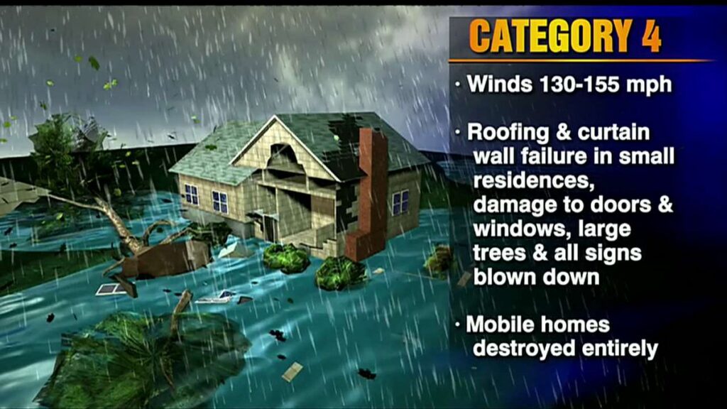
National Hurricane Center Data Here – After two years of relatively uneventful hurricane activity, and with two years of massive migration into the state since the COVID pandemic, there are millions of people potentially going to experience their first hurricane. Thus, Florida emergency officials are being proactive in their alerts.
There is no cause for alarm, but the unspoken motive for officials to more firmly emphasize preparation is related to this ‘new resident’ dynamic. In the background several FL Civilian Emergency Response Teams (CERT) are now preparing. Due to the confluence of events, all are is taking this storm seriously.
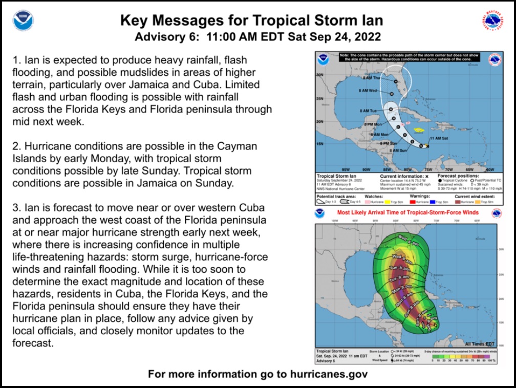
TD #9 is now Tropical Storm Ian, soon to be Hurricane Ian. – “At 1100 AM EDT (1500 UTC), the center of Tropical Storm Ian was located near latitude 14.4 North, longitude 75.2 West. Ian is moving toward the west near 15 mph (24 km/h), and this general motion is expected to continue through tonight. A turn toward the northwest is forecast on Sunday, followed by a north-northwestward turn on Monday and a northward motion on Tuesday. On the forecast track, the center of Ian is forecast to move across the central Caribbean Sea today, pass southwest of Jamaica on Sunday, and pass near or over the Cayman Islands Sunday night and early Monday. Ian will then approach western Cuba late Monday and emerge over the southeastern Gulf of Mexico on Tuesday.” (link)
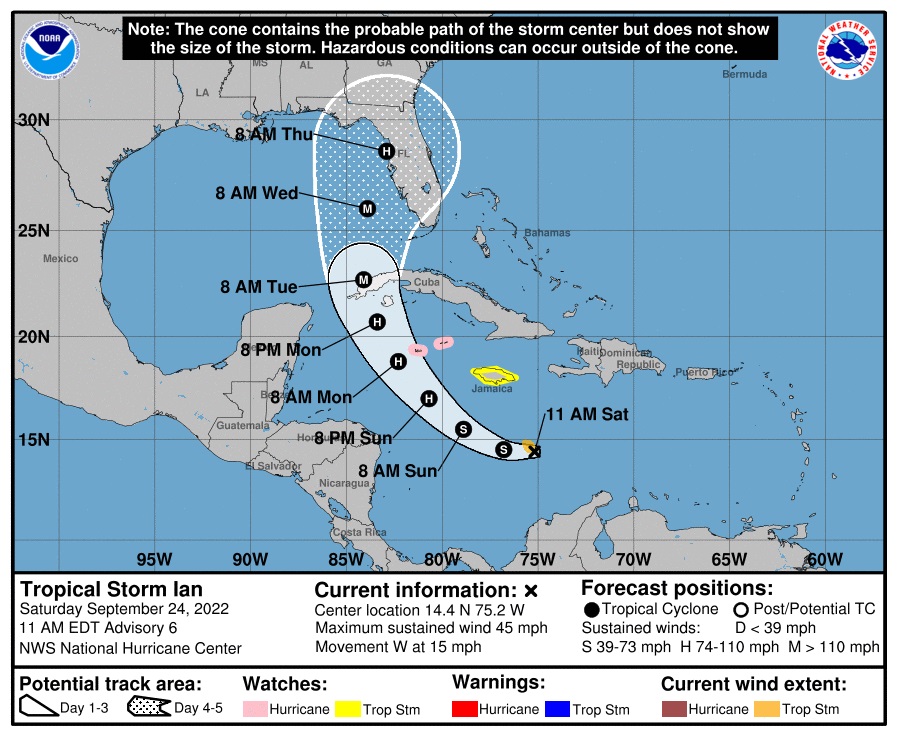
The general forecast path has not changed much in the past 12 hours, but the timeline has slowed as the storm slowly gathers strength. We are now likely looking at a Wednesday night landfall (projected). There is a very wide cone of uncertainty and also more time to prepare.
In its current location, every hour that Ian spends traveling ‘west’ generally means a land impact further ‘north’. When Ian shifts more to the North the computer models for the impact cone will narrow; for now, the entire West coast of Florida should be keeping an eye on this. Ian looks a lot like Charley (’04) with the currently projected path.
Charley had everyone from Ten Thousand Islands (south Naples) to Tampa paying attention as it wandered to the North paralleling the Florida coast. Charley took a turn just north of Fort Myers, crossed Captiva Island and went northeast directly into the Port Charlotte, Punta Gorda area. Ian will likely not parallel Florida as close because it will be further west in the Gulf of Mexico as it travels North; however, the bend or turn to the east will likely be a similar northeast arc.
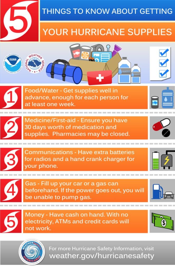
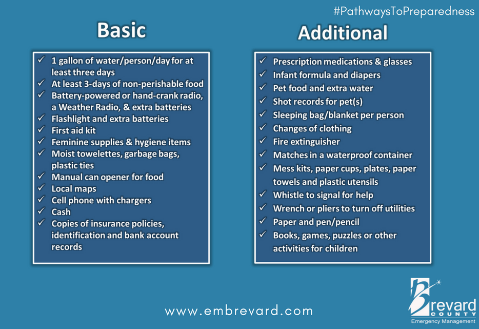
With this much advanced notice residents along the west coast of Florida should begin reviewing their prior supplies and updating their hurricane preparations. Much could change over the next 48-hours, but a review of supplies and locating stored material is a prudent approach.
Check your hurricane supplies of shelf-stable food, water, medicine and don’t forget pets. Prepare for the worst and hope for the best. Everything is replaceable, except you and your family. We have a lot of Treepers in the path of this storm. If you need assistance, use the comments section of any ‘Update thread’ to reach out, or use the email address in the upper right of the site.
Right now, you are in control. Have a solid plan, work that plan – stay busy, and don’t get caught up in the hysteria. Try to avoid national media hype. Stay updated via your local news stations. Monday afternoon/evening looks like the key day impact zones will be identified. Reach out to your neighbors; touch-base and check to see if they are okay or need anything. Community restoration begins before the storm arrives. Look out for each-other.
Regarding any evacuation plan, please pay attention to your local officials who will be coordinating with state Dept. of Transportation. As the path and impact zone of the storm becomes more predictable your local officials will alert to best route(s) for evacuation.
For those in the cone of uncertainty; remember, planning and proactive measures taken now can significantly reduce stress in the days ahead. Plan when to make the best decision on any evacuation (if needed) consider Monday the decision time-frame. As a general rule: take cover from wind – but evacuate away from water.
DAY ONE (Saturday)
- Determine Your Risk
- Make a Written Plan
- Develop an Evacuation Plan
- Inventory hurricane/storm supplies.
- Withdraw cash based on plan/need.
- Get gas and storm supplies
DAY TWO (Sunday)
- Get Storm Update
- Assemble and purchase any missing Hurricane Supplies
- Contact Insurance Company – Updates
- Secure Important Papers.
- Update/upload your phone data.
- Strengthen and Secure Your Home
- Discuss Evacuation Decision with your Family.
- Fill freezer with 3/4 full water jugs.
DAY THREE (Monday/Tuesday)
- Get Storm Update
- Re-Evaluate your Supplies based on storm update
- Finish last minute preparation
- Plan for a minimum of THREE DAYS without power
- Assist Your Neighbors
- If Needed – Evacuate Your Family
.
Communication is important. Update your friends and family contact list. Stay in touch with family and friends, let them know your plans. Select a single point of contact for communication from you that all others can then contact for updates if needed.
Today/tomorrow are good days to organize your important papers, insurance forms, personal papers and place them in one ‘ready-to-go’ location.
Evaluate your personal hurricane and storm supplies; update and replace anything you might have used. Assess, modify and/or update any possible evacuation plans based on your location, and/or any changes to your family status. Fill car with gasoline. Review prescriptions, refill if needed.
Check your shutters and window coverings; test your generator; re-organize and familiarize yourself with all of your supplies and hardware. Check batteries in portable tools; locate tools you might need; walk your property to consider what you may need to do based on the storm’s path. All decisions are yours. You are in control.
Consider travel plans based on roads and traffic density. Being proactive now helps to keep any future stress level low. You are in control. If you have pets, additional plans may be needed.
One possible proactive measure is to make a hotel reservation further inland that you would consider evacuating to. Follow updates of the storms’ progress; make reservations tomorrow (or Monday latest) if determined; you can always cancel if not needed. It is better to have a secondary evacuation place established in advance. Being proactive reduces stress. Even if you wait until much later to cancel, it is better to pay a cancellation fee (usually one night charge) than to not have a plan on where to go. Trust me, it’s worth it. Protect your family. Make the booking decision in the next 36 hrs.
♦ Look over the National Hurricane Center resources for planning assistance.
♦ Also a great resource – CREATE A PLAN
Solid advice for those in the path.
So far all of Fl is in the path, but it center line still has a bead on our house!
Slight shift westward, pushes cone slightly north
Stay safe, Sundance.
Godspeed, Sundance. Prayers for all in effect right now.
DeSantis should send the storm to Martha’s Vineyard.
They already have enough blowhards there 🙂
Don’t go to the Walmarts down here.
I said to my wife before she went.
The woman just can’t help her self on the weekends.
Geeze, it’s as if people are not ready for the “other” more significant and deadly global meltdown in a few months.
But, SD is right…there are a literal ton of noobs and illegals in my neighborhood. They’ll probably perk up tomorrow when I fire up the generators and test for fuel/oil leaks etc. Completely cycled the solar backup batteries this morning before dawn–bringing off of the float charge (hint: there is no sun before/during/after hurricanes).
You people up in Tampa/Cedar key/etc…keep your head on a swivel because it’s looking like ground zero right now.
(hint: there is no sun before/during/after hurricanes) ….and sometimes that has to be pointed out….
Like this line I saw yesterday in some lengthy list of “things to think about”: If you stay or return home without power you will also not have a/c. …..
Seriously, there is something I don’t understand–telling everyone to have 30 day supply of RX meds on hand. I only have two minor RX meds and, due to insurance restrictions, I can’t refill either one of them until I’m within a few days (according to their records) of running out. If I am down to a two week supply, I would not be allowed to order a refill. I often do not have a 30 day supply on hand and have no way to get it.
I thought those kinds of limitations originated with the insurance companies.
There are overrides for emergency fills that are typically allowed with disasters.
….did not know that….thanks.
Sharon: also if you were going away to a far off place for say 3 months or longer even, doctors often will prescribe for longer “for vacation supply” or “for travel supply”.
You might ask your pharmacist and your doctor about their experiences doing this.
You may be able to ask you doctor for a 90 day supply if they are maintenance meds you take on a daily basis.
I had my changed to that for convenience. But it works out good for times of disaster
Wondering if the left wing pharmacies then have to call the left wing RX drug plan to get the okay to fill Rxs ahead of time (yes, they would have to get their okay)…. and pray tell, how long would that take???? Likely not until after a disaster has occurred.
Unfortunately, that’s the way our government is run: Not preemptively, but always in CYA after the fact.
The governor has declared a state of emergency in Florida. I believe that means they can override refill too soon rejections on noncontrolled meds. Under normal circumstances, some plans even reject vacation overrides and the customer has to use a discount like Goodrx or Singlecare, or do without. Walmart really can’t be beat for going outside insurance on common generic maintenance meds though.
Dealing w/hundreds of people slamming the pharmacy at once is not something I want to deal with.
Talk to your Doctor about creating a 60 day “cushion” for emergencies. However, be willing to pay full price at the drugstore to avoid the insurance company. The insurance company is not obligated to prepare you for emergencies; you are!
As a health care provider (recently retired) the pharmacies are REQUIRED to bill your insurance company first, even if you choose to pay on your own. When/IF they get the denial, then they can bill you.
Bottom line: the healthcare industry, including the pharmacists are owned by the government.
The government calls the shots (literally). And they have extended their ownership to include calling Ivermectin, Hydroxychloroquine, and any other potential Rx drug to be spoken, “misinformation.”
I have gotten Ivermectin filled by two noncorporate pharmacies and I did not put it through insurance. You just have to find a noncorporate dr.
Some of the meds have prices that are prohibitive. Affordability will be a problem.
If your doctor is cooperative, get him/her to give you a goodRX prescription and get it filled somewhere like Harris Teeter. You will have to pay full price for it but the goodRX prescriptions are better priced. Pay cash and the insurance companies will have no reason to object.
You can also self-pay for your prescriptions. If this is cost prohibitive, check out Good Rx or similar services for discount codes.
I skip doses every so often so I have my prescription medicines.
I once brought the same question up at a Red Cross training and the instructors were stumped, so those of us in the class decided it is best to do our own supply on hand.
Things are very calm and orderly at the various Walmart locations in Lee County ( Ft. Myers – Cape Coral area ). Everyone is in good spirits and no panic, just normal times in SW Florida.
.
Some folks are out fishing and going to beaches as they normally might.
.
Only the Lord knows at this point where “ground zero” will be.
Here’s hoping to a dramatic shift in the hurricane’s path and ground-zero is Washington, D.C.!
We are every update.
Akindole, I would be right there with your wife. We are made of the same shopping temperament.
With this information being provided by NOAA you can bet the accuracy will change many times
Joe Bastardi is who is needed for the most accurate tracking.
He’s the man..👍👍
You bet he is, Jim. Rah, on the Open Thread we commment on, has shown a chart or two, but he says he’s waiting to see what Joe says.
When I was living in the UK in ’87, I think it was, the BBC’s resident weatherman, Michael Fish (a more unappealing man I could not think of) was in the middle of a weather report telling one and all how delightful the weather was and would continue to be.
In the middle of this welcome report, he told the viewing audience that he’d just had a phone call from a woman somewhere in the south of England who reported that the moment he was delivering his forecast, she was looking out her window at torrential winds and rains…and all around her house power lines were coming down, and trees were being uprooted.
Instead of backing down and taking her word, the imbecilic arrogant, full of himself fool doubled down and actually ridiculed her. And he stated that that couldn’t possibly be happening because why?
He was Michael Fish, and he was never wrong.
But he was horribly wrong twice. In fact the worst, most damaging storm to hit the south of England was going on, and the next day much of that part of the country lay in terrible ruins, flood everywhere. Many lives were lost, all for his ineptitude in not even forecasting it.
I’ll never forget it.
Betsy, check out http://www.windy.com. You can watch the storm as it progresses.
Be sure to click on the red arrow at the bottom left hand side.
👍
I will, Dixie. Thank you!
Also check out Mike Morales.
Great site!
Joe is the best pro and Mike’s Weather Page is the best amateur.
That’s additional info I didn’t know, Lindy, as far as amateur forecasting goes. Thank you.
Sanjac: The storm will most certainly be diverse, equitable and inclusive, in accordance with federal regulations and NOAA’s Zero Tolerance Policy.
I hope …really pray…it doesn’t come to mass evacuations. But should it, here comes the test case for the reliability or not of EVs on such a scenario.
Do you think most Floridians have EV’s? I know one person with one.
Where could #Ian hit Florida?
@wx_tiger
offers some analysis.
Scenario 1: Keys and South Florida (5% chance)
S 2: Southwest Florida (30% chance)
S 3: North of Tampa and faster (35% chance)
S 4: North Florida and slower (30% chance)
SD and Admin… your preparedness advice has been amazing since last spring.
God Bless all of you… please stay safe.
Prayers for all Floridians.
Stock up on SPAM and Vienna Sausages. Brings me back to Guam, Sideways flying coconuts and Typhoons, as they call them in PAC.
I just retrieved my daughter from a year in a camper right off Tampa Bay. My prayer for her during that year is now my prayer for those in the path: Lord please keep (them) safe!
We are now in the cone. Hurricane Michael put a whooping on us 4 years ago so we have a TON of weak, dead trees that will likely destroy the power grid again……… if it comes thru here. Won’t take much to topple the weak trees.
I went to take my dog for a walk yesterday on a state trail (in Central Florida). We didn’t get very far due to standing water from all of the recent rainfall we have had. Many areas in the state are already saturated. Additional rainfall from a hurricane is going to cause flooding inland too.
I’m in Cocoa Beach. We’ve had several nights of heavy rains. There is already a lot of water standing here, too. I’m praying for everyone. Be wise and be safe. Don’t forget about your pets!
Haven’t been to Panama City since before Michael. How is the recovery over there?
We have only been the PC a few times for Dr appts and such but it looked like our area… mostly cleaned up.
The general forecast path has not changed much in the past 12 hours, but the timeline has slowed as the storm slowly gathers strength.
The center of the cone of uncertainty has moved nearly 150 miles north of the initial issue of the track. And the cone of uncertainty is still as large as it was before. I would not be surprised at all to see this storm come ashore along the pan handle.
As per Levi Cowan the situation is complex with multiple factors influencing the steering currents. Because of this modeling the track of this storm is more difficult than is often the case. The bottom line is the further west this storm moves before turning north the further to the west it will track before coming ashore. And as I write this the NHC still shows the storm moving due west so I expect that track to migrate ecven further up the coast by this evening.
I eagerly await what Joe Bastardi has to say about this storm in his Saturday Summary at WeatherBELL Analytics when it comes out late this afternoon or after that today. Joe is a past master at figuring out the tracks of these storms. I expect that Levi Cowan will put out another video this evening at Tropical Tidbits.
I read yesterday that it the storm is slow moving it will go west of Florida’s west coast.
The problem is that most often tropical cyclones slow or almost stop before they make a radical change in the direction of their travel.
BTW over the years of watching joes Saturday Summary no matter what the season, I have noticed that when there is a big storm like this will be threatening to come ashore, Joe’s video tends to come out later at night.
Good advice. Stay safe, patriots! 🙏❤️🇺🇸
A heads up to anyone with campers / RV / and I’m sure even tenters. Atlanta Motor Speedway (south of Atlanta on I-85) usually opens up their huge camping area at no charge for such emergencies as this. Most will be boon-docking, so prepare accordingly if you end up coming this way, Prayers for all! BD
Most of the MotorSpeedways open up, since they are used to tailgaters, they are very up on security, and sometimes even open the concessions for food and water…. most pet friendly I believe…
That’s a fact! Thanks for the follow up! 😉
Mother Nature can display breath taking beauty or total destruction.
A constant reminder to me of The Will Of God and the benevolence we are to show to one another.
There is beauty in them. Tropical Cyclones are one of natures ways of transporting heat from the Tropics into the Temperate zones. Just one of many ways the system reacts to try and achieve a balance it can never obtain.
I am quite happy that the track of this storm seems to be migrating north of Tampa bay. If the windward side of the eye of a storm like this pushed up Tampa bay it would be a mega disaster. A bay like that channels the storm surge significantly increasing its flow ashore and after years of corrupt government the natural flood plains along the shore of that city have been developed when they should never have been. And Storm Surge is the real killer.
I live north of Tampa Bay so I’m going to be very watchful.
That is so sad and wrong. I grew up on the hurricane coast of North Carolina. Lived thru Hazel in 54 and have watched my beautiful barrier islands be allowed to be developed until it is unrecognizable. Tampa will not escape forever. I just pray people realize the danger they are in.
Of course the natural reaction of whoever is the mayor would be to blame it all on “climate change” and the press will of course amplify that BS. None of them will ask that if the city government knew it was at threat due to “climate change” then why did it not install heavy break waters and sea wall?
Down at Galveston, after the estimated CAT 4 came through and the storm surge washed over the whole island in 1900 killing between 6,ooo and 8,000 on the island, they built a massive sea wall. The wall has not been maintained and sand has washed up on it so that only about 1/2 of the old wall remains above the surface. They never learn! (The death toll on the island will never be known for sure because it was the tourist season.). That hurricane BTW went on to kill a bunch more from flooding and spawning tornadoes in Texas and Oklahoma and to this day remains the deadliest natural disaster in US history.
And here I thought this storm was heading towards Louisiana…straight at oil refineries—just based on our gas price hike! We were $3.29 Monday, then $3.39 tues to thurs, then $3.54 Friday and now $3.89 saturday morning…..$.60 in 5 days! Never goes DOWN that fast 🙁
We did, too, a couple of days ago – went and topped off both vehicles.
The rest of us in flyover country probably ought to do the same thing….
Yup, our new norm, never go below half.
Good grief! Gas finally dipped below $3 here. Probably going to explode again soon, this looks like it’s going to get big.
That is weird, its up in my neck of flyover country….I just got back from semi rural far way west suburbs of Chicago–McHenry/Woodstock/Huntley area…cornfields and horse farms….petrol is running 4.29 at Exxon, cheap gas is around 3.89.
I think Sundance predicted a price increase in the fall, Octoberish…like the food increases….
Lived on the Gulf Coast during 2004 and 2005. Bonnie, Charley, Frances, Crazy Ivan, Jeanne… seemed like every other week we were getting hit. Moved to SC in 2006 and now it looks like Ian might pay me a visit.
Prayers to everyone in the path. Wouldn’t wish a major hurricane on anyone.
Prayers to all treepers in fl. I’m to far north for direct hit but will probably get outer bands of rain and wind for some damage. Thoughts to all. Stay safe.
At least Florida isn’t getting Noru!
Please heed the advice of your trusted weather advisors. Sundance has given you a prepared list to follow. I was a Florida resident from 1978 to 1992, but lived more “inland” where those pesky hurricanes could not get me 😂. The winds, flooding, power outages, etc, could care less that you live “inland.” Moved to greener pastures in…”Tornado Alley.”
I’ve lived fifty miles south of TPA for twenty years. We’ve had some close calls most notably Charlie and Irma. We’ve have a flood of blue state people that have moved here to escape their liberal dystopia. It cannot be overemphasized that you should be prepared for these events and don’t wait until it’s to late. When the storm is approaching everyone in the neighborhood teams up to help each other with putting up our metal hurricane shutters. Makes me proud to have great neighbors.
You had to be close neighbor. Lived in manatee county for 20 years(AMI) now 120 miles south. Myth has it st. Pete, manatee area protected by Indian spirits. Stay safe
I didn’t know that myth, but AMI is one of my favorite fishing area’s. There’s still a flavor of old Florida there.
My elderly motor home (Winnebago in “Space Balls”) (Ohio escape pod) is on blocks and tied down with 4″ ratchet straps and 60″ deep screw anchors near Arcadia. I’m near Cincinnati. Wind map thinks she might see 90mph winds. I hope she stays put 😮
My former house in Port Charlotte survived Charlie. Was interesting. You would see one house standing barely a scratch and next door all that was left was the foundation.
Mike’s Weather Page is one of the sites NOAA recommends. Mike does daily updates on FB, YT and others at 9:19 a.m. (called Daily Brews) and after NOAA posts updates throughout the day.
https://www.spaghettimodels.com/
deleted
Mike is the best even though he is an amateur. He has worked very hard to gain the respect he finally has from the Big Boys and he’s a Florida native.
Thank you Sundance
a story on why Gulf Coast residents should strongly follow Sundance’s Hurricane preparedness advice..
every storm is different.. it’s not size that should scare you.. it’s torque.. wind speed and wind intensity are two different things..
Intensity is the quantity of energy which the wave conveys per unit time across the surface of the unit area.. also, it is equivalent to the product of energy density and wave speed..
you can tell by the eye.. the tighter the eye.. the more torque of the storm.. beware.. been there..
If you think a Cat 1 in the Gulf isn’t bad.. at least at sea.. I can tell you from a first hand account it can be very bad.. a life and death situation..
many question the Cat 1 designation of that particular storm.. which after the fact the NHC admitted was a dangerously fluctuating storm that ramped up quickly.. when I was briefly in the wheelhouse.. the anemometer was blowing at 93 to 95 mph.. above 95 mph is a Cat 2..
If you think a Cat 2 at landfall isn’t bad.. just keep on reading..
Hurricane Ike.. in the early morning hours of Saturday, September 13, 2008..
I was living in Houston at the time the night it blew in.. it woke me up around 3 a.m.. the next morning there were no public utilities.. my neighbor’s tree was in our swimming pool.. and roads were impassable due to debris.. and windows blown out of downtown high-rise buildings..
and this was approximately 45 miles inland from the point of impact..
so what happened along the Bolivar Peninsula.. the point of impact.. Crystal Beach, Texas..
Below are excerpts from a resident’s first hand account of the aftermath on the beach.. a link to the complete story is below.. she also wrote a book about it..
————————————-
Statistics of importance:
The storm was said to be a Category 2 with 110 mph winds on impact, but many question that statement. The storm surge that followed in the storm’s wake caused much of the damage. It is quoted that 2.8 million to 4.5 million homes and businesses lost electricity for months..
Statistics tell a story and this one was a horror beyond description. Unless you were there and had your boots on the ground, I really don’t expect you to get it in its fullest force. The first thing I noticed was the awful smells.. Rotten is one word, but decay is another that comes to mind. We had no power, no water, no transportation in and out, no gas, no food, and no medical equipment to speak of at the time..
Livestock was dead and bloated in the heat. Cows and horses burst open and stank badly. Other wildlife was displaced and practically gone. People’s pets, dogs and cats, were dead and remained where they had fallen. Rotting food was unbelievable. The destruction looked exactly like a war zone. Expensive cars, trucks, and equipment were in piles partially covered in sand. Houses and garages, tool sheds, and lawn furniture were crumpled and misshapen if there at all. Commodes were scattered in almost every yard and along our roadways..
Worst of all, our people were missing. We did not know for months if many were alive or dead, if they made it out, or were swept out to sea, or were now laying in a hot pasture or in drainage ditch covered in sand. Literally, months went by without these issues being resolved for many.
The statistics for Bolivar Peninsula alone are:
3,600 homes destroyed or damaged so badly they could not be inhabited.
4,200 vehicles destroyed.
Every business was destroyed or badly damaged.
29 people lost their lives on Bolivar (some disagree with this figure).
Article Link:
https://www.crystalbeachlocalnews.com/ike-ten-years-later/
omg
The governor did not order evacuations for the coastal areas? I know there will always be those who will stay behind regardless. As for intensity, it also depends which side of the storm you are on.
Don’t look now but the NHC track has shifted even further up the coast. And as I write this they still show IAN moving due west at 16 mph. IOW it doesn’t look like it is ready to turn north yet.
Rapid intensification just south of Cuba is going to get interesting. They hadn’t had it listed as a major south of Cuba in the last update as I recall. Panhandle people better watch out.
If this keeps up there is a chance it will shoot the gap between Cuba and the Yucatan and then Alabama and Mississippi come into play. Missing the mountains of Cuba is not a good thing.
I need to revise that statement after watching both Joe and Levis videos. If the storm tracks further west it is likely to be weaker than if it tracks further east due to a wind shear coming from a High pressure zone over Texas. Like Joe says, there are lots of moving parts to this.
I had a chance to witness the fury and intensity of a Florida hurricane once. It was 1975, around the first week of October. I was in the United States Air Force Security Police. Every year the Air Force Security Police held a World Wide Marksmanship Competition and this particular year Tyndal Air Force Base was hosting it. I was on the team representing Headquarters Command and had driven, with my other team members from Andrews AFB with all our weapons. There were teams from all the major commands from all over the world there.
We were TDY to Tyndall for about ten days. It was about a day or so into the match when they forecast the hurricane and the Base Commander decided to evacuate the entire base and fly all of the aircraft to other locations further inland. Only essential personnel were ordered to stay and that included all of the participating team members.
The hurricane was supposed to make landfall somewhere west of Panama City and if I remember correctly if did so around Pensacola or Destin. When the hurricane hit, we were all taking refuge in the Base Theater which had thick cement walls.
Even so, the sound of the wind was really tremendous and still made the building shake. When we emerged after the storm passed, the damage was pretty bad, especially along the Gulf Coast. I remember going to a real long jetty that stretched pretty far out into the Gulf before the hurricane hit and when we returned to see how it withstood the storm, it was completely gone.
That was quite an experience.
You met my buddy Eloise.
AG, I sure did. After I wrote the above I looked up the time and date and yes, it was Eloise. She was the most destructive hurricane in the 1975 season and, in fact, the name Eloise was retired from the hurricane naming list because of that.
Panama City was known as having the most pristine white sand around, but after the storm those beaches were a total mess.
O/T Something big happening in China
Maybe. Several alternate news sources are saying it appears a military coup is going on and Xi is currently in house arrest. Waiting for confirmation or debunking but the story has been out there most of the day and is still running.
Via Vox Popoli (Vox Day’s site):
UPDATE: The primary propagator of the #China coup rumor is now saying that the rumor is not true. She has also said that 3 senior anti-Xi officials were sentenced to death. However, only the sentence for Former Vice Public Security Minister Sun Lijun, 53, has been confirmed, in this case by Bloomberg, and the death sentence was suspended in favor of life imprisonment with no possibility of parole.
—-
No links, but check Bloomberg I guess.
Thanks. Too busy watching IAN to be digging for other stuff right now. Since I am on vacation next week and am a bit of a weather nut, I will be monitoring the weather buoys and stations where it is going to come ashore in real time.
Last time I had the chance to do that was when IRMA came ashore near Naples, FL in 2017. I was watching the weather channel and at the same time on my computer monitoring every operational buoy and weather station in the hurricane at the same time. They claimed it was a CAT III when it came ashore there. It wasn’t! Not a single buoy or weather station showed 1 minute sustained winds in excess of 101 mph for nearly an hour before land fall or after. It was actually a middle of the road CAT II when it came ashore. It was over 45 minutes after it came ashore that they reported downgrading it to a CAT II. But before they did that some bimbo at the weather channel was claiming it was a CAT IV based on a gust at the Airport. As per the Saffir Simpson the wind speed has to be sustained for 1 minute for classification purposes.
So the weather channel lies, too? My hypothesis has always been, that the TV news is also ‘entertainment’ but I would never have thought the weather channel would stoop so low….
Then I remember the pix of the reporters standing in knee deep water and people walking on a clear sidewalk behind them.
What bothers me is people make decisions based on the expectation of a true and accurate weather report.
Top guy in my opinion, at least for Chicagoland:
Is Tom Skilling retiring?
https://encrypted-tbn0.gstatic.com/images?q=tbn:ANd9GcR45X5ElmGevHqdKDhTZZf9sqleAS9iNiezzm3G86dR&s
He is currently WGN-TV’s chief meteorologist and is rumored to be the highest-paid local broadcast meteorologist in the United States. He also writes the daily weather column for the Chicago Tribune. That feature, Ask Tom, ceased in August 2022 with a redesign of the weather page.
Well, am glad they don’t monitor the gusts at ORD.
Earlier today, there were reports from the country of India (India Times and some TV station, too) and their media of the same. Liberty Daily has an article saying its not true.
https://thelibertydaily.com/no-there-was-not-a-military-coup-in-china-and-xi-jinping-is-not-under-house-arrest-after-being-removed-from-ccp-leadership/
Meanwhile, over across the desert in Iran…
https://www.foxnews.com/world/protestors-clash-revolutionary-guard-northern-iran-torch-irgc-base-reports
Earlier I read Musk activated Starlink due to the internet being shut down.
Okay, back to hurricane preps……..
https://theconservativetreehouse.com/guidelines-for-comments/
Sundance stay safe prayers are with the people of Florida
In the meantime, in Nova Scotia, Fiona has struck with a vengeance. Power lost with property destruction . No reports yet of lives lost, so praying there will be none🙏
The Daily Mail’s headline said Justine Friday has cancelled a trip on account of this.
And yes, they actually put “Justine”. Unsure if it was a typo…or deliberate.
Hoping for the latter.
Justine Trudeau, clearly…not Friday. Autocorrect has been sent to the corner, where it belongs.
North part of Lake County here, very rural. Yesterday track was pointing directly at our house, today looks like it’ll track further West and is pointing at Mount Dora/Eustis, where we do all our shopping.
Went to the Ace in Umatilla today and it was packed.
Here’s a bunch of maps for ya.
https://www.trackthetropics.com/ian-2022/
…and, with Rah’s recent update a few comments back, looks like we’re mostly out of the path, just going to get wetter.
Heck the cone of uncertainty still covers about 90% of the state!
Bidens homeless illegal community is especially vulnerable.
And don’t forget the all important ‘bug out’ bag!
Could consider: Drinking water can be stored in cleaned and sanitized(diluted chlorox wiped in interior-air dry) five gallon food safe buckets with lids. Lowes sells them. Recommended 1-2 gallons per person per day for 2weeks. Minimum 56 gallons for family of 4 or #12 buckets. A 5 gallon Rubbermaid cooler with a spigot can be used to easily dispense. Also, there are non electric 5 gallon water dispensers with clear plastic inverting jugs of water. Plain orange 5 gallon bucket with garbage bag insert, kitty litter “lugable loo” top for emergency toilet. Head lamps are marvelous for freeing up your hands while you work. Get extra batteries for flash lights and portable fans. Take pictures of each room just in case. Download signal app for your phone. Emergency radio with crank and usb to charge radio and your phone is also helpful. Walkie talkies may be useful-4 mile line of site range. Extra rope to and plywood, sheet plastic for emergency repair. Contractor bags for clean up.
Grocery Stores w/ in-store bakeries used to give those 5 gallon buckets away. That’s how I got mine a few years back.
Yup, free 2 or 5 gallon buckets from grocery store bakeries – we use them for so many tasks as well as storage!
OK! Joe Bastardi has his Saturday Summary out. He still is not settled on a track and tells you why. To watch the video scroll down a bit and you’ll find it. It’s not long.
WeatherBELL Analytics
BTW the “consolidation” he talks about is likely to occur tonight according to Levi Cowen and once that happens forecasting the track will become a bit easier.
Sundance, you do so many things for us in so many ways. Thank you from the bottom of my heart and may G_D our G_D keep you safe and strong and healthy as we all walk the road of life. In Jesus Holy Name Amen!
My older brother lives in Tampa. I spoke to him today and he and neighbors have begun buying beer already. We grew up there and know how to prepare.
His neighbors all look after each other when things happen, old and young regardless of political leanings.
Thanks. Keeping all these helpful hints in case my husband one day convinces me to move from hot dry AZ to hot humid FL.
Stay safe!
A basin in the sink to rinse dishes…
before the water gets too mucky with food scraps, it can also be used to flush toilet….sort of ‘recycling’ the water to stretch the supplies. A few teaspoons of vinegar will extend the ‘life’, keeping it somewhat ‘clean’.
Before the winds kick up one can use a bucket or two to get rainwater for the same purpose, again to extend the potable water supplies.
Another tip is to freeze water in Tupperware…especially, if you have larger containers. The large, solid ice blocks will take longer to melt.
Levi Cowen has his analysis out. Much longer and in depth explaining the difficulty in forecasting IAN.
Tropical Tidbits
Thank you for the update!
The big tell will be when we find out where Jim Catore is going to be.?
omg!
Went to our local Publix at 7 this morning. Many people getting what they needed. Water was low but a delivery was expected at 8. By 10 the gas stations were very busy and our hardware store near empty of pro[pane. Delivery expected on Sunday. If your yard collection is later in the week do NOT begin trimming your shrubs and trees. Pull in the garbage cans and all your lawn decorations furniture. and patio. If your boat is on the side of your house, consider filling the deck with water. We remember Charley in 2004 that took a major hook and went inside the state. It was supposed to turn in Tampa. Make a list of what you forgot to purchase in June. Drive very defensively for the next week-or stay home!
I hope the Tesla owners a charging up their cars so they can escape!
I hope so as well. Imagine lines of evacuating cars being held up by electric car owners.
The worst part is that we’re going to allow the puffed-up little pigeons, AKA “experts” similar to Fauci, to remove our liberties and tell us what we must do – or else. And like the mask-wearing sheep we are, we’ll do exactly as they tell us – for our own good.
My sister, every family has one… Moved to Florida a few years ago, hurricane hit, she stayed, modern independent woman and all of that nonsense. Somehow she survived, got the full brunt of it. Total meltdown, moved back to Michigan and swore she would never go to Florida again. My point, I think many will leave after experiencing their first real hurricane, never to return. Then the preparedness, generators, fuel, FUEL, food, etc. It is not inexpensive to ride out, or to come back from a hurricane as planning is essential. Property damage alone… Most folks have no clue. Going to be interesting when it happens, more so the aftermath. And yes, I have been in a few hurricanes and more tropical storms than I can recall.
Stay safe, Sunshiners!
Will this be DeSantis first hurricane while Gov?
https://www.foxnews.com/us/whats-happening-historic-hurricane-michael-hits-florida. Hurricane Michael during campaign season in 2017.
Hurricane Dorian in 2019, “Sharpiegate”. Pres Trump criticized by local forecasters for warning Alabamians who were included in earlier projections. Gov DeSantis manages state response. Dorian stayed off the coast of Fl. Later, in June 2020 investigations into NOAA and Commerce Dept. Election year. Covid year. Alabama NWS had their panties in a wad against Trump (cf Fauxi, Birx, Collins, Redfield). Earlier maps shown to the President had included Alabama. (I wrote NOAA and complained about its political undermining of Trump, including pictures of those maps in my correspondence). I also pointed out their HUGE miss on the “extratropical” Storm Sandy in 2012 where so many (53 people) died, NJ, NY. NOAA never named it as a Hurricane because it occurred after Nov 1. Catastrophic OCD response because people may not have taken it seriously since it was not identified as a hurricane, imo.
Sundance…as always, thank you for all you do. Prayers for you and your CERT team, for your safety and ability to help others.
Watching and praying for several family members who are (at present) in possible direct path. Family from Ft Myers to Tampa. And one in Lake Worth on east coast. They are all prepping and making plans. But it is a very dicey storm. Very frustrating being 1200 miles away and not there to physically help any of them. Just trying to encourage them and help keep them informed. Thank you Sundance for helping me to help them in that regard at least.
Prayers for ALL in the path of this storm. 🙏
Ian now a TS. Moving WNW at 12 mph. Looks like consolidation and turn has begun. NHC has cut down on the size of the cone of uncertainty and it now covers about 75% of the state. Center of cone has not shifted more to the west since last night. Tampa still lies in the cone but the southern 1/4 of Florida now appears to be out of the woods.
Ida was a cat5 – they downgraded it to 4 to protect from increased insurance rates- south Louisiana is still recovering from it-
Can confirm…