While all attention is on the outcome of the national election, a storm notice for Florida is essential.
The National Hurricane Center is advising Florida east coast residents to prepare for hurricane conditions during the Wednesday overnight hours. [NHC Website] Tropical Storm Nicole is moving quickly toward the Bahamas and will approach the Florida east coast late Wednesday. Florida Governor Ron DeSantis has declared a state of emergency to release resources and trigger support mechanisms.
All Florida east coast residents should pay attention to local officials and state emergency management for guidance in advance of Nicole’s arrival. All storm preparation should be rushed to completion within the next several hours. Nicole is anticipated to deliver storm impacts far beyond the immediate hurricane zone.
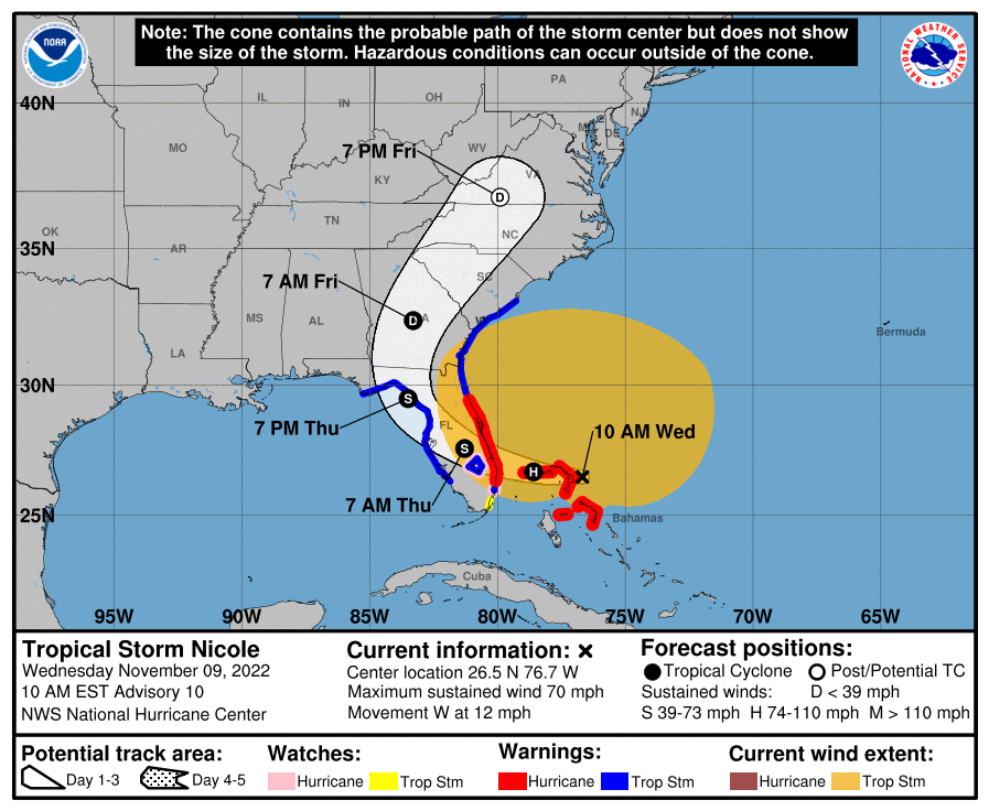
(Nation Hurricane Center) At 1000 AM EST (1500 UTC), the center of Tropical Storm Nicole was located near latitude 26.5 North, longitude 76.7 West. Nicole is moving toward the west near 12 mph (19 km/h). A turn toward the west-northwest is expected tonight, followed by a turn toward the northwest on Thursday, and north or north-northeast on Friday.
On the forecast track, the center of Nicole will move near or over the Abacos and Grand Bahama in the northwestern Bahamas today and move onshore the east coast of Florida within the hurricane warning area tonight. Nicole’s center is then expected to move across central and northern Florida into southern Georgia Thursday and Thursday night, and then across the Carolinas Friday and Friday night.
Maximum sustained winds are near 70 mph (110 km/h) with higher gusts. Some strengthening is expected today, and Nicole is forecast to become a hurricane near the northwestern Bahamas and remain a hurricane when it reaches the east coast of Florida tonight. (LINK)
Hurricane winds move in a counterclockwise direction. The winds from Nicole will initially arrive from the north. As the storm approaches landfall, areas above the eye will feel wind from the east, areas below the eye will feel wind from the east. The coastal area immediately north of the eye will feel the greatest onshore winds and threat of storm surge flooding. Everyone will experience heavy rain.
For people in Southwest Florida (SWFL) already dealing with damage, tarped roofs, debris, compromised and weakened structures, should anticipate strong winds from the north along with heavy rainfall. Securing already damaged property should proceed with this in mind. Tropical-storm-force winds extend outward up to 460 miles (740 km) especially to the north of the center.
Those Florida residents on the east coast, north of the eyewall, should anticipate strong onshore winds, storm surge and flooding. Fortunately, it appears Nicole is a fast-moving storm and impact should lessen quickly as the storm moves on shore overnight. On the downside, Nicole will be coming in after dark, which is always unnerving.
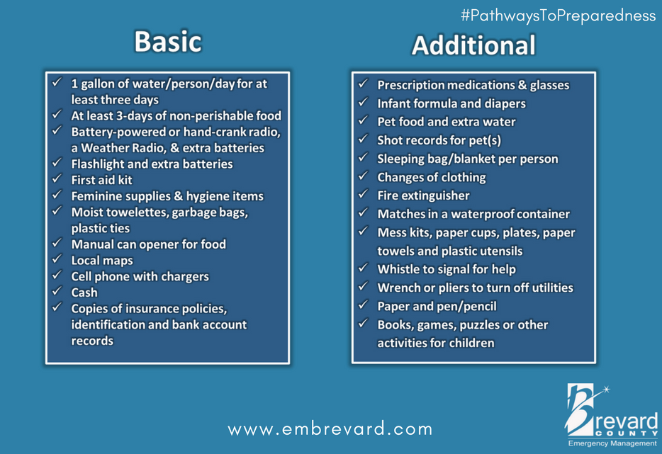
Storm Prep Suggestions Here
Thank you SD for caring and your informative post!! I keep all in my thoughts and prayers.
As do we.
Thank goodness it’s November. Dry air and shear fighting Nicole. A 9pm high tide on east coast is certainly not ideal.
Guesstimate track this morning had it right over the house when coming onshore 10 am has a few miles north again.
Should be a new update at 1 pm.
Starting to get a few fair gusts with a band of rain, it has been quite dry so far.
Waiting for Florida Plunder and Loot to lose power at any moment.
Jupiter inlet

9 am
1pm

Currently
63 mph gust
sustained 48 mph
That is not far from me….the force of Mother Nature. Time to binge watch TWC.
Where is Jim? Anyone heard from him?
Mike Slidell is currently on the beach at Vero…talking about some erosion. Its getting windy in Charleston, too.
Lived in Jupiter for a long time, moved just a few miles north to a nice RED county. LOL
If your still in FL Flicker and Flash Electric Co might not make that binge watching possible. /s
I’m totally amazed I’m not on generators already, storms 150 miles away that close enough for FP&L to have the area out already.
Just blipped as I was posting.
I’d like to see the Pumphouse
The site comes up as ‘malicious’.
Wrong inlet—Palm Beach has pump house.
This is yesterday the camera is out now…
http://video-monitoring.com/beachcams/lakeworthinlet/pics/s6/oct1622l/n080939_.jpg
Jupiter Inlet
Around 3:45 this is low tide High tide will be 9 pm.
We could get a new inlet at Peck Lake, it is where the original/ natural inlet was, fingers crossed.
Wind 50 mph with 60 gusts waves are running 22 to 25′ presently.
Eye is to be about 35 miles north (South Hutchinson Island), when it comes on shore around 4 am.
SHI is condoville populated by all of those nice understanding folks from NY & NJ bless their hearts.
This is last daylight shot from condo on south side of Jupiter Inlet.
Winds now 45 & 60 starting to get a little brisky.
Can see tide is incoming from previous post, there will be quite a bit of flooding, it is dependent to a degree to the amount of rainfall/ drainage run off.
Beach erosion is a given, the dredges head this way in winter to replenish the beaches, what you see in this shot is not even close to where the shoreline was in the 80’s, storms then uncovered shipwrecks just off shore of these pics.
Wind and rain is starting to increase, going to be one hell of a fun few days—-FJB diesel prices have made it about $11.00 per hour for generator provided electricity.
FJB–FBO–FHRC
Nice that nature is giving us a distraction….and hopefully all will be well…..while we come to the realization of what an utter sh*thole some portions of the US have become, how stupid some people are, how our elections are rigged, etc.
Does HAARP have anything to do with this?
https://haarp.gi.alaska.edu/
GeoEngineeringWatch.org
Yes, B , u know who, declared Texas and Florida
would be taken if of
This is not coincidental.
Those are the non-native/ blue locust prep lists…
Natives already keep half that stuff in their trucks.
You’re real concerns…
Propane for the grill
Handful of good cigars
Margarita mix
Tequila
Coke
Jack Daniels
Steaks
Veggies (maybe)
Chips
Salsa
No cigars. Definitely steaks, wine and chocolate muffins. Add last load of clothes washing, last load of dish washing, fill more water jugs. Wondering whether to turn off the water and/or electric ahead of the storm and when to quit reading CTH. Nicole is moving a half longitude in 3 hours just below hurricane cat 1 status. We are not forecast to receive hurricane force winds, same for Ian but he wiggled the fencing lose and I expect she will topple some of it. Made my run to pick up antibiotics, grocery, home depot for extension cords (first time with a generator) and pay RE tax. Not sure I should have done the latter…just saying.
FPL ran through my street yesterday shoring up the newly installed lines. Right now it looks like we are all doubled up but not yet working off the new set. They have been switching out the big poles for bigger poles for a year. So, I am not feeling confident about power. Although, we did not lose power for Ian, he did not land on this side of the state. Nicole might.
it’s crazy how much business total wine does right before a hurricane. ad the app zello. it’s a walkie talkie app and is awesome.
Buy ham radios… Cell phone apps are for the kiddies.
Baofeng UVR5s are too cheap not to own a half dozen.
Florida will be fine.
Far more concerned about yet another rigged election.
Thank you for the update Sundance, please stay safe.
It’s been raining here in Orlando since yesterday, looks like it will be another soaker for us, not sure where the water is going to go, it’s still high from Ian.
Thank you Sundance.
God bless you all. Praying for the safety of all in the storm’s path, and a swift recovery during the aftermath.
Thank you for the update…
Downtown St. Augustine , FL. is flooding already.
Hasn’t rained *that* much in this area yet, but downtown floods all the time when there’s rain and high tide, so…….
‘TROPICAL STORM NICOLE Headed for Florida – LIVE with David Neal / Brett Adair’
“Watch LIVE as meteorologist David Neal tracks the system and we bring you the latest
details regarding the weather situation.”:
If you’re in West Palm you should probably bring the lawn chairs in.
Please be safe, sundance – you and yours…
I think Bret Baier just said that Mar-la-go will be affected. I wonder if Trump and his family left Florida.
Think Tiffany is supposed to get married at Maralargo soon?
Saturday eve,
Praying for Florida.
Cocoa Beach…Have had high winds all day. Heavy rains just starting.
Same in NE FL.
The wind’s been great!!
palm trees swayin’!
Stay safe Sundance and Florida friends.
Prayers for all.
As always, thank you for your updates! We live on Gulf Blvd, Clearwater Beach and the hurricane is rocking and rolling. We are blessed to live here and all our storm shutter are down on our condo. We can hear the wind and through one window, which is offset into the building, we can watch the rain, wind. We can’t see the mainland, but again, we are blessed. Praying for all of Florida.