There are only two words that come to mind as I write this notice from the Ian impact zone, “mercy” and “uncle.” Prayers.
STS Nicole is anticipated to become a Cat-1 Hurricane as it approaches the southeast coast of Florida late Wednesday night. A Hurricane warning is in effect for the Northeast Bahamas, and a Hurricane Watch is in effect for the East Coast of Florida from the Volusia/Brevard County Line to Hallandale Beach. Residents along the Florida east coast should watch for updates [Hurricane Center Link].
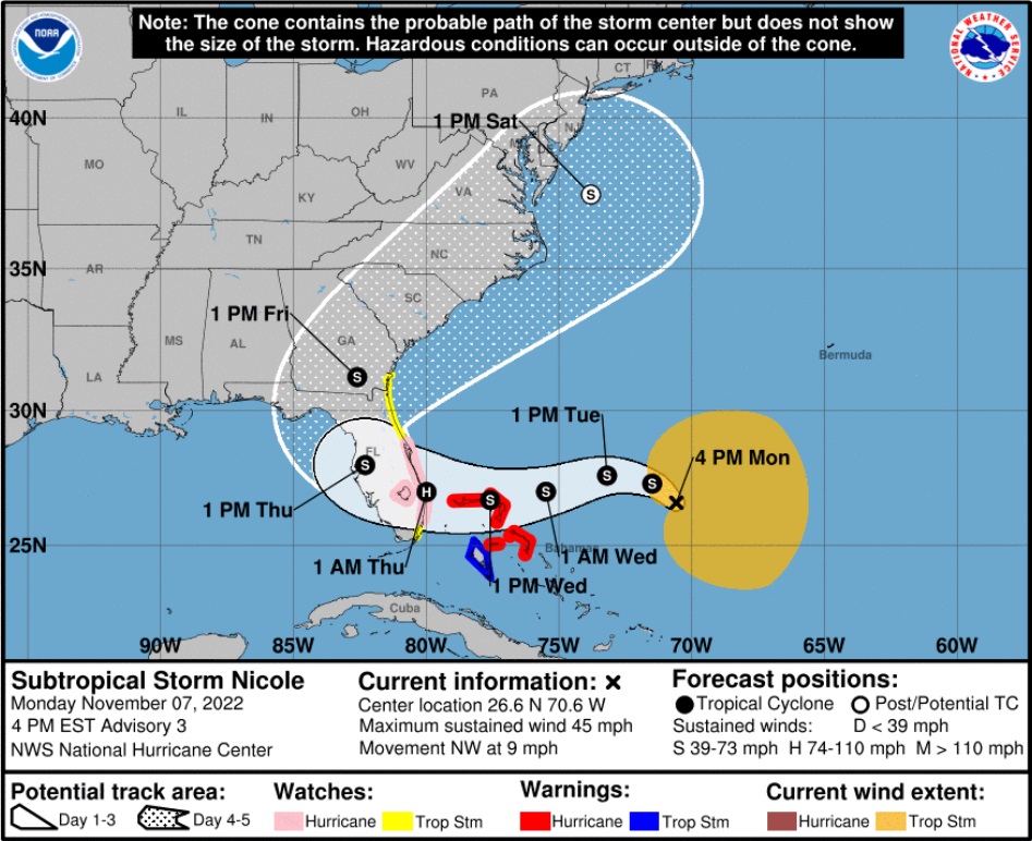
If you are on the east coast of Florida, you should begin preparations today and tomorrow for the potential of high winds, power outages, coastal storm surge and inland flooding. Georgia and South Carolina should also keep an eye on this.
Additionally, on the other side of the state, while Nicole is not anticipated to be a strong hurricane and will hopefully lose strength quickly as it moves over land, any tropical storm winds and rain along the southwest Florida areas (SWFL) previously impacted by Ian could be very troublesome. Everything is tenuously held together in SWFL and there is massive debris and structural instability present as recovery efforts continue. This is not good.
(NHC) – At 400 PM EST (2100 UTC), the center of Subtropical Storm Nicole was located near latitude 26.6 North, longitude 70.6 West. The storm is moving toward the northwest near 9 mph (15 km/h). A slower northwestward motion is expected tonight. A turn toward the west or west-southwest is forecast to begin by Tuesday night and that motion should continue through early Thursday. On the forecast track, the center of Nicole will approach the northwestern Bahamas on Tuesday and Tuesday night, move near or over those islands on Wednesday, and approach the east coast of Florida Wednesday night. (more)

There is no such thing as an “easy hurricane,” only various degrees of deadly.
All coastal residents are urged to pay close attention to local officials for evacuation orders. Each locality is different, each coastal locality has a zone of potential flooding and storm surge. As a general rule, hunker down from wind – but evacuate from water.
Right now, you are in control. Do not be alarmed – but take every preventative measure your individual situation needs. Work your hurricane plan and stay focused on what you do control. Proactive planning prevents piss-poor performance. Work the plan, step by step and focus on what is in front of you. Ignore the dark imaginings and turn off the national media. Pay attention to your local officials and local media.
Do your laundry. Sanitize and stage your water storage. Inventory your supplies. Organize your tools. Fill your freezer with water jugs to take up room and freeze. Test your generator. Stage your extension cords. Stage your battery powered devices. Test your weather radio. Take small steps to prepare. Secure your home. You are in full control.
The #1 priority is to keep calm. Keep stable. If other people around you are panicked, do not let it impact your plan. Stay focused. Stay organized. Stay in control. I cannot emphasize enough how important it is for everyone around you and your family.
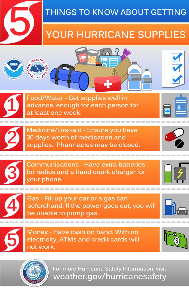
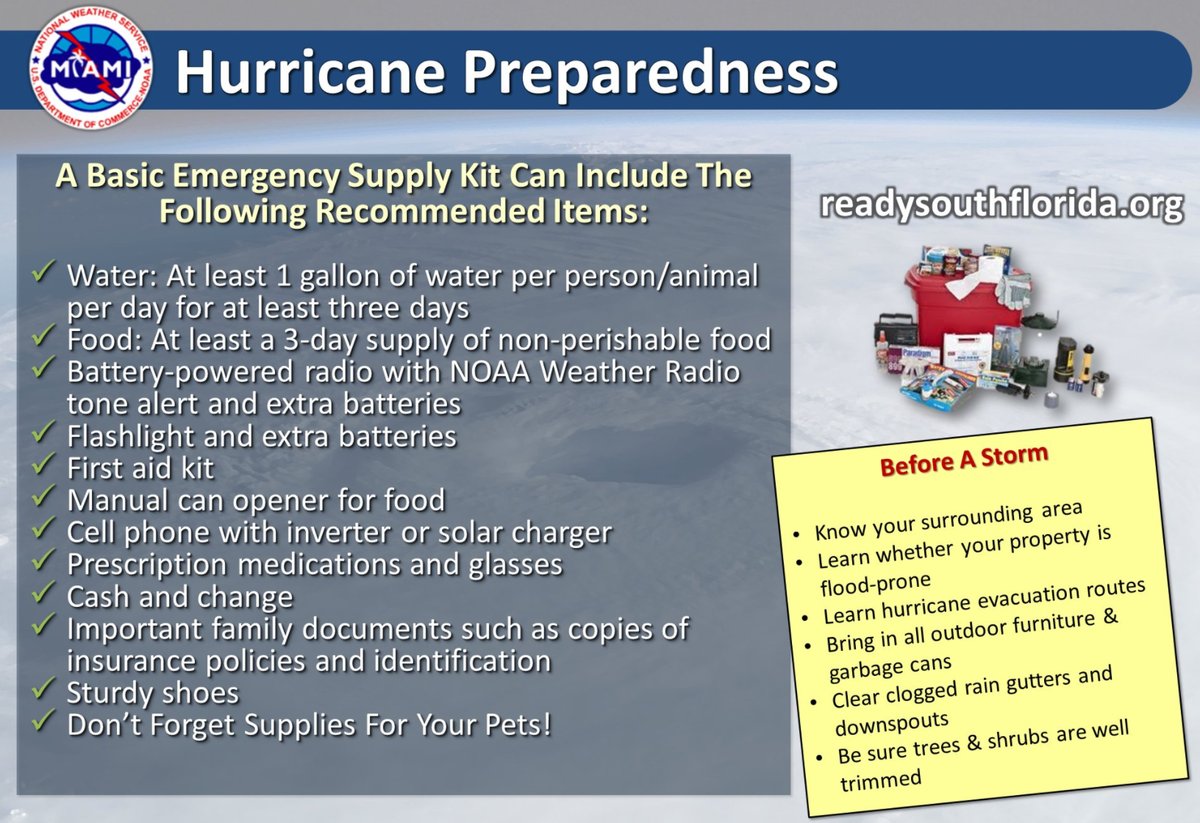
Check your hurricane supplies of shelf-stable food, water, medicine and don’t forget pets. Prepare for the worst and hope for the best. Everything is replaceable, except you and your family. We have a lot of Treepers in the path of this storm. If you need assistance, use the comments section of any ‘Update thread’ to reach out, or use the email address in the upper right of the site.
Right now, you are in control. Have a solid plan, work that plan – stay busy, and don’t get caught up in the hysteria. Try to avoid national media hype. Stay updated via your local news stations. Reach out to your neighbors; touch-base and check to see if they are okay or need anything. Community restoration begins before the storm arrives. Look out for each-other.
Regarding any evacuation plan, please pay attention to your local officials who will be coordinating with state Dept. of Transportation. As the path and impact zone of the storm becomes more predictable your local officials will alert to best route(s) for evacuation. For those in the cone of uncertainty; remember, planning and proactive measures taken now can significantly reduce stress in the days ahead.
DAY ONE (Today)
- Determine Your Risk
- Make a Written Plan
- Develop an Evacuation Plan
- Inventory hurricane/storm supplies.
- Withdraw cash based on plan/need.
- Get gas and storm supplies
DAY TWO (Tue)
- Get Storm Update
- Assemble and purchase any missing Hurricane Supplies
- Contact Insurance Company – Updates
- Secure Important Papers.
- Update/upload your phone data.
- Strengthen and Secure Your Home
- Discuss Evacuation Decision with your Family.
- Fill freezer with 3/4 full water jugs.
DAY THREE (Wed)
- Get Storm Update
- Re-Evaluate your Supplies based on storm update
- Finish last minute preparation
- Plan for a minimum of THREE DAYS without power
- Assist Your Neighbors
- If Needed – Evacuate Your Family
.
Communication is important. Update your friends and family contact list. Stay in touch with family and friends, let them know your plans. Select a single point of contact for communication from you that all others can then contact for updates if needed.
Today/tomorrow are good days to organize your important papers, insurance forms, personal papers and place them in one ‘ready-to-go’ location.
Evaluate your personal hurricane and storm supplies; update and replace anything you might have used. Assess, modify and/or update any possible evacuation plans based on your location, and/or any changes to your family status. Fill car with gasoline. Review prescriptions, refill if needed.
Check your shutters and window coverings; test your generator; re-organize and familiarize yourself with all of your supplies and hardware. Check batteries in portable tools; locate tools you might need; walk your property to consider what you may need to do based on the storm’s path. All decisions are yours. You are in control.
Consider travel plans based on roads and traffic density. Being proactive now helps to keep any future stress level low. You are in control. If you have pets, additional plans may be needed.
One possible proactive measure is to make a hotel reservation further inland that you would consider evacuating to. Follow updates of the storms’ progress; make reservations if determined; you can always cancel if not needed. It is better to have a secondary evacuation place established in advance. Being proactive reduces stress. Even if you wait until much later to cancel, it is better to pay a cancellation fee (usually one night charge) than to not have a plan on where to go. Trust me, it’s worth it. Protect your family.
If you are in the SWFL region where Hurricane Ian cleanup and recovery is still underway, just do the best you can to keep the debris in check as potential tropical storm force winds will be a major pain in the a**! Heavy sigh. ::spit::
Dear Lord, please grant mercy on the state of FL and extinguish any threat from this storm. Amen.
Amen!
Amen!
Beautiful Prayer. Amen !
NHC wasn’t providing too much info as of earlier today. At least they now have the cones up.
Swell. Possibly number 14.
I’m definitely putting up the panels this time around because it looks like the wind will get whippin’ around Lake O and the central flatlands heading to me.
Still have several of ours still up, so a little less work. It is early but right now it looks like it will catch us on the way out. We can deal with that.
Oh God no, please no, please send this storm right back out harmlessly into the ocean…
Looks like it coming in the front door, oh well here we go again.
Got almost everything done today.
Man I hate night time storms!
They still don’t know where in the cone of indecision it will be due to no real eye. We are still the bullseye if it goes as they say, it will do as it wants.
Predicting fairly quick forward movement which works to keep the strength lower with less time over the warm water. As of now it is believed to be going to travel from West End Grand Bahama to Sebring Fl. in 12 hours that’s a good sign.
If history tells us anything after 40 years in this location the FPL supplied power will go out with storm still over the Bahamas and not be repaired until it is over Newfoundland.
Lord
Amazing how these always seem to happen around election time down here
RIGHT…..I wonder who is causing this weather. I believe it’s somewhat man-made too 🙁
I do too.
I saw a Jesse Ventura program about HAARP in Alaska about 2010.
man made how?
Chemtrails and Geoengineering …..
I hope you-all make SURE they finish counting ballots tomorrow night, so none of the results get blown away. (And I hope that doesn’t come across as unfeeling from someone at high altitude. Just observing that the results of stolen Florida elections could be worse and longer-lasting than a hurricane.)
LORD, please turn this storm out to sea! And do it so clearly and definitively that You get all the credit! Amen!!
Amen!
You have come to the right people for those prayers. We offer them en masse.🙏
Praying this is just a bit of a kiss rather than a full-fledged smack on y’all. You’ve had enough for a lifetime. Good luck to all.
Hopefully its just turns out to be Red Wave.
Sundance, didn’t see your recommendation for 3 – 30 gallon trash cans for potable water???
Cracker Wisdom.
Prayers, prayers, and more prayers.
Prayers for you, Sundance, and everyone at risk.
Joe Bastardi is saying likely a Cat 2, at this time, he sees no reason why this storm won’t strengthen as it moves closer to shore.
Joe is usually spot on.
I believe he is the last great meteorologist. I refuse to get back on Twitter, but I hurriedly check out his feed. He’s the best in my opinion.
God Bless and prayers are with you…..hope it peters out before landfall….FL does not need any more misery from the weather this year
please please take your animals get them secured please!!
my best wishes and prayers to all of those in the path of this potential storm. nothing worse than being kicked in the teeth while you’re trying to get back up.
This one will expand the area of damage to areas not hit last time. Not to mention the mess it will make of the recovering areas.
Father in heaven please wrap your protective arms around the state of Florida and deflect the storms that are predicted to impact the state by turning the storms or cause them to be much less powerful.
Let the storms not cause any more damage to the state.
For You Lord God are Almighty and with You nothing is impossible.
In faith and in Jesus Christ name I pray.
Amen
The shape of this late subtropical storm is unusual. I wonder if Dane Wigginton is monitoring this the way he did with Hurricane Ian:
https://climatesciencenews.com/2022-10-05-adams-wigington-hurricane-may-have-been-weaponized.html#
The ocean is still warm which I think means it will feed the storm. Our weather has been warm the last several days (low 80ies, feels like high 80ies) keeping the water warm but weather will cool off considerably tomorrow.
The line from Friday to Saturday is pretty much going over my town but it won’t be hurricane strength and I’m prepared except for the last load of laundry and getting cash to have on hand. Honestly, I believe SC could handle this a lot better than Florida right now so if it makes a turn and comes up the coast, that’s okay. I prefer it turn out to sea but I have no power over that; it’s up to God. I pray this is not an event for Florida or anywhere else.
That’s why people should have voted early. Tomorrow they’re gonna be busy putting up panels, maybe evacuating, stocking up, etc.
I still want to know how they worked out voting in Ian Alley? How do you vote in the rubble?
Never a dull moment in the Gunshine State.
Someone convince me this isn’t weather manipulation, too coincidental…
Oh no, Florida doesn’t need another hurricane. Prepare for the worst and hope that it turns north soon!
Could the late season storm “Nicole” have significance?
The name Nicole means ““victory of the people”!
🙏🏻
There is a reason for everything. Still, being prepared is always a good thing. Sending prayers to you all.
and chicken little ran around the barnyard squawking, “The Sky is falling. The sky is falling.”
You are just kidding, aren’t you…
Philippus Aureolus Theophrastus Bombastus von Hohenheim..
..does not use cliches’..
“..I am … greater than those to whom you liken me … I can prove to you what you cannot prove … [each] little hair on my neck knows more than you and all your scribes..” –Paracelsus
for those who are interested.. below is a link from a University of Houston professor who offers a glimpse of the real Paracelsus..
https://www.uh.edu/engines/epi511.htm
For general interest, a reminder that the Hurricane Watch Net (if necessary to activate) is on amateur radio during the day at 14.325 Mhz (USB) and 7.268 MHz (LSB) at night. The amateur station at the National Weather Services Nat’l Hurricane Center (WX4NHC) also participates on the 14.325 MHz frequency as well. The 2 HWN frequencies are well established and known to marine craft as well for programming in marine-band radios as well.
Prayers for all those in the area that this thing just simply acts like a vicious slider to a right-handed hitter and heads back off into the ocean.
My motor home securely tied down near Arcadia survived the winds of Ian just fine.
All 150 mph of it.
The resultant flood a couple days later is what drowned it.
This thing looks like it is going to run up the Peace river and do exactly the same !@#$%^! thing.
All those blue tarped roofs are going to catch it.
The weakened structures also.
SMH….
Thank you Sundance!
During Ian preps, St. Lucie was recommending two weeks worth of water for each person and pet.
Gov DeSantis has declared state of emergency. This sets up the availabilty of assistance for those areas so declared:
https://www.tampabay.com/hurricane/2022/11/07/subtropical-storm-nicole-florida-governor-ron-desantis-state-of-emergency-hillsborough-county-pasco-county/
Some more “two steps at a time” incoming for some. Just exhausting.
Excellent information.
Let’s go Brandon!
I have anxiety for you. They have not yet changed the weather for us, according to the image we should get rain and they are still saying sunny and nice. Praying it will do what hurricanes do, change its mind at the last minute and this one will head out to sea. Prayers for you and all in the path.
Earlier I was thinking about the shortage on diesel, Biden needs to be charged w/crimes against humanity.
great and timely update. Thank you Sundance. I sent this article to my brother, who lives on the eastern side of central florida…literally yards from the ocean. It was received positively and he has begun the tasks you have outlined.
WE ARE ALL PRAYING AGAIN FOR FLORIDA AND GOOD OUTCOME!
God Bless America
Taking nothing away from the WISE guidance to BE PREPARED, simply to note of the latest forecast/outlook here:
https://www.nhc.noaa.gov/gtwo.php?basin=atlc&fdays=5
quote:
“The system is accelerating northeastward toward cooler waters,
while remaining in a region of strong upper-level winds.
Consequently, the chance for significant development is quickly
diminishing. Additional information on this system, including gale
warnings, can be found in High Seas Forecasts issued by the
National Weather Service.
* Formation chance through 48 hours…medium…40 percent.
* Formation chance through 5 days…medium…40 percent.”
also this: (please compare water surface temps currently to only 30 days ago…the changes are significant)
https://seatemperature.info/florida-water-temperature.html
the big eye *goes east full disk, band 8 IR (upper water vapor). <notice the steering trough! It’s quite significant.:
https://www.star.nesdis.noaa.gov/goes/fulldisk_band.php?sat=G16&band=08&length=84&dim=1
God Bless America
Time for another mandatory campout.
Florida isn’t safe, we have alligators, mosquitos, snakes, hurricanes and enough blue locust.
From what I see around Cape Coral, the blue roof tarps on most rooftops are not securely in place. Many are flapping in even a light breeze. I hope people take the time that’s left to secure the roof over their heads. I pray that there’s not another round of people’s possesions out by the street after this thing dumps 3 or 4 inches of rain on us.
https://weather.cod.edu/satrad/?parms=regional-southeast-comp_radar-96-1-100-1&checked=map&colorbar=undefined