[National Hurricane Center Link] Tropical Storm Ian has remained moving mostly westward throughout the previous 12 hours pushing the projected U.S. impact cone slightly further North into the big bend area of Florida. However, everyone on Florida’s west and gulf coast should pay close attention, and residents in Louisiana, Mississippi and the Alabama coast should not dismiss this storm.
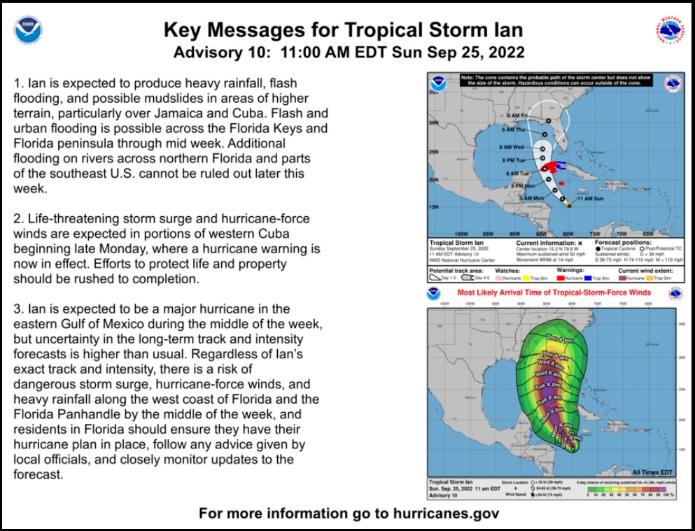
With more favorable conditions for storm development, TS Ian is now projected to intensify and be a major hurricane prior to arrival on the west coast of Cuba. That is a significant shift in the intensity forecast. However, with the westward shift, the timeline is now delayed (see map below). All U.S. gulf coast residents should be taking precautions and preparing for potential storm impacts with a path still uncertain.
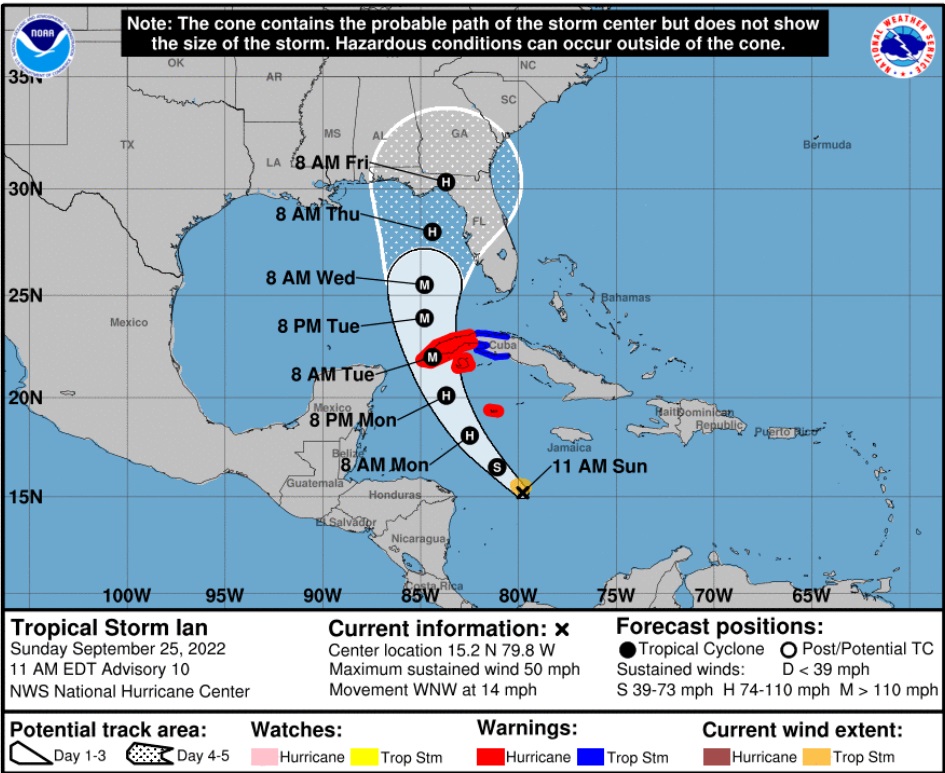
(NHC) At 1100 AM EDT (1500 UTC), the center of Tropical Storm Ian was located near latitude 15.2 North, longitude 79.8 West. Ian is moving toward the west-northwest near 14 mph (22 km/h). A turn toward the northwest at a similar forward speed is expected later today, followed by a north-northwestward motion on Monday and a northward motion on Tuesday with a slightly slower forward speed. On the forecast track, the center of Ian is forecast to pass well southwest of Jamaica today, and pass near or west of the Cayman Islands early Monday. Ian will then move near or over western Cuba Monday night and early Tuesday and emerge over the southeastern Gulf of Mexico on Tuesday. (more)
There is no cause for alarm, but with many new Florida residents’ officials are more firmly emphasizing preparation. Several FL Civilian Emergency Response Teams (CERT) are now preparing, as Florida Governor Ron DeSantis has declared a state of emergency – releasing additional responding resources. Take this storm seriously, but do not be alarmed; instead, take proactive steps to safeguard yourself and your family.
The westward storm movement has added one or two days to the projected U.S. landfall.
Proactively, do all your laundry. Bleach sanitize and air dry all your water storage containers including the bathtub, today. Do not panic if you cannot find bottled water. You can clean, sanitize and put a fresh garbage bag inside any trash can(s), then fill it/them with water from the shower. This is an old school FL cracker way to prepare for water shortages that I still do every time. Works like a charm. You can also manually flush toilets with buckets of water.
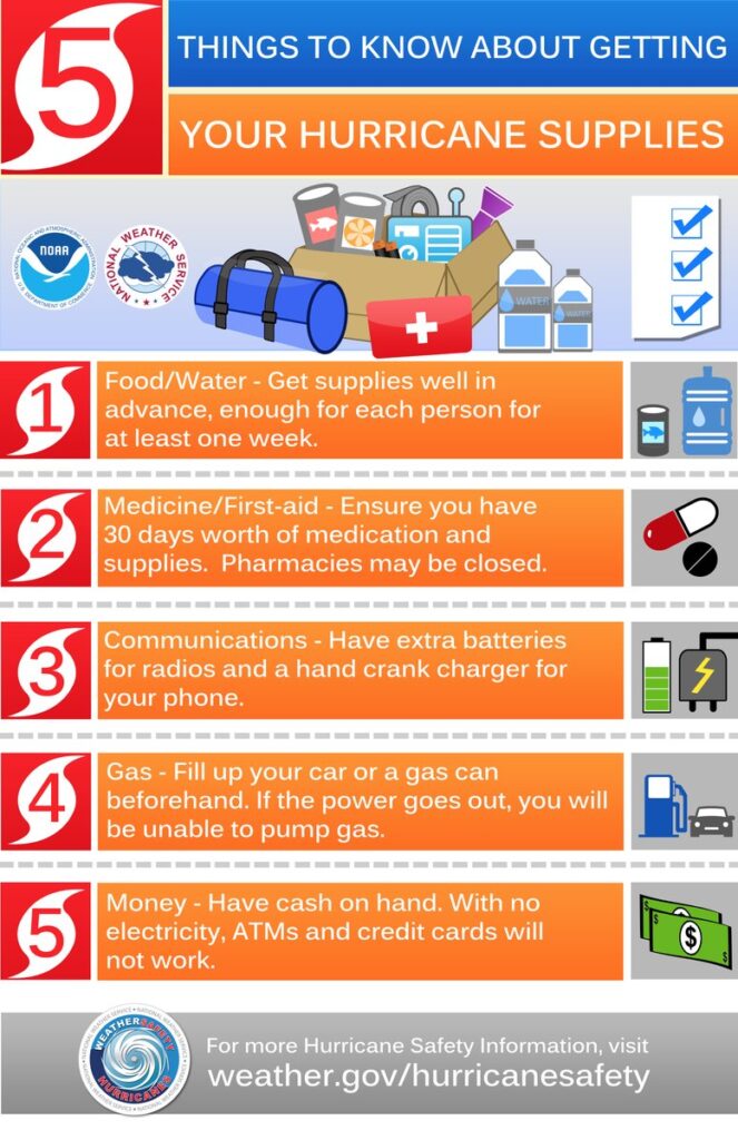
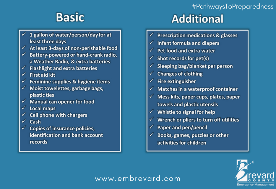
Check your hurricane supplies of shelf-stable food, water, medicine and don’t forget pets. Prepare for the worst and hope for the best. Everything is replaceable, except you and your family. We have a lot of Treepers in the path of this storm. If you need assistance, use the comments section of any ‘Update thread’ to reach out, or use the email address in the upper right of the site.
Right now, you are in control. Have a solid plan, work that plan – stay busy, and don’t get caught up in the hysteria. Try to avoid national media hype. Stay updated via your local news stations. Monday afternoon/evening looks like the key day impact zones will be identified. Reach out to your neighbors; touch-base and check to see if they are okay or need anything. Community restoration begins before the storm arrives. Look out for each-other.
Regarding any evacuation plan, please pay attention to your local officials who will be coordinating with state Dept. of Transportation. As the path and impact zone of the storm becomes more predictable your local officials will alert to best route(s) for evacuation.
For those in the cone of uncertainty; remember, planning and proactive measures taken now can significantly reduce stress in the days ahead. Plan when to make the best decision on any evacuation (if needed) consider Monday the decision time-frame. As a general rule: take cover from wind – but evacuate away from water.
DAY ONE (Sat/Sun)
- Determine Your Risk
- Make a Written Plan
- Develop an Evacuation Plan
- Inventory hurricane/storm supplies.
- Withdraw cash based on plan/need.
- Get gas and storm supplies
DAY TWO (Sun/Mon)
- Get Storm Update
- Assemble and purchase any missing Hurricane Supplies
- Contact Insurance Company – Updates
- Secure Important Papers.
- Update/upload your phone data.
- Strengthen and Secure Your Home
- Discuss Evacuation Decision with your Family.
- Fill freezer with 3/4 full water jugs.
DAY THREE (Tue/Wed)
- Get Storm Update
- Re-Evaluate your Supplies based on storm update
- Finish last minute preparation
- Plan for a minimum of THREE DAYS without power
- Assist Your Neighbors
- If Needed – Evacuate Your Family
.
Communication is important. Update your friends and family contact list. Stay in touch with family and friends, let them know your plans. Select a single point of contact for communication from you that all others can then contact for updates if needed.
Today/tomorrow are good days to organize your important papers, insurance forms, personal papers and place them in one ‘ready-to-go’ location.
Evaluate your personal hurricane and storm supplies; update and replace anything you might have used. Assess, modify and/or update any possible evacuation plans based on your location, and/or any changes to your family status. Fill car with gasoline. Review prescriptions, refill if needed.
Check your shutters and window coverings; test your generator; re-organize and familiarize yourself with all of your supplies and hardware. Check batteries in portable tools; locate tools you might need; walk your property to consider what you may need to do based on the storm’s path. All decisions are yours. You are in control.
Consider travel plans based on roads and traffic density. Being proactive now helps to keep any future stress level low. You are in control. If you have pets, additional plans may be needed.
One possible proactive measure is to make a hotel reservation further inland that you would consider evacuating to. Follow updates of the storms’ progress; make reservations if determined; you can always cancel if not needed. It is better to have a secondary evacuation place established in advance. Being proactive reduces stress. Even if you wait until much later to cancel, it is better to pay a cancellation fee (usually one night charge) than to not have a plan on where to go. Trust me, it’s worth it. Protect your family. Make the booking decision in the next 36 hrs.
♦ Look over the National Hurricane Center resources for planning assistance.
♦ Also a great resource – CREATE A PLAN
THIS is interesting:
Dated: September 6 2017 – https://www.wrightinnyack.com/blog/Understanding+Hurricane+Categories
Hurricane Categories grow exponentially …
Category 2 is 10 times stronger than Category 1
Catoegory 3 is 50 times stronger than Category 2
Caregory 4 is 250 times stronger than Category 3
Category 5 is 500 times stronger than Category 4
Category 1: Winds range from 74 to 95 mph and can be expected to produce some minor damage to property. Injuries to people and animals are generally isolated and limited to flying or falling debris. During a Category 1 storm, protected glass windows generally remain intact. Some roof damage to frame homes, apartments, and shopping centers can also occur, as well as short-term power outages due to snapped power lines and downed trees.
Category 2: Winds range from 96 to 110 mph and can be expected to produce extensive property damage. Greater wind velocities mean that debris poses a greater threat to humans and animals, while the roofing, siding, and glass windows (protected and unprotected) of frame homes are more vulnerable to damage. In a Category 2 storm, significant structural damage to apartment buildings, mobile homes, and shopping centers is also expected, as well as flooding in low-lying areas. Extensive power outages ranging from a few days to a few weeks are common, and residents are encouraged to stock up on potable water as filtration systems also fail during this time.
Category 3: Winds ranging from 111 to 130 mph cause significant damage to property, humans, and animals. Mobile and poorly constructed frame homes are often destroyed, and even well-built frame homes commonly sustain major damage. Significant damage to apartments and shopping centers (even those made of wood or steel) can be expected. Category 3 storms can also cause extensive inland flooding. Electricity and water are commonly unavailable for several days to several weeks after the storm, therefore it’s important for residents to have their own stores of canned food and water.
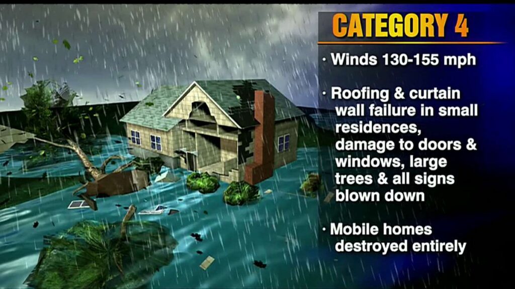
Category 4: Winds range from 131 to 155 mph and can cause catastrophic damage to property, humans, and animals. Severe structural damage to frame homes, apartments, and shopping centers should be expected. Category 4 hurricanes often include long-term power outages and water shortages lasting from a few weeks to a few months, so again, it’s important for any remaining residents to have a significant nonperishable food and water supply at hand.
Category 5: Winds at or greater than 155 mph cause catastrophic damage to property, humans, and animals (read: you should be nowhere near this storm!). Complete or almost-complete destruction of mobile homes, frame homes, apartments, and shopping centers should be expected, and nearly all trees in the area will be snapped or uprooted. Power outages can last for weeks and possibly months. Long-term water shortages should be expected as well, and most of the area will be uninhabitable for weeks or months.
Get GAS! LOTS OF GAS!
On day 3 with no power thanks to Fiona… finally seeing a few gas stations start to open, lines to the stations have main roads backed up for miles… many are waiting only to have the station run out of gas before they even make it there.
Hoping the power will be back on tonight or tomorrow but they are saying it could be out until Thursday evening, longer for those who had the wires ripped from their houses.
It appears the best outcome would be if the cold dry air coming south sucks the thermal life out of this storm quickly. Conditions for IAN will remain good until about the time it reaches the latitude of Tampa and then they become poor. Thus the NHC showing the storm weakening as it approaches shore.
Yep, the Jet Stream stears these storms, so take a look at it now and it’s projected position tomorrow through Friday.
I agree, and hope the cold front will knock it down in strength and will probably steer Ian into the West Coast of FL from Ocala/Tampa, Southward.
Be Prepared, not Scared.
Storm Prep biggie: Photograph the interior and exterior of your residence, including all high $ valuables to be used later in your hurricane property damage claim with an insurance company or FEMA.
As a FEMA Disaster contractor evaluating storm damaged homes for six months after H. Katrina in the surrounding five Parishes of NOLA, in S.E. Louisiana, I found that the photos of pre-strom homes really helped me in submitting accurate damage reports, which meant higher payouts to home owners.
After the six months, I worked as a paralegal for a best friend attorney in his New Orleans law firm and successfully gained 90% of all the claims we made for over 300 home owner clients at the Hurricane Mediation program set up by LA Insurance Commissioner, Jim Donelon.
We didn’t have to go to Civil District Court to pursue a law suit against insurance companies Once,… and our clients got their $ at Mediation or a couple of weeks thereafter.
(Then came the Fight with the Mortgage Companies who didn’t want to give up the insurance check $ – earning interest on it was a priority to them, but, again we prevailed via legal means)
The pics really help substantiate the claim and that is how you earn your recovery $.
The FEMA house or apartment damage report is also of great significance, so help FEMA inspect your residence,.. it only takes 30 minutes, by FEMA rules, so file your claim with FEMA asap by phone or CPU and you will be given an appointment with a trained contractor like me. (no, it won’t be me,…. I haven’t done this work since Katrina. At that time, I lived in and worked out of the upstairs of my flooded Metairie, LA (NOLA subburb) home for 6 months while I did this work only cuz my employer left the state one week after Katrina and I had a mortgage to pay).
Having lived through and survived Hurricanes Camille (Pascagoula,’69, Cat 5, – worst ever with winds clocked at 239 mph, 30 miles SW of Pascagoula, MS on a Merchant ship riding it out in the Gulf whose wind odometer exploded at that #), Frederick ( Gautier,’79), Alicia (Houston, ’83), Elana (Gautier’85) George (Biloxi, ’98), Katrina (NOLA, ’05, Cat 3), and several in NOLA and the MS Gulf Coast since,… Sundance’s advice is highly valuable to your well being, post a hurricane land fall in your area.
Take heed and Bon Chance with Ian.
Super interesting. What ever happened to Chris Rose/ Times Picayune.
Last I heard of Rose was on WRBH FM radio in NOLA, the “Lighthouse for the Blind” station. He would read his articles from the TP, and that was a couple of years ago. He would come on-air before the Green Wave football games that the station would carry that I would tune into, so, that’s how I heard his Liberal world views. He does have his interesting, engaging style, though.
I worked for the TP many years ago, before it became the rag it is now.
Getting bought out by the Advocate probably saved it from extinction. My Dad was living in West Jeff during Katrina and got flooded. Correct about difficulty in getting insurance money out of the mortgage servicer to pay for work done. Had some in-laws got wiped out in Golden Meadow by Ida. Problem with hurricane is there is mostly plenty of time to hype it, but track change of 20 miles makes all the difference.
Yes indeed, Hurricane Ida’s track change to the East chased us out of our Slidell home to Gautier, MS, a day before it hit,…where we stayed safely for two weeks with family.
My Slidell house was not damaged except for downed back fences, a 40′ long broken limb ‘widow-maker’ hanger in our 110′ pine next to the pool, which was dark green and ready to be a bass pound when we returned.
I gave my house portable gas generator to my elderly neighbors with 30 gals of gas, and got out, cuz I knew the power would be out for a couple of weeks or more, with no food stores or gas stations open.
All part of living on the Gulf Coast.
But, remember, hurricanes keep the South East USA green with all the rainfall they pour on our Pine and Hardwood tress,… and those eat CO2 and give us Oxygen to breath,… SO, remind the Marxist Climate Change, Green Energy freak Hoaxers,… it’s Nature’s way, not their’s.