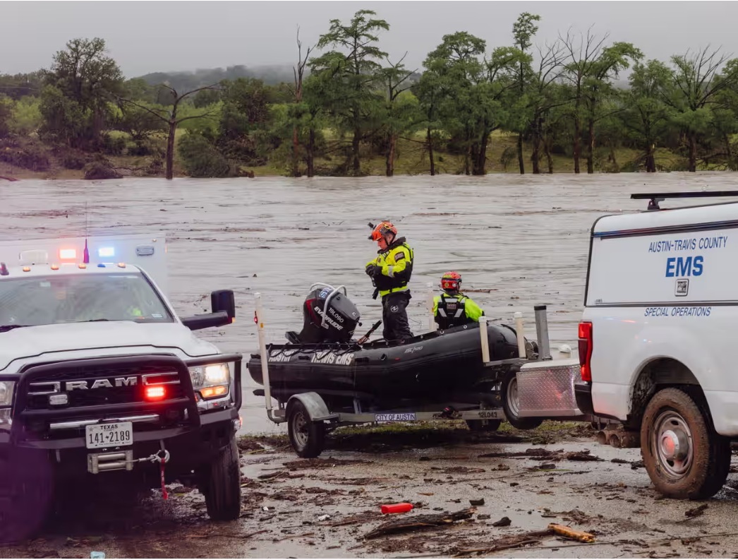
A painful update from Kerr County officials in Texas. The death toll has risen to 27, with 18 adults and 9 children killed. UPDATE: 32 killed. 18 adults and 14 children.
The region was beset by death and disaster on Friday after months’ worth of heavy rain fell in a matter of hours, leaving search teams to conduct boat and helicopter rescues in the fast-moving water that overtook riverfront communities and children’s summer camps.
The US National Weather Service declared a flash flood emergency for parts of Kerr county, located in south-central Texas Hill Country, following the heavy downpours. Officials in Kerrville, Texas deliver an update press conference.
UPDATE 3:00pm CT – Officials in Texas called the severe flooding a “mass casualty event” and said between 23 and 25 people were still missing from a summer camp. Texas Gov. Greg Abbott, Department of Homeland Security Secretary Kristi Noem and other authorities provided an update.
.
10:00am CT
A Kerrville city official said during this morning’s press conference that there will be two more briefings today, to update the public about the flood and rescue efforts. The next press briefing will be at 2pm Central time and the following will be at 6pm Central time.
Authorities say more than 1,000 rescuers are on the ground in Texas, searching for missing people as rains continue to fall outside of San Antonio, the Associated Press reports. Flash flood warnings remain in effect.
Twenty-seven girls from Camp Mystic remain missing, officials say, as authorities have rescued more than 850 people during operations so far.
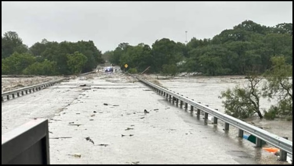
The destructive fast-moving waters along the Guadalupe River rose 26 feet in just 45 minutes before dawn Friday, washing away homes and vehicles. The danger is not over as torrential rains continue pounding communities outside San Antonio and flash flood warnings and watches remain in effect for parts of central Texas.
MTG Introduces Bill Prohibiting ‘Weather Modification’: ‘Will Be a Felony Offense’…
Rep. Marjorie Taylor Greene (R-GA) revealed that she was introducing a bill to prohibit the use of “weather modification” or geoengineering to change weather conditions, temperature, or sunlight intensity.
In a post on X, Greene explained that she had been “researching weather modification” and had been working with the legislative counsel for several months regarding the bill. Greene continued to express that no person, company, or government should be able to “modify our weather by any means possible.”
“I am introducing a bill that prohibits the injection, release, or dispersion of chemicals or substances into the atmosphere for the express purpose of altering weather, temperature, climate, or sunlight intensity,” Greene wrote. “It will be a felony offense.”
Greene added: “I have been researching weather modification and working with the legislative counsel for months writing this bill. It will be similar to Florida’s Senate Bill 56. We must end the dangerous and deadly practice of weather modification and geoengineering.”
Nimrodman thank you for posting this! Florida and Tennessee have outlawed chemtrails and weather modification. Weather can be used as a weapon.
Did you see this?
Monster Rip Current California coast.
https://www.thegatewaypundit.com/2025/07/socal-hundreds-rescued-monster-rip-current-newport-beach/
And in Nevada:
https://www.fox5vegas.com/2025/07/01/dust-storms-downed-power-lines-part-wild-weather-day-las-vegas/
GeoEngineeringWatch.org has lots of research and many articles and podcasts on WEATHER WEAPONIZATION (or “modification”).
HOW does one enforce the laws in FL and TN?
Here in FL (and I’ve heard also in TN) we still see Chemtrails 5 or more days a week!!
I am not sure exactly how it will be enforced. I read and watch as much as I can. What was presented about enforcement was the State can regulate up to 2,000 feet. Federally can be regulated beyond 2,000 feet.
I know that RFK Jr. has dedicated some resources and that Americans all across the USA are sending pictures, and those pictures provide information on the date, time, location, and sometimes tail numbers. The research (which may lead to DARPA) is then assembled via the FAA records etc. That is at the state level. It is the chemtrail that leaves the proof for prosecution.
At the federal level there will have to be investigations at the jet fuel level, residue on the planes, interviewing commerical airlines and pilot/ground crews when they land. The military can assist with the higher flying jets. Since England has reported that they are involved in this weather weaponization probably will require the Trump Admin. to sanction these countries when their manipulation of International flights comes into our air space or their “modification” spills into the USA.
We have satelites and drones which can provide more information. Also, NOAA has personnel and equipment that can be dedicated to ending this poison. NOAA may have first hand knowledge…..
Congress passed an Act:
The National Weather Modification Policy Act of 1976 (P.L. 94-490), reproduced as appendix A to this report (the “Act”), directed the Secretary of Commerce to conduct a comprehensive study of the status of weather modification science and technology and to submit to the President and the Congress a report on the findings, conclusions, and recommendations of the study. This is the report prepared pursuant to that Congressional directive.
https://www.congress.gov/94/statute/STATUTE-90/STATUTE-90-Pg2359.pdf
So they know. It is not a “secret”. That is the lie.
Al Gore, Bill Gates and many other Globalist hacks need to be investigated individually for their participation in this as part of the MAHA investigation. These weather weaponization chemicals cause health problems, and harm soil, water, plants and animals as well
AFAIK Florida Gov Ron DeSantis does NOT have a means to send enforcement planes up in the sky to follow these manned or unmanned aircraft back to their airport and arrest them.
And the deep state FEDS do NOT want to stop the spraying of these poisons.
GeoEngineeringWatch.org has held FREE annual info events at which an ex-CIA agent spoke one year. Sherry Tenpenny has spoken there, too. Many experts.
There’s a very interesting discussion on YT between RFK Jr and Dane Wigington of GeoEngineeringWatch.org that took place in 2024 I believe.
If the geo-engineering planes are taking off, landing in FL, I would think that although the states can’t regulate over 2000ft as someone mentioned, that states could take away business licenses to operate, deny entry beyond federal facilities, prosecute based on evidence in the atmosphere below 2000ft, etc. States like FL got creative when Biden was bringing in illegals, for example, and went after businesses who transported or provided services to them once on state soil.
The best solution is an EO from Trump or Congressional laws passed to make this practice illegal. Otherwise planes will use states that have lax laws as their base of operations.
They are flying MUCH higher than 2000 feet so states would have no basis to take away pilots’ licenses.
As Dane Wigington of GeoEngineeringWatch.org has taught us from his meticulous research for many years, those in charge of the spraying want to get those chemtrails as HIGH as possible so that the chemicals take longer to float down to land.
FL and TN are NOT enforcing this in any manner that I know of.
I’m sure the Deep State feds do NOT want to enforce an EO from PDJT or any law MTG or others pass.
thx, Donna
that rip current was generated by large surf, either from a mid-latitude low pressure system down by New Zealand or the tropical storms off Mexico last week … no climate modification needed as explanation
just going to read about the dust storms now
alright, read about the dust storms … article cited winds up to 60 mph
sounds to me like a cold front / frontal band pushed thru the area with high winds
that’s common, doesn’t merit weather modification explanations
if associated with mountains, there’s also the phenomenon of chinook winds on the downwind side
again, normal meterology
Thank you 🙂
Rainmaker Technology Corporation has precipitation enhancement documents filed with NOAA that indicate they would be seeding clouds West and Southeast of Kerr County TX . This is available on the NOAA website. Not a public traded corporation. No board of directors or investors listed. Registered in Wilmington DE
yes, FloridaPatriot posted a link to them in his comment on page 1
https://theconservativetreehouse.com/blog/2025/07/05/death-toll-rises-from-catastrophic-texas-floods-along-guadalupe-river/comment-page-1/#comment-11919336
Every decade or so there seems to be a tragedy involving flash floods at night and campgrounds.
Perhaps it would be a good idea for camp owners to install emergency platforms that campers could get above the flood until help arrives or the water subsides.
A platform would be good, but how do you build one that would work against this?
“…the Guadalupe River rose 26 feet in just 45 minutes…”
26 feet of water. 26 feet. That there is crazy.
Crazy, yes.
https://water.noaa.gov/gauges/08166200
Steel beams driven into ground with pile driver or encased in concrete.
With a ladder & platform on top.
You could cover with old wood to camouflage and look like a tree fort.
You do realize just one of the approx. 20 campgrounds along the Guadalupe had 750 girls? The platform would need to be the size of some medium-sized high school football stadiums for one-two camps.
Thank you for working on this problem! Let’s keep working on solutions!
Anybody?
Some people are trying to think of a way to prevent the flood deaths in the future. Good for them!
One small city on the Guadalupe solved part of their problem in a specific area – permanently!
But, it would be VERY UNPOPULAR and EXPENSIVE For campgrounds!!!
There was a long-time neighborhood built near the Guadalupe in the city limits. The more expensive homes had large lots and were located next to the river.
Well, every time the city experienced a flood, those houses would flood badly. Not sure, but I’m thinking some entity (FEMA?) would pay the owners for the damages, and they would repair and rebuild.
After the city had two more massive floods in four years, with the owners of at least one-two of the homes hanging from trees over two stories above the floodwaters, the entity said, “Enough is enough!”
Don’t recall exactly how they went about it, but I think they re-zoned the properties that always flooded, and would NOT let the owners or anyone else rebuild there!
The city turned the riverbank lots into a public park with a gentle grassy slope down to the river, where people could picnic, play in the water etc.
Now, I can’t recall WHAT ENTITY (FEMA?) paid the owners for their homes and lots, but it put a stop to the same flood claims over and over!
The corps of engineers has 50 year frequency and 100 year frequency maps of flood zones showing the width ( or elevation on contour maps) of floodwaters along rivers and streams – for the nation.
If / when someone wants to construct a building within a flood zone then a permit is required – that may need special design to be above ( on stilts ) or built sturdy enough to handle the infrequent flooding.
( but the building might not be covered by home owner insurance or be able to get fema funds to repair damages or rebuild – after a flood ).
A lot of drainage and bridge structures with an understanding that structure be able to convey the floodwaters, or be built above the floodwaters elevation ( per flood maps ).
Sometimes the floodmaps get updated – based on storm frequency / intensity and flood history.
Note that several bridges were constructed high enough. ( if the floodwaters did not
overtop the bridge )
But a lot of scouring at the base of the bridge pier footings may need inspecting ( and maybe repair )- after the flood waters subside.
A rotating / circular weather system ( caused by a stationary weather front )
can sometimes cause repeated sunshine or precipitation in some locations across the globe.
Sometimes that takes another strong weather front to nudge the stationary front downwind ( often easterly )
Imho
https://www.fema.gov/about/organization/region-6/base-level-engineering-ble-tools-and-resources
This on-line tool can be used to check your home address to see if it is located within the 100-year or 500-year frequency flood zone.
It shows depth and width (extent) of both flood frequencies.
It covers much of the populated portions of Texas.
this clip shows bridges being swamped / destroyed
July 4, 2025 The Guadalupe River Has Risen 26 Feet In 45 Minutes In Comfort, Texas #flood
Multiple small platforms.
Floods in a waterway are a function of rainfall in the watershed. We knew it was raining in the Guadalupe watershed, but, AFAIK, did not report it. Or, at least, did not report it to the right people. This has been a problem for many years.
Grew up in the area and my In-laws lived in Hunt, TX for 25 years…one of the most beautiful spots in the entire Great State of Texas. Our family lived on the Guadalupe River outside of Kerrville and got 3’ of water in the house in the flood of 1978.
A friend that still lives in Hunt told me the UGRA (Upper Guadalupe River Authority) lost transmission with the water level transmitter just upriver from the camp at 29’.
I’ve been to Camp Mystic several times back in the late 80’s and have driven by the camp over 100 times in the past 25 years as I work in the Hunt, TX real estate market.
Lots of politicians daughters have attended the camp over its almost 100 years in operation (Laura Bush attended the camp and was also a camp counselor as a youth apparently). Glen Youngkin’s (gov of Virginia) owns land in the area and his wife also attended the camp).
After seeing video and photos sent to me by some local friends living in Hunt, the water levels appear to have been at least 35-40’based on debris level/water marks, in a very tight canyon nonetheless, with an additional creek flowing through the camp, emptying into the Guadalupe right in the middle of the camp..
Our best guess would be that the river rose anywhere from 30-50’ in 45 MINUTES, which would make it unprecedented.
From what I’ve seen and read, the emergency plan for the camp was solid based on the highest previous flood level of 36’ set back in 1938 I believe. Apparently all the campers in the lower areas closer to the river were moved up the hill to higher grounds and buildings that night. The cabins that were at or near the highest recorded flood mark were left in place and would be the last to evacuate if needed.
These cabins were also the cabins where the youngest campers were staying.
Once Dick Eastland, the longtime owner and camp director realized that the water was rising so fast and that those cabins were going to be overtaken by the flood waters, he drove his truck into the water to try and rescue the girls. Search and Rescue unfortunately found his body today. I can’t think of those 27 little girls, it rattles my soul a bit.
The last thing my friend said today on the phone was “Hunt is gone.” Absolutely devastating. Our hearts are broken for all of the people and kids lost in this tragedy. Many many prayers are needed.
Dick Eastland will be remembered for his brave attempts to save as many young campers as he could.
A true man of Christ.
May all who perished in this tragic flood event find everlasting peace in the arms of our dear Lord Jesus Christ.
install emergency platforms that campers could get above the flood until help arrives
just evacuate on foot to higher ground … take blue tarps and string them among the bushes for bivouac shelters to wait out the flood … blue tarps and rope/cord can be provided at the camp cabins
most flyover aerial news coverage shows sloping land down to the river floodplain where camps are situated because it’s flatter land. but all the flyover I’ve seen has higher ground adjacent that could be climbed on foot to get up and out of flood’s reach
and having written that, I see in Tejas Dave’s comment above that just such a strategy of ‘evacuating uphill’ was planned and underway, the strategy being to move to the highest-elevation cabins of the complex
thanks for the factual reporting from first-hand sources, Dave
Absolutely definitely not climate change.
Thank you for posting TM.
💔 💔 Heartbreaking 💔💔
🙏 🙏
“165 victims saved in the Texas floods by Coast Guard Rescue Swimmer Scott Ruskin.”
Cont…
God Bless each and every one that helps.
People have those gifts and they are God-given.
We in western NC saw the very same reaction and ‘army’ descend post-Helene..
We can never thank or appreciate the rescuers enough, however, they don’t do it for praise or adoration.
I can’t stop thinking of the little girls…
I know. It’s devastating to think of the trauma and the massive fear they endured.
WE PROTECT our children. It’s a natural instinct and when we can’t…we can’t comprehend….
Weird. Bothers the heck out of me. There was a movie call Sweet Hereafter that comes to mind. Tore me up like this.
The Canadian director Atom Egoyan adapted the screenplay after his wife, the actress Arsinée Khanjian, suggested he read Russell Banks’ The Sweet Hereafter.[4] The novel is inspired by an incident in Alton, Texas, in 1989, in which a bus crash killed 21 students.
A school bus crash occurring on September 21, 1989, in Alton, Texas, in the Rio Grande Valley region, resulted in the deaths of 21 junior and senior high school students by drowning or causes related to being asphyxiated. A bottling truck collided with the school bus, causing the bus to enter a caliche pit filled with water. The driver of the truck was acquitted of negligent homicide charges. The payoffs from lawsuits compensating for the deaths of the students caused division in the Alton community. A local middle school was subsequently named in honor of the deceased.
This tragic hurts so bad and it is not even my kids.
For the people in Texas the song from the movie tells it all.
Watch the band through a bunch of dancers
Quickly, follow the unknown
With something more familiar
Quickly, something familiar
… Courage, my word
It didn’t come, it doesn’t matter
… Sleepwalk, so fast asleep
In a motel that has the lay of home
And piss on all of your background
And piss on all your surroundings
… Courage, my word
It didn’t come, it doesn’t matter
Courage, your word
It didn’t come, it doesn’t matter
Courage, my word
It didn’t come, it doesn’t matter
Courage, it couldn’t come at a worse time
… There’s no simple
Explanation
For anything important
Any of us do
And, yeah, the human
Tragedy
Consists in
The necessity
Of living with
The consequences
Under pressure
Under pressure
… Courage, my word
It didn’t come, it doesn’t matter
Courage, your word
It didn’t come, it doesn’t matter
Courage, my word
It didn’t come, it doesn’t matter
Courage, it couldn’t come at a worse time
… It couldn’t come at a worse time
No
It couldn’t come at a worse time
… Courage
I just can’t watch the coverage. It is too heartbreaking. I can’t remember the last time such an event affected me like this. Praying for the families and hoping for rescues to come.
MOST difficult to predict.
Last fall, it was not predicated or expected for Hellene to destroy NC mountains, east Tn, SW Va.
SAME results.
It’s a TRAGEDY and we simply pray for those families…..we pray and pray.
It’s NOT anyone’s fault. We in NC didn’t blame Biden, et als for Hellene….we prayed for the families and we got our butts in action TO HELP.
If one LISTENS to Dane Wigington at GeoEngineeringWatch.org one would hear the predictions — for YEARS now.
That is the truth, Jwmson.
Texas has always had unpredictable and intense weather.
Cloudseeding Company “Rainmaker” Founded By 25 Year Old Thiel Fellow Augustus Doricko, Was Seeding In Texas Flood Areas 2 Days Before Flood: “Stewarding The Natural World.”
https://celiafarber.substack.com/p/cloudseeding-company-rainmaker-founded?publication_id=257742&post_id=167633761&isFreemail=true&r=hevwr&triedRedirect=true&utm_source=substack&utm_medium=email
It surely seems a company could not do this without a license, or permit, or knowledge of “those in authority.” Who has “authority” in Texas? Why did the governor mobilize 14 relief agencies on July 2 on a “pro-active” basis? Not asking for a friend. Asking on behalf of dear ones who live in Texas.
First of all, they weren’t RELIEF AGENCIES. They were EMERGENCY RESPONSE AGENCIES, etc.
Second, the word, MOBILIZE wasn’t used. The report said, ACTIVATED.
To me, MOBILIZE means to GET MOVING, TO BE PRESENT SOMEPLACE, while ACTIVATE means BE PREPARED TO MOBILIZE. (Maybe as in: don’t take days off or begin a vacation…)
Perhaps there is a difference in what those mean as applies to a state agency’s employees. I would not know that.
A family member told me that, early on, a reporter had been very negative to Governor Abbott as to why he had ACTIVATED all those groups when no known emergency existed.
Governor Abbott replied that if you wait until a emergency EXISTS, you have waited too late!
🤨
“My name is Augustus Doricko. I’m the CEO and founder of Rainmaker. We’re a cloud seeding company that is enhancing precipitation via advanced radar and also drones.” (Video)
https://x.com/HustleBitch_/status/1941577060889264303
“The US National Weather Service declared a flash flood emergency”. Yeah, sure they did, but WHEN?
Prior to flooding on the Ohio this spring, one restaurant on the river, which was steel, concrete and glass construction, emptied out all of the furniture and disconnected all the electric. They sealed it up, and filled it with fresh water before the flood waters reached them.
Their reasoning: easier cleanup. A photo from the inside of the restaurant at the height of the flood was striking. Clean water inside, and dark muddy river water on the other side of the windows.
37 minute video, during daylight, of the flooding in Center Point,TX (10 miles from Kerrville). Watch this, then imagine being near the river in the middle of the night. This event was an inland tsunami.
No talking, so you can run it at 1.5-2x speed.
The river water & debris is taking out 30-40 year old live trees upstream from bridge.
Eventually overtops bridge in the middle and at the end, a house comes floating down and lodges against bridge.
Water rise is 25-35 feet beginning to end at the bridge. Hard to tell exactly, but it was a LOT.
“He causes his sun to rise on the evil and the good, and sends rain on the righteous and the unrighteous.”
When Hunga Tonga Met Texas
The Texas Hill Country flood may have packed a bigger punch from the Hunga Tonga volcanic eruption of 2022.
John Leake
Jul 06, 2025
“….As has become the norm in recent years, much of the media has rushed to characterize the flood as having been accentuated or even caused by human-induced climate change.
More likely the flood was accentuated by the Hunga Tonga-Hunga Ha’apai volcano that erupted in January 2022 and injected into the atmosphere an estimated 150 million tons, or roughly 10% of the pre-existing water vapor in that atmospheric layer.
Meteorologists and atmospheric chemists have noted the following about the eruption.
*Unprecedented amount of water vapor:
The eruption injected an unprecedented amount of water vapor into the stratosphere, a layer of the atmosphere between 15 and 40 kilometers above the surface….”
https://open.substack.com/pub/petermcculloughmd/p/when-hunga-tonga-met-texas
Trump Signs Disaster Declaration for Texas Floods
author
The Frank Staff
3 hours ago
3 min read
https://www.thefrank.com/article/trump-signs-disaster-declaration-for-texas-floods
Socialism to the resuce!
Death toll is now at 68.
https://www.kens5.com/article/news/local/texas/texas-floods-kerr-county-searches-death-toll-missing/273-11d17a3a-1e0e-4fbc-82bf-dcc0bff5c664
Sunday afternoon, When is President Trump going there?
The stories coming out are beyond heartbreaking.
He should go
He said probably Friday. He said he did not want to get in the way of the rescue.
And that is very wise. They were advising anyone not actively involved NOT TO SHOW UP!
Mind-Blowing Time Lapse Video Shows How Quickly Flooding Happened in Texas
https://www.thegatewaypundit.com/2025/07/mind-blowing-time-lapse-video-shows-how-quickly
Death toll continues to rise.
https://www.thegatewaypundit.com/2025/07/texas-flood-death-toll-reaches-79-expected-continue/
For those still interested: A few minutes ago, I was informed that New Braunfels, Texas (a city of about 100,000, home of Schlitterbahn Water Park, located between Austin and San Antonio), received a red level “EMERGENCY FLASH FLOOD WARNING (This is a dangerous and life-threatening situation. Do not attempt to travel unless you are fleeing an area subject to flooding or under an Evacuation Order.”
New Braunfels had 100 Year Floods in 1998 AND 2002! It is in the Guinness Book of Records for having 2 rivers within the City Limits. The smaller, spring-fed Comal River, which feeds into the mighty Guadalupe River. Many 1,000’s flock to New Braunfels for summer recreation and from all over the world to attend the annual Wurstfest celebration.
NOW, here’s the National Weather Service forecast for tonight in New Braunfels: 30 % chance of showers then mostly cloudy with an addition for the red level Flash Flood Warning.
There are actually 3 levels of Flash Flood notifications listed:
Flood Watch
white
Flood Advisory
yellow
Flash Flood Warning
red
They were issued in that order.
But the Forecast was as above.
DHS says mainstream media is ‘deliberately lying’ about events leading up to Texas flooding
Homeland Security
@DHSgov
The mainstream media is deliberately lying about the events leading up to the catastrophic flooding in Texas.
The National Weather Service executed timely, precise forecasting and warnings, despite unprecedented rainfall overwhelming the region.
Here is the timeline of NWS’s proactive response:
Chris Martz
@ChrisMartzWX
·
8h
So, let’s discuss the flooding in Texas.
Here are the facts many Democratic mouthpieces and some legacy media outlets are choosing to ignore:
https://abs-0.twimg.com/emoji/v2/svg/31-20e3.svg The National Weather Service (NWS) office in Austin / San Antonio was staffed with five meteorologists throughout the storms on Thursday and Friday, according to NWS meteorologist Jason Runyen. Most offices usually have two on staff when the weather is benign.
https://abs-0.twimg.com/emoji/v2/svg/1f517.svghttps://apnews.com/article/texas-floods-hill-country-weather-warnings-238d4325bb58f0b410015f74684738b6
So, the claim that the 11% reduction in NWS employee headcount from the Trump administration’s RIFs played no role in their ability to post forecasts and get information out to the public is WRONG.
https://abs-0.twimg.com/emoji/v2/svg/32-20e3.svg The NWS office issued a flood watch for the area at 1:18 p.m. CDT on Thursday, more than 15 HOURS in advance, urging residents to be weather-aware.
At 1:14 a.m. CDT, they issued a flash flood warning for, more than three hours before the Guadalupe River rapidly crested at 29.45 feet in Hunt, which is located near Camp Mystic.
https://abs-0.twimg.com/emoji/v2/svg/1f517.svghttps://mesonet.agron.iastate.edu/wx/afos/p.php?pil=FFAEWX&e=202507031818
https://abs-0.twimg.com/emoji/v2/svg/1f517.svghttps://mesonet.agron.iastate.edu/wx/afos/p.php?pil=FFWEWX&e=202507040614
There was plenty of warning from forecasters, even if initial forecasts did not predict some 12-20 inches of rain falling. The unfortunate aspect of all of this is that most people were probably asleep when the waters rose, and with no county flood warning systems that function like a tornado siren, the flash flood warnings posted by the NWS went unnoticed.
https://abs-0.twimg.com/emoji/v2/svg/33-20e3.svg The flooding was inevitable.
The remnants of Tropical Storm Barry, which made landfall in Mexico, were absorbed into a broad, retrograding upper-level low. Further destabilization of the lower atmosphere resulted in a rotating mesoscale convective vortex (MCV), which stalled over Central Texas and dropped over 1.8 trillion gallons of rain on the Hill Country. https://abs-0.twimg.com/emoji/v2/svg/1f327.svg
The dynamics involved here are poorly understood, and as a result, mesoscale models have a very difficult time predicting exactly where these sorts of systems will form and exactly how much rain could fall.
What’s more, the terrain across the Texas Hill Country is characterized by a dry, thin layer of topsoil and exposed rocks on the surface, making it prone to flash flooding events. Heavy rainfall isn’t readily absorbed, and trickles down into nearby rivers and creeks, where it causes them to spill over their banks. https://abs-0.twimg.com/emoji/v2/svg/1faa8.svg
https://abs-0.twimg.com/emoji/v2/svg/34-20e3.svg The rainfall and flooding were not unprecedented, and it had little to do with climate change.
Camp Mystic and neighboring communities like Hunt and Kerrville are located on the floodplains of the Guadalupe River Valley. The sediment that they’re built on has been deposited by hundreds of floods over the last several thousand years.
Flooding there is expected.
And, while we may be seeing heavier rainfall events in the region because the atmosphere is a little warmer now, there have been no detectable increases in either the frequency or magnitude of river floods in the Texas Hill Country since 1965. In fact, they have decreased over the last 60 years, according to the Environmental Protection Agency (EPA).
https://abs-0.twimg.com/emoji/v2/svg/1f517.svghttps://epa.gov/climate-indicators/climate-change-indicators-river-flooding
In early September 1921, downtown San Antonio was inundated beneath 2-12 feet of floodwaters caused by the decaying remnants of a category one hurricane that made landfall in Mexico. Over two feet of rain fell in the Guadalupe River Valley and Thrall recorded 38.2 inches of rain in 24 hours, including 23.4 inches in just six hours.
On July 2, 1932, Mountain Home recorded 32.4 inches of rain in 18 hours, which was caused by a very similar stalled upper-level low and orographic enhancement.
https://abs-0.twimg.com/emoji/v2/svg/1f517.svghttps://pubs.usgs.gov/of/2003/ofr03-193/cd_files/USGS_Storms/patton.htm
The highest 24-hour rainfall I could find from Friday’s rainfall was a little over 21 inches, so that was far from record-shattering in the general area.
The associated flooding also wasn’t unprecedented along the Guadalupe River. The crests at all stations were far from the record peak set at Spring Branch in August 1869.
𝐊𝐞𝐫𝐫𝐯𝐢𝐥𝐥𝐞: Peak crest of 23.40 feet.
• 3rd highest on record at that gauge
• Record: 39.00 ft. on July 2, 1932
𝐂𝐞𝐧𝐭𝐞𝐫𝐩𝐨𝐢𝐧𝐭: 21.41 ft.
• 2nd highest on record
• Record: 24.27 ft. on October 16, 1978
𝐂𝐨𝐦𝐟𝐨𝐫𝐭: 34.76 ft.
• 5th highest on record
• Record: 42.3 ft. on July 1, 1869
• Three of the top five highest occurred prior to 1940
𝐁𝐞𝐫𝐠𝐡𝐞𝐢𝐦: 49.70 ft.
• Highest in record at that gauge
𝐒𝐩𝐫𝐢𝐧𝐠 𝐁𝐫𝐚𝐧𝐜𝐡: 29.33 ft.
• 13th highest on record
• Record: 53.00 ft. on August 3, 1869
https://abs-0.twimg.com/emoji/v2/svg/1f517.svghttps://water.noaa.gov/gauges/SRGT2
The tragedy is appalling enough as it is, and I hope the dozens of people who are still missing are found.
We don’t need the added effect of idiots champing at the bit to finger-point and place blame on people, in this case, Republicans, they don’t like.
Stop exploiting natural disasters because you view the world through hyperpartisan political lenses.
https://www.rainmaker.com/media
I have been reading about Augustus Doricko on X. IDK…. How many of these companies are there? Who pays them? Who regulates them?
HustleBitch
@HustleBitch_
·
12h
https://abs-0.twimg.com/emoji/v2/svg/1f6a8.svg HOLY SH*T! TEXAS CLOUD SEEDING CEO FUNDED BY PETER THIEL, CONNECTED TO PALANTIR
Meet AUGUSTUS DORICKO, a 25-YEAR-OLD TECH BRO and THIEL FELLOW, who founded the weather modification startup RAINMAKER.
According to publicly available info, Doricko’s company was reportedly cloud seeding over parts of Texas just 2 DAYS before historic flooding hit those same regions.
He received $100,000 through Peter Thiel’s Fellowship, the same Thiel who co-founded PALANTIR, the surveillance and defense tech giant tracking everything from troop movements to civilian behavior.
Let that sink in.
Why is a Palantir-connected billionaire funding private weather experiments in Texas?
Why is a 25-year-old with no public oversight allowed to modify the sky?
They called it “stewarding the natural world.”
Texas got biblical flooding instead.
This isn’t a theory.
It’s documented, privately funded, and totally unregulated.
No vote. No consent. No accountability.
Just Thiel money, weather manipulation, and a flooded state left asking questions.
Sources: celiafarber.substack, Thiel Fellowship, Scientific American
How Weather Conditions Caused the Deadly Flash Floods in Texas
Experts explain how a combination of weather, water, and human presence resulted in the catastrophic flooding in central Texas.
T.J. Muscaro
“…The catastrophic flooding in central Texas was described by National Oceanic and Atmospheric Administration hydrologist Greg Waller of the West Gulf River Forecast Center in Fort Worth, Texas, as the perfect storm when it comes to forecasting rivers.
“In the river forecasting world, this was one of those that we will be training our forecasters on, because we know it will happen again,” Waller told The Epoch Times. “[Maybe in] 10 years? Twenty years? Thirty years? But we do know it will happen again, and we have to have this dataset available for experience.”
That perfect storm combination of circumstances brought together the moisture remnants of Tropical Storm Barry up from Mexico with a low-pressure system called a trough over a geologic formation Waller called a Balcones escarpment, which causes air masses to rapidly rise hundreds of feet and trigger intense storms, as well as an area of shallow soil on rocky terrain susceptible to becoming large and fast moving masses of runoff.
“The terrain up there, there is not a lot of soil,” Rob Fogarty, National Weather Service Meteorologist at the Austin/San Antonio office, told The Epoch Times. “Soil saturates, and it’s all rock underneath, and it’s all runoff.”
That developing storm also hovered over those areas of rocky soil, dropping 10 inches of rain on the basin in three to four hours. Some areas even received up to 15 or 16 inches of rain.
Waller emphasized that it was the rainfall rate that determined how the river would flood….”
https://www.theepochtimes.com/us/how-weather-conditions-caused-the-deadly-flash-floods-in-texas-5883428