The National Hurricane Center is narrowing the forecast path of Hurricane Helene, while strongly emphasizing the importance of preparation for a dangerous storm impact in the Florida panhandle region. Everyone in the area should pay close attention.
Helene is anticipated to intensify tomorrow and start moving forward very quickly. This can push the wind driven water very severely into the upper Florida coastal area. The storm surge is anticipated to be very dangerous. Evacuations are beginning and all preparation should be rushed to completion. [NHC Center Here]
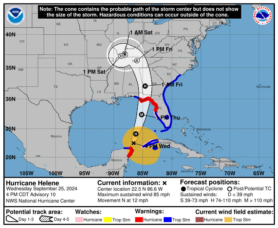
At 400 PM CDT (2100 UTC), the center of Hurricane Helene was located near latitude 22.5 North, longitude 86.6 West. Helene is moving toward the north near 12 mph (19 km/h). A northward or north-northeastward motion at a faster forward speed is expected during the next 36 hours. On the forecast track, Helene will move across the eastern Gulf of Mexico tonight and Thursday and cross the Florida Big Bend coast Thursday evening. After landfall, Helene is expected to turn northwestward and slow down over the Tennessee Valley on Friday and Saturday.
Maximum sustained winds are near 85 mph (140 km/h) with higher gusts. Strengthening is forecast, and Helene is expected to be a major hurricane when it reaches the Florida Big Bend coast Thursday evening. Weakening is expected after landfall, but Helene’s fast forward speed will allow strong, damaging winds, especially in gusts, to penetrate well inland across the southeastern United States, including over the higher terrain of the southern Appalachians. (read more)
Fortunately, the eyewall -the area of strongest winds- is likely to be tight and small; however, the outflow wind field is likely to be very large which makes the water pushing into the coastal region more concerning.
.
Those in the impact zone should leave if possible. No-one should remain on/near the coast. A category-4 storm can and will damage structures, buildings and landscape.
This storm is very similar to Hurricane Charley which impacted the SW coast of Florida in 2005. The coastal topography can change in the 30 mile-wide area of immediate impact.
Infrastructure failure should be anticipated, and it could take weeks for restoration. The coastal communities are the most vulnerable; however, the inland impact of the storm will continue unimpeded until the eyewall crosses onto land.
That means communities inland for 50 miles will likely see consistent 100+ MPH winds for several hours. That scale of sustained wind energy will snap power poles and weaken reinforced concrete.
As the backside of the storm then reverses the energy direction, any already compromised structures will not withstand the additional pressure. In many cases the backside of the storm is worse than the front.
If you are at/near the coast, in the zone of eyewall uncertainty, the time to get out is tomorrow. Don’t wait. Take all mandatory evacuations seriously. If you are inland, prepare yourself for a long duration of extensive wind damage followed by an extended power outage.
Do not panic or stress with dark imaginings. However, all hurricane preparation should be rushed to completion.

Due to the speed of this storm, and the rapid intensification strength, all interests in the coastal area should immediate rush to completion their hurricane and storm preparation plans. Thursday is likely the last day to prepare your property and personal effects. Do not delay. Pay attention to the warnings and guidance of local officials.
If you live in an evacuation zone, be prepared to respond as soon as instructed. Take this storm seriously. Slight variations in the storm’s path can create major changes within any impacted region.
My sister and I were all set to go to Tucker’s show in Greenville, SC, tomorrow night with free tickets and dinner from PreBorn. The Hyatt let us cancel without a penalty and she is relaxing in her apartment in Atlanta, which is getting a lot of this storm. Driving there and walking
3 blocks to the arena was going to be unpleasant, to put it mildly.
We know it’s the “correct” decision but still disappointing. May this be the biggest problem any of you have with this storm.
The good news is we are both prepared for anything the storm gives us, although it won’t be much here on the SC coast.
Wise move. I have a relative in Simpsonville
I know but I hate having to be sensible…
Last week was the 35th anniversary of Hugo. I didn’t live here then but saw damage months after when I visited Myrtle Beach. This isn’t Hugo, thank heavens, but discretion is the better part of valor and there is no reason to put ourselves in harm’s way.
And I would say we’re getting a dry run for what’s coming tomorrow, but it’s certainly not dry here north of Atlanta! Evidently what we’re getting all this rain and storm from earlier today is coming from the west side. Just hang on tight tomorrow! Lord knows how much rain will have then! Take care Mari, and glad to have ya’ here! 😉
Ditto from Union County, NE GA mountains.
God bless, “Storm Treepers”! 🙏💕
So we had 166 years here without a Hurricane before Idalia. This will be the third hurricane in three years, all in late August or September. Idalia was still a force 1 when it got here. This could be interesting…
As for the Big Bend of Florida, the storm surge is forecast to be 20 feet, and the NHC is saying it is not survivable.
Funny how many hit one if the reddest parts of Florida.
That area is NOT red. You are talking Tallahassee.
I live in Tallahassee, and all the gob’ment jobs guarantee democrat dominance. Talk to the producers (tradesmen, etc) and they’re republicans, talk to the parasites (gob’ment employees) and they’re dems or socialists/communists. Every. Single. Time.
It is at times like this I remember “The Panhandle Exemption”. Self serving bureaucrats exempted themselves from stricter building codes because many of them who didn’t live there had second homes. The exemption did not age well. They eliminated it when the unwashed realized what they had done.
Check the records for the last twenty years. No direct hit on Mara Lago. This in an area of Florida that historically gets hammered every few years.
The Almighty is protecting someone . . .
Interesting!
Praying for Florida and the Gulf Coast where we live as well. Amen.
Battening down the hatches!
Maybe this will give DeSantis his sea-legs again, and he’ll get back in the saddle.
Dear Lord, please protect all those in this storm’s path from any and all harm. Guard and keep safe all the responders who are there to protect and serve their fellow man. Amen
Amen.
Amen
Amen.
Amen
Amen
At the end of his video, National Hurricane Center Deputy Director Jamie Rhome told us to go to hurricanes.gov for up-to-date information. Notice that it’s plural – hurricanes.gov, not hurricane.gov.
hurricanes.gov automatically redirects to https://www.nhc.noaa.gov/ .
Well, hurricanes dot government IS a lot easier to remember than the full name.
NWGA has many schools already closed Thursday and Friday. I believe more for intense flooding, as we are having good amounts of rain now due to a “cold front” totally unrelated to the hurricane. That, in combo with the rain and wind from Helene will probably make for some pretty major issues in our rural areas. Just FYI.
Prayers for those in the path and for those who will be sent for rescue, recovery and reconstruction. May our Sovereign and omnipotent God protect all🙏🏻.
Praying for the safety of all.
Please stay as safe as you can. My prayers are with you.
If this storm is anything like Charley the damage will be the surge and tornados. Charley was moving around 24 mph when it hit Port Charlotte. Tornadic damage began there and continued north up the middle of FL.
Best wishes to all!
Thank you so much for the sharing your wisdom. 🙏🏻🙏🏻
Prayers for all in her path and also praying that she does not live up to expectations. This area of the state has been so battered already. So many in the area are not in the position to weather another storm emotionally or financially.
Sounds like gonna be almost like a tsunami at point of impact. I’d be westbound on I10 with the hammer down if I were located in the panhandle area
Interesting how far inland it is to go.
Prayers for all in the path. I have family in the line, haven’t heard what they are doing. I hope they remain safe whatever their decision.
Here in Pa. I recall Agnes in the early 70’s was a total mess in damage.
As much as I don’t like Meatball, this is a decent presser.
This could be the storm that exposes DeSantis for the insurance reform bill he signed that eliminated prevailing party attorneys fees in first party insurance cases. In layman’s terms he got rid of the only reason why insurance companies would ever fully pay a claim. Now their worst day is you pay for your own lawyer and the costs to sue your own insurance company for denying a valid claim. When this passed and eliminated Florida law that had existed for over 100 years in exchange for no reduction in insurance premiums I said if we get hit by a major hurricane the blue tarp will become the state flag of Florida.
We’re going to get a pretty strong outflow band in an hour and a half here in SWFL. Something weird about this blow is that it is dragging a lot of lightning along those bands. We had that happen with one band around 4:00pm.
So, on your critical electronic stuff, if you’re in Collier, Lee, Hendry, Glades, etc., unplug it.
If you have backup off grid solar (DC/AC), get that output plug from the inverter unplugged from the transfer box. We had a ground wire pole strike that went into a pretty pricey inverter that totally fried it. That was totally special.
I’m in Suwannee County taking care of disabled daughter. Many preparations are being made here at the Advent Christian Village which got hit by Idalia last year and Debby this year.
Another daughter is in Tallahassee and will be staying home through the storm because her husband is on staff at Tallahassee Memorial Hospital.
It’s gotten very windy and rainy here at the Village already. The store on campus will be open until 2pm…then all but essential services will be shut down. This organization has done a magnificent job through all the storms and haven’t had any deaths or injuries so far. This retirement community dates back to 1913 and has about 900 senior residents, a lodge, stores, campground, clinic, exercise center, nursing homes, assisted living, independent living homes, apartments and many social activities and resources.
Will keep you posted as long as we have power and internet.
Help is already in place or on the way!
CityofTLH Update: Mutual aid crews from five states are en route and will arrive late tomorrow. Crews are coming from Missouri, Louisiana, Ohio, North Carolina and Oklahoma to assist with response and recovery efforts. Additional crews will be brought in from around the southeast once the hurricane’s path has developed.
… and a topic to which Sundance has devoted entire articles:
(the linemen, not DeSantis)
DeSantis: ‘Thousands’ of Linemen Coming to Florida
Ohio crews were southbound after Hurricane Ike, but had to return home. 70-80 mph winds, a few days after Ike landed, took out so many trees, half the Midwest lost power.
I’m in the ‘red zone’ in Madison, Florida. This is the third hurricane that has come right at us. The first one in August 2023 knocked down 27 trees in my backyard and ripped my roof all but off. There was $36,000 in damage. We had a smaller hurricane hit us in early August 2024 which knocked down three more trees. No real ‘damage’ damage, but another four trees were blown down. I’ve never been afraid of many things, but this one looks like it a once in a lifetime storm.
Joy.
Prayers for you.
May God bless you and protect you and everyone in the path of Helene🙏
🙏🏻
Evacuated.
I’m in GA, but my niece and her family live in Sopchoppy, FL. Niece and her daughter are heading north to my brother’s house, but her husband is a FL game warden and is staying on duty.
Any idea as to what they might expect to hit their house in terms of a storm surge. They’re 7.1 miles off the bay and 10 miles off the coast. How far does a 15-20ft storm surge reach inland?
to where the land is higher than 20 ft, roughly
The water will release and lessen to the side of the storm along the coast as well, so that’s not going to hold as true. I’m just curious as to if it’s expected to have 15-20ft at the coastline, how much that level will drop, over a distance, as it enters the mainland.
The problem from the storm surge will be the water backing up through the streams and rivers flowing out to the bay. The house will not see white caps but the nearest surface water body like a pond, stream or river will be the threat.
Saying prayers for everyone. Local reports here in NC are particularly alarming for our beautiful mountains. There could be devastating flooding there. We’ve had so much rain in the past week, we just can’t take much more.
Watauga County is under a tornado warning until 10:30pm
I get a bad feeling, this is not it. It is what is behind it. There is a convergence coming in behind this. Everyone stay safe and use your good judgement. Stay safe.
Hernando county all is quiet at the moment. Looks like we dodged a much bigger bullet, so far. Our local news said 25-35 mph sustained and 60’s to 70 gusts. Off to bed.
Helene’s explosive forecast one of the ‘most aggressive’ in hurricane history
Dinah Voyles Pulver, USA TODAY
Updated Wed, September 25, 2024 at 6:51 AM PDT
The forecast for Helene to transition from a potential tropical cyclone to a Category 3 hurricane appears to be the fastest progression ever predicted for a depression by the National Hurricane Center.
“They had never forecast a major hurricane within 60 hours for a disturbance below tropical storm level,” said Sam Lillo, a meteorologist…..
https://www.usatoday.com/story/news/nation/2024/09/24/hurricane-helene-forecast-aggressive/75365007007/
We live on Sand Key, Clearwater Beach, Florida. This island is highly protected by police and sheriff. We are battened down in our Condo Building (many times at this time of year due to hurricanes). All 3 bridges will be shut down tonight or tomorrow and only residents with PROOF of residency will be allowed on the island. We are, as always praying for everyone and anyone in the path “Hurricane Helene”. And especially The Last Refuge illustrious Publisher and Editor: Sundance.
Please pray for all those in the path of this hurricane. And to all who protect us during this time. Amen.
Jordan Schachtel @ dossier.today
@JordanSchachtel
If you’re in the hurricane cone in N. Florida, you want to drive WEST, per Florida Emergency Management. Free Uber rides to shelters w/ the code HELENE RELIEF.
The storm surge will render some areas uninhabitable. You will not be able to ride this out. Please please evacuate.
Following the past track versus the projected track on my weather app (Fox 35 Orlando app, on Kindle and Android phone). Forecast track still has Helene dead center on Tallahassee, but the plotted track (past) has been consistently turning West toward the peninsula.
I’d bet my last dollar landfall is just north of Tampa, and nowhere near Tallahassee.