[National Hurricane Center Link] Ian is now a hurricane and expected to intensify quickly tonight and tomorrow exiting the Caribbean into the Gulf of Mexico as a major hurricane. Cone of probability for landfall arrival in the U.S. is still fluctuating. However, all west coast Florida residents should be finalizing their preparations today and tomorrow. Our chainsaws are sharpened, gear packed, toolboxes loaded. Today, we finish securing our property.
As a general rule, take cover from wind – but evacuate away from water. Dangerous coastal area storm surges are now predicted from Fort Myers north into Tampa Bay (south side of storm). Please outline your communication plan with your family. Select a specific person outside the area to be your immediate contact. That person then relays information to the rest of your family. Please do this [Example Why].
At 1100 AM EDT (1500 UTC), the center of Hurricane Ian was located near latitude 19.1 North, longitude 82.7 West. Ian is moving toward the northwest near 13 mph (20 km/h). A north-northwestward motion is expected to begin later today, followed by a northward motion on Tuesday with a slightly slower forward speed. A turn toward the north-northeast with a further reduction in forward speed is forecast on Wednesday. On the forecast track, the center of Ian is expected to pass near or west of the Cayman Islands today, and near or over western Cuba tonight and early Tuesday. Ian will then emerge over the southeastern Gulf of Mexico on Tuesday, pass west of the Florida Keys late Tuesday, and approach the west coast of Florida on Wednesday into Thursday. (link)

Right now, you are in control. Do not be alarmed – but take every preventative measure your individual situation needs. Work your hurricane plan and stay focused on what you do control. Proactive planning prevents piss-poor performance. Work the plan, step by step and focus on what is in front of you. Ignore the dark imaginings and turn off the national media. Pay attention to your local officials and local media.
Do your laundry. Sanitize and stage your water storage. Inventory your supplies. Organize your tools. Fill your freezer with water jugs to take up room and freeze. Test your generator. Stage your extension cords. Stage your battery powered devices. Test your weather radio. Take small steps to prepare. Secure your home. You are in full control.

The #1 priority is to keep calm. Keep stable. If other people around you are panicked, do not let it impact your plan. Stay focused. Stay organized. Stay in control. I cannot emphasize enough how important it is for everyone around you and your family.
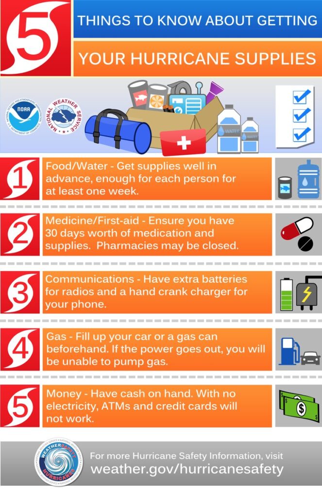
Check your hurricane supplies of shelf-stable food, water, medicine and don’t forget pets. Prepare for the worst and hope for the best. Everything is replaceable, except you and your family. We have a lot of Treepers in the path of this storm. If you need assistance, use the comments section of any ‘Update thread’ to reach out, or use the email address in the upper right of the site.
Right now, you are in control. Have a solid plan, work that plan – stay busy, and don’t get caught up in the hysteria. Try to avoid national media hype. Stay updated via your local news stations. Monday afternoon/evening looks like the key day impact zones will be identified. Reach out to your neighbors; touch-base and check to see if they are okay or need anything. Community restoration begins before the storm arrives. Look out for each-other.
Regarding any evacuation plan, please pay attention to your local officials who will be coordinating with state Dept. of Transportation. As the path and impact zone of the storm becomes more predictable your local officials will alert to best route(s) for evacuation.
For those in the cone of uncertainty; remember, planning and proactive measures taken now can significantly reduce stress in the days ahead. Plan when to make the best decision on any evacuation (if needed) consider Monday the decision time-frame. As a general rule: take cover from wind – but evacuate away from water.
DAY ONE (Sat/Sun)
- Determine Your Risk
- Make a Written Plan
- Develop an Evacuation Plan
- Inventory hurricane/storm supplies.
- Withdraw cash based on plan/need.
- Get gas and storm supplies
DAY TWO (Sun/Mon)
- Get Storm Update
- Assemble and purchase any missing Hurricane Supplies
- Contact Insurance Company – Updates
- Secure Important Papers.
- Update/upload your phone data.
- Strengthen and Secure Your Home
- Discuss Evacuation Decision with your Family.
- Fill freezer with 3/4 full water jugs.
DAY THREE (Tue/Wed)
- Get Storm Update
- Re-Evaluate your Supplies based on storm update
- Finish last minute preparation
- Plan for a minimum of THREE DAYS without power
- Assist Your Neighbors
- If Needed – Evacuate Your Family
.
Communication is important. Update your friends and family contact list. Stay in touch with family and friends, let them know your plans. Select a single point of contact for communication from you that all others can then contact for updates if needed.
Today/tomorrow are good days to organize your important papers, insurance forms, personal papers and place them in one ‘ready-to-go’ location.
Evaluate your personal hurricane and storm supplies; update and replace anything you might have used. Assess, modify and/or update any possible evacuation plans based on your location, and/or any changes to your family status. Fill car with gasoline. Review prescriptions, refill if needed.
Check your shutters and window coverings; test your generator; re-organize and familiarize yourself with all of your supplies and hardware. Check batteries in portable tools; locate tools you might need; walk your property to consider what you may need to do based on the storm’s path. All decisions are yours. You are in control.
Consider travel plans based on roads and traffic density. Being proactive now helps to keep any future stress level low. You are in control. If you have pets, additional plans may be needed.
One possible proactive measure is to make a hotel reservation further inland that you would consider evacuating to. Follow updates of the storms’ progress; make reservations if determined; you can always cancel if not needed. It is better to have a secondary evacuation place established in advance. Being proactive reduces stress. Even if you wait until much later to cancel, it is better to pay a cancellation fee (usually one night charge) than to not have a plan on where to go. Trust me, it’s worth it. Protect your family. Make the booking decision in the next 36 hrs.
♦ Look over the National Hurricane Center resources for planning assistance.
♦ Also a great resource – CREATE A PLAN
Prayers to all in the path.
Pray.
We just got a pretty fast moving rain squall from the northern outer band.
This is going to be a wet one. Some ‘caines aren’t so wet.
Watch the flooding issues if you’re in a low lying area in SWFL–the ground is pretty saturated now from the last two weeks of afternoon and evening rains.
Akindole true we have had over 12″ of rain in last 10 days in SRQ county. Groundwater is only below surface. No Name Storm hit Charlotte Harbour 9-13-2000 and did a lot of damage. The wind speed nobody knows but most likely 75mph. We lost power for a week.
Most native FL folks already have their preps ready to use if needed. Wal-Mart was limiting bottled water to one case on Saturday- friend said it was “crazy” at checkout.
Y’all take care.
Our aquifer is brim full west of Ocala.
I’m in coastal South Carolina, about 250 miles from the current path and we are expecting about 3.75-4 inches of rain but winds only around 15 mph.
Given the accuracy of our everyday forecasts, that means we could get anywhere from 0 to 10 inches of rain. They aren’t too reliable here. I’m guessing the effects from the ocean cause a lot of that but you would think those would be taken into account.
Predictions are just as unreliable everywhere else. My neighbor wants to be reincarnated as a weatherman because “nobody could be so wrong so often and still keep a job.”
Uh, Biden?
Here’s a breakdown of which counties have issued mandatory evacuations and which zones.
Citrus County
No mandatory evacuation orders issued at this time.
Hardee County
No mandatory evacuation orders issued at this time.
Hernando County
Voluntary evacuation orders have been issued for all areas west of U.S. Highway 19, which includes evacuation zones A, B, and C, the county said.
All residents living in coastal and low-lying areas, as well as manufactured homes county-wide, are included.
People are advised to seek safe shelter with family or friends that reside in a safe structure. If this is not a possibility, a public shelter will open at 9 a.m. Tuesday …t
Highlands County
No mandatory evacuation orders issued at this time.
Hillsborough County
Hillsborough County officials on Monday announced a mandatory evacuation order for all residents living within Zone A in advance of Hurricane Ian.
A voluntary evacuation is recommended for residents living in Zone B. These evacuation orders will go into effect at 2 p.m. Monday.
Manatee County
Manatee County is announcing a mandatory evacuation order for residents living in Zone A, and a voluntary order for those living in Zone B. These orders go into effect at 8 a.m. on Tuesday.
Pasco County
No mandatory evacuation orders issued at this time.
Pinellas County
In anticipation of impacts from Ian, Pinellas County leaders met at 10 a.m. to determine if they should issue a local evacuation order. While Sheriff Bob Gualtieri said mandatory evacuations will eventually come, they have not been issued yet.
However, Emergency Management Director Kathy Perkins said leaders are encouraging people to evacuate, particularly if they live in storm surge levels A through C. If people already have plans to leave and/or have a place to go, Perkins said they should leave Monday.
Any tourists who are currently staying here should plan on leaving as soon as possible.
Polk County
No mandatory evacuation orders issued at this time.
Sarasota County
County officials have ordered an evacuation for people living in Zone A. This includes people who live in a mobile home regardless of zone.
https://www.wtsp.com/article/weather/hurricane/hurricane-ian-evacuations-tampa-bay-hillsborough-pinellas-sarasota/67-373f4888-88b4-4cc6-89e5-7c35795a3e00
I used to stay in Pinellas County. During the last hurricane we were not there. I was online with a next-door neighbor. The area had been evacuated but they stayed. They live in a 20 story block of concrete that did not suffer any damage our place also was undamaged, a one story block of concrete. I like the place, sadly I am unlikely ever to get back. Lots of friends and good times. Getting old can be a bitch.
Zone A evacuate tonight. Zones B and C evacuate tomorrow. Pinellas County. Some emergncy shelters open.
If the eye of the storm comes ashore at, say, Tarpon Springs as a cat 4 or 5, this would be the worst case scenario for Tampa Bay. Clearwater and Largo would become islands as the rest of the immediate vicinity becomes submerged. The elevation of McDill Air Force Base in Tampa is about 3 feet above sea level. The storm surge will pile into Tampa Bay. If they’re still thinking about evacuationg the area, they need to think faster.
Keep Calm and Carry On.
Ron DeSanta has sent Ian to Martha’s Vineyard ,
Really?
Storm surge up to 5′ to 10′ expected around Tampa Bay from #Ian. In comparison. CAT 1 Elsa (July 5-7, 2021) brought around 2-3′ of surge to our west coast. Tropical Storm ETA (Nov 11-12, 2020) brought up to 4′ of storm surge. ETA made a mess. ETA was a tropical storm.
Lived in St Pete & Clearwater for 10 yrs, worked at Ft Desoto Park for 7. Thinking the Fort itself might be what survives.
Been in contact with friends in town they are bracing for it, east side of storm parallel to the coast for miles is devastating.
Everything pushed into the bays, nowhere rain to drain until next out going tide.
Rain has started here on east coast, most likely going to get it through Wed/Thu.
Can almost hear the crying about Lake Okeechobee already.
Always the same–we need more money.
Oh by the way the phrase used on TV news “hunker down” should be forbidden.
Praying for Florida
Let’s hope the dry air in that cold front coming down knocks the soup out of Ian as it gets close to Tampa. As the track looks now the eye or near the eye of the storm would pass over Crystal River where the largest electric generating complex is in Florida. It has four units, all either coal or natural gas. The nuclear unit was shut down years ago. If it takes a bad hit a lot of the grid in N. Florida is going down.
I posted much the same in the Presidential thread. The coal was being phased out for NatGas.
Over 20 years ago I worked on both Units 1 and 2. Earlier I said 3 but I was mistaken because that was the nuclear plant. Both units were coal fired back then and both were big Combustion Engineering systems with Raymond bowl mills and exhausters feeding big wet wall boilers. The boilers in those units were hung from huge I beams with springs from the top to allow for the 8 feet of vertical expansion when they got to temperature.
As I mentioned before the units use sea water which they condense into fresh water. The water inlets have huge baskets at their mouth to prevent any large sea life from being sucked in. They periodically pull the baskets and a marine biologist counts the different species of sea life caught in the basket. The complex has it own fishery where they raise replacements for the species caught and release them back into the gulf.
They converted their coal ash system from slurry to pneumatic while over the several annual maintenance shut downs I and my crew worked there so they were discontinuing use of their settling ponds.
Knowing a bit more about the operation of coal fired plants than the laymen it drives me crazy when I repeatedly see on the “news” how they misrepresent so much about the operations of those kind of facilities. To this day they still show water cooling towers with steam coming out the top and claim they are smoke stacks emitting pollution.
Though the water they return to the gulf has been cooled it is still considerably warmer than ambient and during the winter the Manatees love it!
The Sabal Trail Pipeline was supposed to be the future of the Plant. Thanks to joetato I don’t know what they plan to do. Duke has been charging all customers a little something extra for some time to clean up a concrete holding pool that has been leaking radioactive material into test wells in the area. They knew the tank was bunk when they bought it. I had heard talk of a proposed LNG port at Crystal River, that would have dovetailed with the Suncoast Parkway Extensions which would have destroyed our way of life out here, from a County Commissioner.
To CR and rah.. back in 1980’s I was teaching in local HS .. physics .. took a tour at plant.. was told then only 20% was nuke the rest coal.. shown how scrubbers cleaned the burn to be useful as phosphate.. trucked away.. seem like very efficient system..
Students found my report very interesting … believe or not had some that thought nukes actually traveled thru wires into their house… sad but a lot of ignorance on that subject .. also believed “smoke” from towers lie ..hope I re-educated some ..🤣👍
🇺🇸💪😀👍
I too have worked at a coal fired power plant that was of the ancient variety. It was eventually converted to gas and then finally closed down and replaced by a cleaner burning modern gas turbine plant. It was inland though. Frequently knocked offline by thunderstorms. I really hope Floridians take these evacuation notices seriously!
Don’t forget to live your best life, each and every day.
Prayers:
Father, all the elements of nature obey your command. Calm the storms and hurricanes that threaten us and turn our fear of your power of your goodness. Grant this through our Lord Jesus Christ, your Son, who lives and reigns with you and the Holy Spirit, one God, forever and ever. Amen.
AGGIEGIRL, We as believers were instructed in scripture to take control, not to ask the Father to do it for us. The Father gave us that authority back in Genesis and then Jesus showed us how to do that while he was here in the flesh. So, use your rightful authority and order the storm to calm and not bring destruction to the land.
What will be will be.
The Serenity Prayer is also a good guide for how to live.
Amen!
For those in the storm path and surge areas….
Another powerful prayer to St. Joseph, as an intercessor for our needs:
Oh, St. Joseph, whose protection is so great, so prompt, so strong,
before the throne of God, I place in you all my interests and desires.
Oh, St. Joseph, do assist me by your powerful intercession,
and obtain for me from your divine son
all spiritual blessings, through Jesus Christ, our Lord.
So that, having engaged here below your heavenly power,
I may offer my thanksgiving and homage to the most loving of fathers.
Oh, St. Joseph, I never weary contemplating you and Jesus asleep in your arms;
I dare not approach while he reposes near your heart.
Press him in my name and kiss his fine head for me and
ask him to return the kiss when I draw my dying breath.
St. Joseph, patron of departed souls – pray for me.
Amen.
It has been known to those who hear, pray, or carry it..that they will never die a sudden death nor be drowned nor poisoned, nor fall into enemy hands, not be burned in a fire or defeated in battle. It was found in 50 AD…A Pope sent it to Emperor Charles when he was going into battle.
Some people may not know, SD is CERT volunteer. That makes him a kind of expert in my book. If you have a particular issue, reach out here, do not hesitate. Miracles do happen. I have a 10am flight on Saturday, out of Atlanta. Oh well.
Bless and keep everyone in harms way..
Please pray for the animals of the land, sea, and air.
Ma’am, it’s the domestic animals that will need the most prayers, the animals in Florida have weathered hurricanes long before we were here.
HAVE ONLY FOLLOWED CTH FOR A FEW MONTHS AND HAVE FOUND IT HELPFUL AND ENCOURAGING. I WONDER, HOWEVER, IF IT IS NORMAL FOR CTH TO POST SO MANY UPDATES ABOUT TROPICAL STORMS AND HURRICANES, AS IS BEING DONE WITH IAN, THAT ARE PREDICTED TO HIT OUR COASTS? OR IS IT THAT YOUR STAFF/OFFICE IS LOCATED IN FL OR IN THAT AREA AND THAT’S WHY SO MANY POSTS? ARE THIS MANY UPDATES OPERATIONAL PROTOCOL? THX
Yes.
🤣🤣🤣
I would say ‘Yes’ to questions 1 and 3 and ‘No’ to question 2.
YES? to which question?
Sundance and many of us are Floridians – and impacted personally by hurricanes and tropical storms. Sundance has been known to go out with his chain saw and help neighbors clear their streets and yards.
thank you
Being a relative “newbie” to Florida, I certainly appreciate Sundance’s updates. Having settled in Florida after living in Kansas for 35 years, I am grateful for the “preparation time” that a hurricane affords, in relation to almost zero “preparation time” for a tornado. Thank you, Sundance.
Yes,,he is CERT responder.
Sundance lives in Florida and is a rather considerate citizen. He takes it upon himself to help his neighbors after storms by helping to clear downed trees etc. With downed power lines that can be a deadly job.
Many people here, me included, have more than a passing interest in meteorology.
Yes it is normal to have so many hurricane posts. I’m sure it is helpful to anyone living in Florida.
Personally, I want to thank Treehouse for such comprehensive info and updates. A few years ago a young family member was living in Florida and had no idea what a hurricane is like. She listened to coworkers who said it was no big deal; she didn’t realize they were native Floridians who were fairly well prepared year round and knew what to do. I sent her every bit of info I could and made my own lists to check off to make sure she had everything she needed to be safe. She needed all that info since her employer didn’t let the employees off until 5:00 pm of the night the hurricane hit her area.
So yes, this is necessary and GREATLY APPRECIATED INFORMATION. Thank you Sundance.
Priorities. God, Family, Community….
This might help the understanding. It’s just what we do….
https://theconservativetreehouse.com/blog/2017/09/16/hurricane-irma-recovery-day-6-inland-florida-relief-efforts/
The pool guys! This story is 5 years old and is still one that stands out to me.
I remember that pool man story like it was last week, too funny. Yet we made it. We will this time too just buckle up it’s going to be a wild ride.
I’m in SC and probably won’t be affected much. Y’all stay safe down there.
Atta Boy, SD.
For many decades before the advent of FEMA, Southerners along the Gulf Coast have gone to help meet their neighbors’ needs after a hurricane hit them.
States, Counties, Cities, Towns, Communities, Religious and Secular Orgs would all chip in to lend a helping hand to the hurricane survivors. It was always needed and appreciated,… and it was always reciprocated when it was others’ time to be devastated by a hurricane.
The Fed Govt could not and cannot improve on this local grown system of communities and neighbors helping one another following a Storm. It’s all part of living “Down South!”
I have seen this system work very well for the past 50+ years as my family has owned a major 100 ton a day Ice Plant and we would be the first into the devastated areas with truck loads of bagged ice after the hurricane hit, along with the Nat Guard convoys in their Duce trucks with giant generators for hospitals and local govt Com centers and chain saws to “cut our way” into the towns or cities,… from TX to FL and all the way to the Johnstown, PA flood in the ’60s.
Catholic Charities, the Southern Baptists, Red Cross, and now Samaritans’ Purse are all indispensable resources following a hurricane strike and we have worked with all of them.
Don’t stand near the rear doors of a 18 wheeler loaded with 80,000 lbs of 10 pd ice bags following a storm in a mall parking lot with hundreds of desperate survivors,… in their rush, they will crush you against the doors when opened to make sure they get their free bag of ice. I’ve seen local LEOs in Mobile, AL have to fire their weapons into the air to stop the panicked crowd and create order out of human chaos,… a very ugly scene, to be sure.
Keep a cool head and plan on taking care of yourself first, then you can help others in need, the Southern Way, as we have always done it.
I too,SD, can personally attest to the mutual human impact of the tearful hugs from a thankful, god-fearing “Mike-the-Pool Man”,…. many of them after too many hurricanes.
Absolutely nothing is better than those who help in times of need, like you DaPicayune. I have to give credit also to electric companies. I’ve seen caravans of electric trucks moving into the storm affected areas to help get electricity back up for as many as possible.
There is no more welcome sight than electric trucks and ICE! I know a little about this as I have lived in eastern NC for most of my 70 years and have weathered 11 hurricanes. Ian won’t make it up here this time, unless it takes an unexpected turn, but I wish for the best to those in it’s path.
I want those who don’t know, that your interest and concern about hurricanes extends beyond Florida to North Carolina and above.
I have known you to cover hurricanes which hit eastern North Carolina and you have offered help in many circumstances beyond just Florida. You are a wonderful asset for all of us.
When God made you, he broke the mold because there are not many out there like you. Thank you, Sundance.
TY
Sundance I realize you are a battle tested Floridian when it comes to these hurricanes. But for your sake as well as ours please be careful! We need you!
<ARE THIS MANY UPDATES OPERATIONAL PROTOCOL?>
Yes…but posting in all caps is not 🙂
It does however effectively illustrate a state of confusion..
Yes, I know CAPS is not normal but my eyesight is quite blurry and CAPS helps me tremendously. Even now typing with lower case I have to retype a lot of what I am typing…..takes me 3 times as long. 🙁
My daughter went to college in Conway, SC (Go Chants!), about 30 miles from Myrtle Beach from 2013 to 2017. She had been through hurricanes in Maryland and heard my stories about being affected by both Camille and Agnes in western Pennsylvania but she had never been responsible for being prepared. They were living off campus for two of them and eventually evacuated both times when classes shut down but I sent her Sundance’s column about being prepared and they were in case they stayed. She still has that saved in case we ever get one here.
Do like I do. If you aren’t interested/ it doesn’t apply to you, just skip over it.
This community of Treepers is unlike any other group you will find on any other site.
We are not a random lot who have stumbled onto this site to comment.
We are a big, beautiful family of people whose names we all know. There is a camaraderie which flows through these threads which is very precious.
And those who oversee the day to day…Sundance, Menagerie, Ad rem, Weeweed…always look after our best interests. I’m so glad you found a branch in this loving Tree. As you continue to visit, I’m certain you will understand just how valuable it is that we here look after one another when occasions such as this hurricane occur. It is a place of comfort where I’m sure Almighty God is amongst us all.
There is no better or more trustworthy place to be.
Amen, Bet.
I know you feel the same, CR.
Do I remember rightly that you are in Florida? I pray you and all your fellows there dodge the worst…blessings, my friend.
Yes ma’am. I feel a high degree of confidence that I am as prepared as I could be to ride it out and deal with the sweaty aftermath or scatter at at moments notice on the Country backroads up into Georgia, if Ian became a Micheal-strength storm. New Floridians are panic buying, and gas is in short supply. Everyone forgets our system only functions when everyone takes a little bit at a time, which is why I gassed up days ago. The Heat Queens over at The Weather Channel are doing their best to terrify everyone and we need calm rational information. Thank you everyone for your continued prayers.
I’ve seen it happen as well, panic buying. It isnt pretty. But I felt you would not be one of those. I guess panic sells. I’m glad you’re prepared. Praying, as rah said elsewhere, the cold front moving south reaches the incoming and manages to take some of the puff out it. With so many prayers offered, I’ll hope the worst does not happen.🤗
To be honest, I was wondering how good these freeze dried foods I bought during the Plan-demic really are. I might just have to try a few out and rotate some stock.
😂 Won’t know til you try…
Go on…be a daredevil. And do report back. Hoping for they’re 10/10 (for frozen anyway😉)
Yep, I was in my local Publix early this morning getting propane, water and ice and only took two bags of ice because the case was getting low. My area has lots of elderly so wanted to make sure others can get theirs. Later in the evening I headed to my kids house and ran into their Publix to get doughnuts and their ice case was filled to the top so I grabbed two more bags.
I live within 50 miles inland from Cedar Key… 42 yrs…SD is right on the money with his updates…please accept for what it is .. citizen helping his fellow citizens …😀👍
🇺🇸💪😀👍
We are neighbors, Jb.
Small world isn’t it 🤣🤣👍
🇺🇸💪😀👍
Well, as we say in the Glorious South, all y’all be careful and stay safe. Gotta look after one another, even of it can be only in prayer.💕
Very nicely put, thank you.
You are most welcome, Baileysdad. It is exactly what I feel.😊
Stella, sincerest apologies for leaving you out of the sterling line up. I apologize. The old brain had one of its moments this afternoon.
Once again Betsy, you have expressed it as I wish that I could! You are highly regarded and respected here,Thank You!
Your comment, MR, has truly humbled me. Thank you, dear sir.
Yes, Sundance is active in hurricane preparedness and afterwards. There are new people here everyday who have never experienced a hurricane and need to know. It’s only when a storm threatens FL. which is why he isn’t posting much as he is out helping the state to prepare. BTW you don’t have to shout.
You have got to be kidding..☹️👎
🇺🇸💪😀👍
and please stop shouting. All caps is almost impossible to read.
He never post much on one heading for D.C.🤣
God Bless You Sundance !! Prayers and best wishes to all in Florida in Ian’s path…
I have a granddaughter that evaluated from Fla. Southern University this morning. She is coming up to South Carolina for a week.
Stay safe Fla Treepers…
I’m in Georgia. I was supposed to go to Boston until Saturday. That is until I sent the cone image to my boss. She said to stay home.
Stay safe, Florida people.
Praying! And thank you Sundance for all of the vital information you have provided for all those who could be affected.
High quality image of the eye trying to develop:
Gov DeSantis is about to have catastrophic damage to a major area of Florida.
He’s about to be removed from the campaign trail.
And he will provide the leadership to show us Floridians why he should keep his job. No campaigning is needed.
I thought it was obvious I was referencing PRESIDENTIAL CAMPAIGNING.
As our Gov, he should be busy taking care of FL. His disaster prep and response coord will make or break him. Much better measure of a leader than any campaign speech. He really stepped up during the COVID disaster and I was very grateful!
He did well during Covid. I was referencing that it would take him off the Prez campaign trail.
Look for the Occupant to make him look bad…not delivering supplies or aid and lying stating that he never “requested” the necessary lifesaving items and as a result “hundreds died”.
FJB,… Gov DeSantis and FL State Govt can quickly contract for all the gasoline, medicine, water, ice and rebuilding supplies as needed themselves from private vendors/suppliers,…. sans FEMA or any other of The Occupant’s Fed-Up Agencies “Helping Interference”.
We know that is comin.
Well-known storm chaser Jeff Piotrowski is in the Tampa area assessing the terrain as he will be there reporting it live (best he can). Worth watching.
Is he the “Blue Shed” guy?
For those who don’t know, few years back he (or somebody) filmed a tiny blue shed that *somehow* was left standing in a horrific storm.
Yes, he is the ‘blue shed’ guy! He’ll be live streaming Ian’s crash landing, along with several others.
It is just so flat. There is nowhere for water to go.
And, some parts have had a lot of water. The current track has shifted to the south part of Tampa bay. If it continues to shift downward, it will be good for the bay and bad for the area it lands.
My single mid 30’s daughter is there visiting friends. She is booked out tomorrow , Tuesday 7PM back to Denver. We tried to change her flight Southwest, but she missed a flight to Austin and then Denver today. No more availability and I suspect it is dicey if she will fly out tomorrow, even doubtful what a trip to the airport tomorrow afternoon will be like, and a return trip home to Wesley Chapel , just North of Tampa. I am her designated contact and I have sent her all the preparation info from Sundance’s latest post. She and the family she is staying with all moved away from Montgomery County TX. All are veterans of Gulf Coast storms including Allison, Harvey , and Ike, also the one that missed that I forgot the name of, but everybody evacuated for. I was away working the offshore rigs in West Africa, and my wife stayed home in the middle of Chemo. We all know what to expect, and we have ex-Venezuela good friends now in Winter Haven who are a backup plan. Asking for prayers for all of FL and for my daughter, her friends , and our friends close by.
Prayers happening. Hugs.
I believe I read an official tweet yesterday (can’t remember whose) that the TP airport was being shut down at 5:00 p.m. Found the tweet.
Looks like by Wed there will be 45mph winds or higher all along the west coast of Florida from Cape Coral to Apalachicola, with Sarasota feeling the initial brunt of the storm. By Friday noon, Cedar Key should be getting winds of 60-70mph.
https://www.windy.com/?2022093018,27.837,-83.249,8
Prayers for all from a fellow Gulf Coast resident. These are the days that you’re thankful that you don’t have to wait for your car to charge before you can evacuate your family!
Folks have gone into full blown panic buying mode in my area. I went to the Credit Union, moved some money into Checking and pulled out some cash. Unfortunately the parking lot is adjacent to a Lowe’s and a SuperWalmart. I was trapped for almost an hour trying to get out of that place. Publix was no better, I calmly walked over and grabbed some fried chicken and some extra cat litter amid chaos. When I got to the checkout I told the ladies I was not about to buy buggies worth of groceries that were going to spoil. They laughed and said in unison, “You must be from Florida!!” I laughed, paid my bill, and headed to Tractor Supply for another cat carrier, just in case.
This time of year the night time temps have been down in the mid to upper 60s or low 70s which will effect this storm biggly.
With cold air pushing down into the U.S. watch how many times this change like always.
Professional, well-known storm chaser, Jeff Piotrowski gives what he calls his worst report EVER, Says this story will be a KATRINA-ANDREW type catastrophe. He talked to professionals, in the know, and there is far worse info that will be forthcoming.
That EYE looks really creepy!
When night time temps from Tallahassee thru Charlotte NC to Savanna GA to Jacksonville Fl are in the lows 60s to 70 you can bet the cold and low pressure pushing down from the north will change it’s direction.
All that is taken it to account with each forecast, although, as Mike’s Weather Page has said – CAT 4s do what they want.
Praying for all of Florida and all the states above!
I hate to see the panic porn on this page.
Prayers and preparation along with updated information are now “panic porn”?
I see calm intelligent advise and caring posts in preparing for an event that will effect many lives.
Just what do you see as “panic porn”?
I find it extremely useful. Reside in Washington state. Some things are suggested for an emergency that I would have never thought of. Sent the list to my loved ones in three other states — not Florida.
In short, get lost.
It’s the wind gusts that scare me… we lost the majority of our roof tiles during Irma. We are directly on the coastline in Naples and those gusts of 165mph aren’t good. Thankfully no major storm surging this time. Thanks Charles for the update… those of you new to Florida, please don’t take this lightly. Once you’re in it, you have to ride it out. It can be frightening as debris hit the windows and the trees blow over. But, that said.. the homes are pretty sturdy. It’s just the cosmetics.
Be safe everyone… prayers up for everyone.
One more thing to do – Be very nice and appreciative of the people who work at the stores, banks, gas stations, etc. that you patronize.
I’m sure the people working in those places wish they had the day off, so that they could prepare for Ian. But they have to be at work, helping their customers. So they might appreciate a “Thank you” for being there at work, helping their customers.
“Hear, Here!”
Our thoughts and prayers are with you from the Hawaiian Islands.
I have family in Tampa and in Fort Myers, I’m near Orlando. Clouds are already rolling into Fort Myers.
Schools closed here in Central Florida tomorrow through Thursday at least. That call wasn’t made until 2:30 pm today. Good grief.
I’m not optimistic on the response considering the supply chain and lack of workers in just about every industry here.
Very good information. If I may suggest, Take pictures of major items in home and pictures of inside and outside of your home. For insurance purpose. Also pictures can be placed in freezer bags and put them as high as you can in your home. Bring a few with you, if you should leave. Years ago I gave all my negatives to my Mom. Just in case of a hurricane or a flood damaging my pictures. There is not much time to make such arrangements. So bring a few pictures with you if you have to evacuate. Years back my family could not get a motel or hotel room booked in time. We stayed in a gym. Check with schools outside of the danger zone to see who is taking in people. One night on the gym floor is not so bad. Prayers to all.
best coverage I know of very detailed……..hang tuff
https://www.tropicaltidbits.com/
Dr. Levi is top notch.
All the way up in New England, my thoughts are with sundance and the CTH crew – stay safe in the storm!
Latest map collection:
https://www.trackthetropics.com/ian-2022/
Naples/Tampa to Tallahassee need to make a decision by Tuesday Noon whether to stay or evacuate. There’s already 50 mile backups on freeways heading North. Evacuations are no fun, but the risk of riding out anything bigger than a Cat 2 ought to make that decision easy. If it goes Cat 3+ , and people aren’t in mid GA or TN by Tues night, it is going to be very bad. Been there and done this. If contemplating a motel/hotel reservation, do it Now. If evacuating make sure your car is reliable and carry extra gas as dead cars on I-75, 95, and 10 will bring huge delays.
https://www.dailymail.co.uk/news/article-11250329/Ian-strengthens-hurricane-heads-Cuba-Florida.html
Looks like it will hit in the area between Pine Island and Cedar Key, maybe Crystal River, Homosassa Springs. I have many friends in the area. Praying.
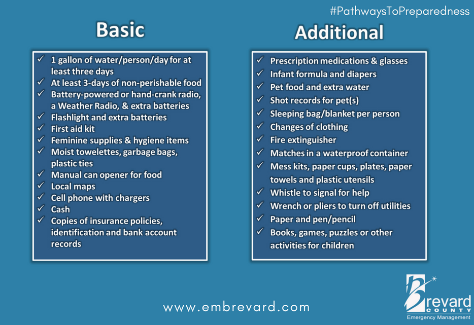
If this is helpful this is the evacuation check list we made for our POA community in SC
(when we lived there our CERT Team made this handout)couldn;t post pic of
checklist so I retyped it..
Decide where to go & routes to get there, Notify other family members
where you are planning to go
Fill all autos with Gas-pack jumper cables
Get Cash (ATM will not work if power is out)
Cover windows
Brace all doors including garage door
Fill Tub with Water
Charge all Cell phones, I Pads, Laptops
Be sure to have GPS in the car-have maps as backup
Flashlights with extra batteries, Emergency Radio,
Emergency service phone numbers
Store all lawn furniture/grill in secure location
PACK-FOR MINIMUM THREE DAYS
Medicines and medical devices
Copy of Insurance policies and Property deeds
All necessary ID and passports
Pack your valuables
Clothing for several days, shoes and boots
Drinking water, Food non=perishables
First Aid supplies including scissors and knife
Toiletries
Towels blankets and sleeping bags
WHEN LEAVING
Shut off water at main valve
Unplug all electrical devices
Shut off all circuit breakers EXCEPT Refrigerator/freezer
Turn off Main Gas Valve including inground propane tanks
Throw out perishables from Refrigerator
PETS
Pet food, Water and thier dishes
Carrier and crate for each
Collars. harness and leashes and any medications
Current photo of your pets
For everybody that will use a generator at their home, remember to open the main breaker on your electrical panel to isolate your home from the grid. That way you won’t backfeed into damaged electrical lines and electrocute a lineman trying to repair damage.
Label your canned goods with a permanent marker. Labels fall off if they get even a little bit damp.
Well., well, well. The GFS and European model ensembles have switched positions. The GFS yesterday afternoon and last night shifted the track further east and is very much like the track the NHC is currently putting out with the storm very close off shore from Tampa.
The European has shifted its track further west showing the track far enough from Tampa to make a big difference in the amount of surge and wind at that location.
If you want to see the tracks, they are on Levi Cowen’s latest video here:
Tropical Tidbits
Both show the storm almost stalling at the about the latitude of Tampa. But the European now shows the strom tracking off to the NW up towards the panhandle and weakening considerably as it does so.
So take heart because the fact is the European model has a better record for accuracy than the GFS. Don’t be surprised if you see the GFS track start shifting back west again.
It missed you.
Blue locust repellent… The natives say, bring it!
Oha boy. The European ensemble is dancing all over the place. Now shows a big shift east with the storm coming ashore in a similar location as Charlie near Charlotte bay. Gets Tampa out of the woods but brings into play Central and Western FL, GA, SC.
Joe Bastardi
@BigJoeBastardi
Big shift east in the euro ensembles means stronger hit further south and ups the ante for the Carolinas and Ga
this will be a different kind of storm for many Floridians due to it’s different dynamics as far as it’s impact.. it will be more of a characterization of a Upper Gulf Coast storm..
although not having days and days and days of pushing and building a wall of water across the Gulf.. it will make up for that in it’s intensity..
..steeper water..
storm surge.. a surprising one.. in an area of Florida that have rarely experienced.. those caught in the storm surge red zone.. it will be a storm to remember..
keep your life jacket close by.. and maybe an oar.. to dodge the debris.. or to whack the looters..
it’ll be alright.. don’t panic.. it’s just water.. and wind.. and waves..
..enjoy the ride..