Tropical Storm Elsa is anticipated to make landfall along the western coastline of Florida later today. With Elsa moving through warm water in the southern Gulf of Mexico it is possible Elsa will gain hurricane strength prior to landfall. Residents along the Western coastal area of Florida should be prepared. As long-time readers are aware, depending on events later today, my CERT responsibilities will likely limit my posting (tool boxes loaded).
Elsa’s winds extend outward to 70 miles as it travels through the gulf coast area. However, this system is pushing a lot of water on the southeast quadrant. Moderate storm surge and flooding is an issue for the coastal areas due to the amount of rain predicted. This is a very wet system. Treepers in the Sarasota/Tampa Bay area northward to the bend should pay particular attention tonight. Power outages will be more sporadic as they result from wind strength/duration.
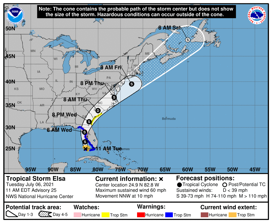
National Hurricane Center – […] “At 1100 AM EDT (1500 UTC), the center of Tropical Storm Elsa was located near latitude 24.9 North, longitude 82.8 West. Elsa is moving toward the north-northwest near 10 mph (17 km/h) and a generally northward motion is expected today and tonight. A turn toward the north-northeast is expected on Wednesday, followed by a faster northeastward by late Thursday.
On the forecast track, Elsa will continue to pass near the Florida Keys this morning, and move near or over portions of the west coast of Florida later today through tonight. On Wednesday morning, Elsa is forecast to make landfall along the north Florida Gulf coast and then move across the southeastern United States through Thursday.
Maximum sustained winds are near 60 mph (95 km/h) with higher gusts. Slow strengthening is forecast through tonight, and Elsa could be near hurricane strength before it makes landfall in Florida. Weakening is expected after Elsa moves inland.” (read more)

SD, if you are activated, God’s Speed and stay safe.
God, please protect and stay beside all in Elsa’s range of effect, and all responders. In Jesus’ Name
AMEN
Good info, Sundance. I have really enjoyed following Weatherman Plus over on YouTube. Here’s his latest on Elsa –
Sundance, prayers for your safety, and your family, as you go out to help others after disasters.
Thank goodness Florida has Gov. DeSantis.
And in the tradition of every hurricane we have…
Time for a BBQ and cocktails!
Probably. Just got off the phone with a friend in a Sarasota retirement condo. They’ve already prepared the sandwiches. But best to prepare for the worst.
So far, nothing out of the normal. There could be some flooding, which will drain quickly and isn’t a big deal. I pray it’s nothing worse than that for anyone on the west coast. There’s a whole hurricane season yet to come.
Well, so far it’s a nothing burger in eastern Lee county. Basically no rain and no wind (out of the ordinary). The outer bands are right below us tho, so, we’ll see what happens.
But…
That hot zepher characteristic of a ‘cain isn’t there. And, those low dark clouds you usually see whipping across the sky aren’t there either.
FPL did decide to drop our power twice yesterday (with zero wind) for about an hour and a half each, (just for good measure I ‘spect). Enough to get one in the fighting mood, drain the DC backup batteries, and prompt a gas top off in the generator(s).
Moved 4 months ago from SoCal to Sarasota County in Florida to escape the communist occupation of California. Constant wildfires in California…was terrifying. Would watch them blazing in the distance…an absolutely sickening sight and my heart would be so sad for all the victims. I live on a barrier island here in Florida so getting pounded a bit with gusty winds and rain from Elsa…not pleasant but at least I’m not frying in satans cauldron of California anymore. Just praying the power doesn’t go out…so far so good! Stay safe fellow Floridians and God bless you!
Any Floridians out there remember Hurricane Donna? That was a storm. Same track as hurricane Irma took. Similar to this storm but so much stronger. Part of the fun of living in the Sunshine State!
Hourly changes will continue.
Just a couple days ago they decided to level the remaining condo complex because they said this “Storm” was gonna to hit Miami and it was a massive lie.
Mother Nature will never be decoded and her path of any storm
Hurricane Elsa…. I thought there was a movie like that?
Elsa’s Hurricane – YouTube
Just for you TonyE 🙂
Sun is shining here in apíñelas county, but we have a tornado watch until 11:00 p.m. stay safe everyone!
Sorry that should read Pinellas!
Just received a Hurricane Warning by phone.
Called it Pennyless County when I lived there.
Worked at Ft. Desoto for 7 years, went thru Blackthorn and Skyway bridge rescue.
East coast now next to the prettiest blue ocean water and quick ride to Bahamas.
Stay safe.
We still call it that! We cross the Skyway Bridge on our way to Anna Maria Island. I envy you that quick ride to the Bahamas. You seem to be clear this time around. Thanks for the good wishes. Stay safe for the rest of the season.
Solid sky in S Desoto County. Gentle rain. Awnings down. Lawn chairs in. we shall see….
https://www.ventusky.com/?p=25.63;-84.53;6&l=temperature-2m
How long before this storm and the 90+ degree days last month are whipped up into more climate hysteria
I’m surprised it hasn’t begun yet considering the heat wave un the UK and cool weather in other parts where it should be hot..
Here in Spring Hill, all yard stuff out of the way away, shutters are up on big windows, ribs in the oven and now get a shower and wait. Got new residents in back this is their first storm been giving lots of advice, can’t do a thing avout her nerves or moine but will let you all know tomorrow how we made out. Be careful out there Sundance and lets hope the damage is small.
Stay safe. I am praying for all in Elsa’s path
Just a little info some may not know. Let me make this clear: If your in the path take their wind, wave, and storm surge warnings seriously. (Storm surge kills far more people in these storms than anything else)
That being said, the simple fact is that the methods they are using to calculate windspeeds by remote sensing have repeatedly been demonstrated to inflate the speeds as compared to actual anemometer readings from certified weather stations meeting the proper criteria. More than once I have seen them claiming a storm was a CAT III based on their remote sensing and dropsonde data but as I monitored the weather station and buoy data in real time the highest sustained one minute wind only reached the level of CAT II. In one case it was in fact barely a CAT II.
I have a good friend in Largo, FL. Looks like it may be where land fall could be. Regardless, they will be in the dirty side for an extended period. Additionally they live in a trailer home. Please keep them (J & M) in your prayers tonight/tomorrow.
Yes I will keep them in my prayers…
Mike’s Weather Page (spaghettimodels.com) is a great resource.
I brought out my shutter boards yesterday, painted a message on one, then decided to store them again.
Chester gets his annual tomorrow, three years to the day he became mine.
Send that hurricane to Washington DC ASAP
Family in Tampa are reporting a steady rain. No wind. I think those to the north will fare worse. Don’t mind me, but I figure that the Weather Wars people got this one so wrong: wanted to wipe out Mara Largo, or the Trump speech in Sarasota. Hah. What a fail.
And yes, PLEASE ELSA give the political class only a good HOSING DOWN in Washington, D.C. My GAWD. Their STENCH IS BECOMING UNBEARABLE.