First things first, for those writing and texting, I’m fine. I forget that new people don’t know the CERT work we do on the side. I’ve been cleaning, organizing and reloading toolbox containers. You don’t know how much stuff you use, lose and wear out in a year of recovery operations until you need to check inventory. Jumpin ju-ju bones we suck. My tribe is a hot mess, a scruffy mess; and I must have swept 5lbs of sawdust out of the toolbox lol. ~SD
Hurricane Idalia is already being felt on the Southwest coast. Idalia is sucking in energy from a long way, which tells me she’s going to be big, fast. Fortunately, the fast part is good, less time making life miserable. Unfortunately, the fast part is bad, the window for the evacuation decision closes tonight.
ALL PREPARATIONS should be rushed to completion. Overnight tonight we enter hunker down mode (more on that shortly). Get everything done by nightfall tonight.
[Personal non-scientific note. Every time these forecasts have a cone turn to the right; the variance of the forecast accuracy is directly proportional to the eyes distance from the Florida coast when the storm is traveling north. The closer to the coast, the less accurate the prediction… EVERY FRIGGIN TIME (including Charley and Ian).]
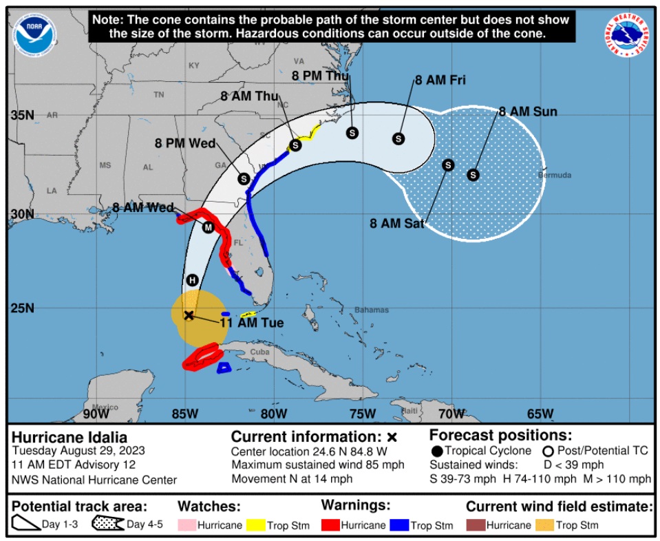
[National Hurricane Center] – At 1100 AM EDT (1500 UTC), the center of Hurricane Idalia was located near latitude 24.5 North, longitude 84.8 West. Idalia is moving toward the north near 14 mph (22 km/h). A faster motion toward the north and north-northeast is expected through early Wednesday while Idalia approaches the Gulf coast of Florida. A turn toward the northeast and east-northeast is forecast late Wednesday and Thursday, bringing the center of Idalia near or along the coasts of Georgia and the Carolinas.
Maximum sustained winds have increased to near 85 mph (140 km/h) with higher gusts. Rapid intensification is expected before landfall, and Idalia is forecast to be a major hurricane when it reaches the Gulf coast of Florida Wednesday morning. (read more)
Remember, you are in control right now, not Idalia. She takes control tomorrow. There is no need for panic or dark imaginings. Calm, prudent preparations should be taken if you are in the zone of uncertainty. A lot of change in impact zone can happen quickly with these northerly moving storms. Storm surge is expected to be significant.

Idalia will grow fast and come fast. Now predicted to make landfall as a category 3+ hurricane. Those in the cone of uncertainty should pay attention.
I hope you will understand why my proactive tips, advice and planning have modified since our experience with the September 2022 Hurricane, Ian. {Go Deep} Thankfully Idalia is not expected to be anything similar to slow moving Ian. Prior preparation advice remains solid and follows below.
This is not a message of alarm. This is a message of prudent action that can assist your consideration, as each person evaluates their situation. What you do before the hurricane hits is going to determine where you are in the recovery phase.
Additionally, and this should be emphasized and discussed within your family, if you cannot be self-sufficient in the aftermath – for any reason, then you should evacuate. Self-sufficiency in this context requires being able to cope for up to several weeks:
(1) potentially without power; (2) potentially without potable running water (3) potentially without internet service; (4) potentially without communication outside the region; and (5) with limited municipal and private sector assistance. If you decide you cannot deal with these outcomes, you should evacuate.
Additionally, as a family or individual, you should also honestly evaluate:
(1) your physical abilities; (2) your emotional and psychological ability to withstand extreme pressures; and (3) your comfort in losing daily routines, familiar schedules and often overlooked things you might take for granted.
Post hurricane recovery is fraught with stress, frustration and unforeseeable challenges. {GO DEEP}
For those in the cone of uncertainty, remember, planning and proactive measures taken now can significantly reduce stress in the days ahead. Plan when to make the best decision on any evacuation (if needed). For now, consider Tuesday night the decision timeframe. As a general rule: take cover from wind – but evacuate away from water.
DAY ONE (Sunday)
Determine Your RiskMake a Written PlanDevelop and Evacuation PlanInventory hurricane/storm supplies.
DAY TWO (Monday)
Get Storm UpdateAssemble and Purchase Hurricane SuppliesContact Insurance Company – UpdatesSecure Important Papers.Strengthen and Secure Your Home √Make Evacuation plan for your Family.
DAY THREE (Tuesday)
- Get Storm Update
- Re-Evaluate your Supplies based on storm update.
- Finish last minute preparation.
- Assist Your Neighbors
- If needed – Evacuate Your Family
Communication is important. Update your contact list. Stay in touch with family and friends, let them know your plans. Select a single point of contact for communication from you that all others can then contact for updates if needed. Today/tomorrow are good days to organize your important papers, insurance forms, personal papers and place them in one ‘ready-to-go’ location.
Evaluate your personal hurricane and storm supplies; update and replace anything you might have used. Assess, modify and/or update any possible evacuation plans based on your location, and/or any changes to your family status.
Check your shutters and window coverings; test your generator; re-organize and familiarize yourself with all of your supplies and hardware. Check batteries in portable tools; locate tools you might need; walk your property to consider what you may need to do based on the storms path. All decisions are yours. You are in control.
Consider travel plans based on roads and traffic density. Being proactive now helps to keep any future stress level low. You are in control. If you have pets, additional plans may be needed.
Look over the National Hurricane Center resources for planning assistance.

If you do not handle stress well, leave.
If you cannot be self-sufficient in the aftermath, leave.
If you choose to stay pay super close attention to the exact path of the storm. A few miles make a massive difference when you are dealing with the possibility of encountering the eyewall of a hurricane.
This is a fury of nature, a battle where the odds are against you, that you may or may not be aware you are contemplating when you are choosing to stay or evacuate. It’s not the hurricane per se’, it’s that much smaller killer buzzsaw – the eyewall- that you are rolling the dice, never to see.
When it comes to the eyewall, the truest measure of the “cone of uncertainty“, the difference between scared out of your mind (victim) and a fight to avoid death (survivor), is literally a matter of a few miles. And there ain’t no changing your mind once it starts.
The worst part of the storm surge will happen immediately to the south of the arriving storm. The onshore winds will push the water. Fortunately, with Idalia, it will likely be only one tidal cycle in duration as the storm is moving quickly.
♦ Hardening your home is a matter of careful thought and physical work. However, every opening into your structure must be protected, leaving yourself with one small exit opportunity just in case. Hopefully you have a bolted door with no glass windows you can use as an emergency exit. If not, select a small window and leave only enough room uncovered for you to get out in case of emergency or structural collapse.
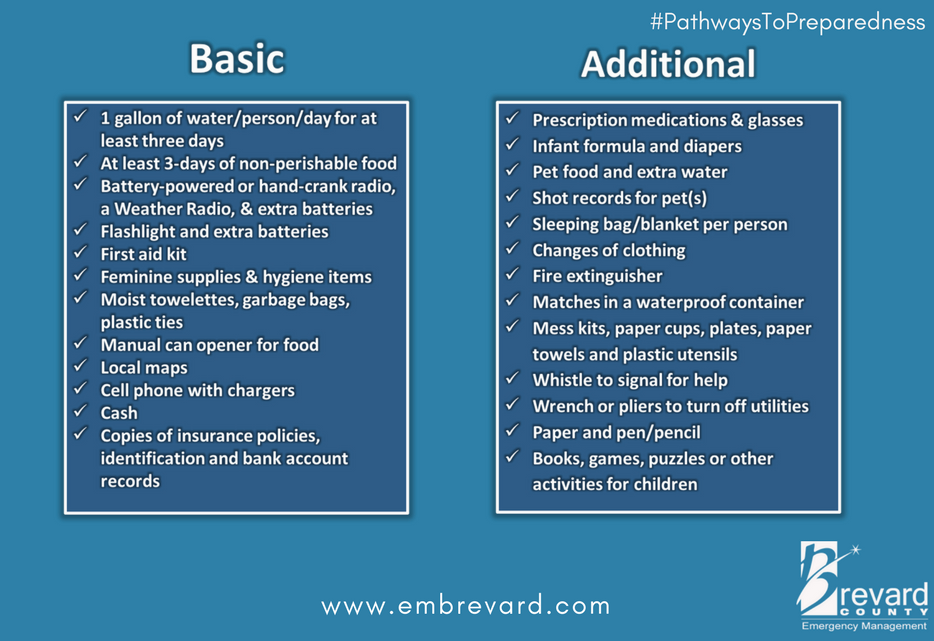
Beyond the ordinary supplies like drinking water, batteries, flashlights, battery or hand-crank radio, generators, gasoline, etc. Evaluate the scale of what you have against the likelihood of weeks without power or water. A few pro tips below:
♦ You can always tell those people who have been through direct hurricane impacts by how they park their cars. If you lose your Florida garage door, you will more than likely lose your roof. [Example Here] That’s just the reality of having a massive opening in your structure to 150 mph winds that will lift the trusses.
If you have two vehicles, put one vehicle inside the garage with the front bumper against the door to help stop the flex (do this carefully). Put the other vehicle outside blocking the garage door facing down the driveway or facing parallel to the garage. The goal is to use the aero dynamics of the car to push the wind away from the door and provide protection.
Purchase a cheap car cover to protect the outside vehicle and/or use old blankets (cable ties, bungee cords) to stop the outside vehicle from getting sandblasted and destroyed. Place double folded corrugated cardboard in front of the radiator to protect it from storm debris. [Example: A five-inch piece of asphalt roof shingle sliced through the grill of my truck during Ian and embedded in the radiator like a razor blade. I found it when the truck overheated.]
Additionally, if you live in a flood zone, or if you are concerned about storm surge, the day before impact take your #1 car to the nearest airport or hotel with a parking garage and park in the upper levels. Take an uber back home if you don’t have a friend or partner to help you. This way you know you will have one workable vehicle, just in case.
♦ Throw all of your patio furniture in the swimming pool if you cannot bring it inside. You can also use your pool water and a bucket to manually flush the toilets after the storm. Also dump extra chlorine into the pool because if your power goes out your pump will not run. The pool will turn into an algae filled mess quickly.
♦ Put three clean and sanitized 30-gallon trash cans in the shower and fill them with water before the storm. This will give you 90 gallons of water for cooking and personal hygiene. You will also need water to manually flush your toilets (if you have a swimming pool, use that water). Bottled water is great for drinking, hydrating and toothbrushing, but you will need much more potable water if the municipal supply is compromised or broken.
♦ A standard 6,500-to-8,500-watt generator will run for approximately 8 hours on five gallons of gasoline. Do not run it all the time. Turn it on, chill the fridge, make coffee, use the microwave or charge stuff, then turn it off. Do this in 4-hour shifts and the fridge will be ok and your gasoline will last longer. Gasoline is a scarce and rare commodity in the aftermath of a hurricane. Gas stations don’t work without power. Check the oil in the generator every few days. Also, have a can of quick start or butane available in case the generator starts acting up.
♦ Extension cords. If you are purchasing them buy at least one 50 to 100′ extension cord with a triple ponytail. This way you can use one cord into a central location to charge up your electronic devices. Establish a central recharging station for phones, pads, laptops, and rechargeable stuff.
♦ Purchase a box of “contractor garbage bags” and just keep them in the garage. These are large, thick, industrial trash bags that fit 40-gallon drums (Home Depot or Lowes). They can be used for trash, or even cut open for tarps in the aftermath of a storm. These thick mil contractor bags have multiple uses following a hurricane.
♦ Do all of your laundry before the hurricane hits. You will likely not have the ability again for a few weeks.
♦ Fill any empty freezer space with bottled water, remove some water to allow for expansion beforehand. You can move those frozen jugs of water into the fridge to help keep temp down after storm, if no power.
♦ Cook a week’s worth of meals in advance of the hurricane. Store in fridge so you can microwave for a meal. Eating a constant diet of sandwiches gets old after the first week. Dinty Moore canned beef stew and or Chef-boy-ardee raviolis can make a nice break…. anything, except another sandwich.
♦ Have bleach for use in disinfecting stuff before and after a hurricane. Also have antibiotics and antiseptics for use. Hygiene and not getting simple infections after a hurricane is critical and often forgotten. Again, this is where the extra potable water becomes important. Simple cuts and scrapes become big deals when clean potable water is not regularly available. Keep your scrapes and abrasions clean and use antiseptic creams immediately.
♦ Do not forget sunscreen and things to relieve muscle aches and pains. Hurricane recovery involves physical effort. You will be sore and/or exposed to the elements. Remember, it’s all about self-sufficiency because the normal services are not available. A well-equipped first aid kit is a must have.
♦ Buy a small camping stove. Nothing big or expensive, just something you can cook on outside in case of emergency. It will be a luxury when you are 2+ weeks without power and all the stores and restaurants are closed for miles.
♦ Those small flashlights that you can strap around your head that take a few AAA batteries? Yup, GOLD. Those types of handsfree flashlights are lifesavers inside and outside when you need to see your way around. Nighttime is especially dark without electricity in the entire town. Doing stuff like filling a generator with gasoline in the middle of the night is much easier with one of those head strap flashlights. Strongly advise getting a few, they’re inexpensive too.
♦ Cash. You will need it. Without power anything you may need to purchase will require cash, especially gasoline. Additionally, anyone you hire to help or support your immediate efforts will need to be paid. Cash is critical. How much, depends on your individual situation, but your cash burn rate will likely go into the thousands in the first few days. Also keep in mind, you may or may not be able to work and without internet access even getting funds into place could be challenging.
♦ Hardware. A box of self-tapping sheet metal screws (short and long) is important, along with a box or two of various wood screws or Tyvex screws. A battery drill or screw gun is another necessity. These are for use in securing stuff now, and in temporary repairs after the damage of the storm has subsided. Check all of this stuff during hurricane prep.
The track of this storm crosses Florida to the Atlantic, in the area where there is an active Atlantic hurricane. Have two hurricanes ever crashed into one another before? Is there a. chance they could meet along the coast? Would they basically decrease or increase in velocity if they merged?
I was wondering about Hurricane Franklin and Idalia meeting up too or do they just push away from each other??
Hurricanes do not normally merge. They usually repel each other like magnets of the same pole.
The current track of Idalia is similar to hurricane DORA in 1964.
This current track shows that it enters the Atlantic, and is repelled SOUTH by the tail end of Hurricane Franklin.
That is what DORA did in 1964.
After turning SOUTH, DORA then was turned directly WEST by the warm GULF STREAM waters, and came ashore DIRECTLY into Jacksonville, destroying a fourth of the city on 9/10/1964.
DORA in 1964 is the only hurricane in recorded Florida history (550 years) that has ever directly hit Jacksonville.
Jacksonville is normally PROTECTED from Hurricanes due to the INWARD CURVATURE of the Florida coastline on the Atlantic side of North Florida.
The damage done to Jax in 2017 was NOT caused by a hurricane hitting Jax directly, but was caused by FLOODING of the Saint Johns river from water flowing North from Central Florida that was unable to exit into the Atlantic because the mouth of the Saint Johns was blocked by high tides, and strong westerly winds coming from a Hurricane way out in the Atlantic at the time.
So in 2017, the water in the Saint Johns River swelled by over 12 feet, and flooded downtown, and riverfront properties. Not good, but NOTHING in comparison to what happened with DORA in 1964.
Which is what we have this time, Hurricane Idalia entering the Atlantic, and being bounced back SOUTH by the tail end of Hurricane Franklin.
The BIG question is: WHAT DIRECTION IS IDALIA GOING TO TURN TOWARD AFTER TURNING SOUTH ?
I just listened to a video by a weather forecaster, Ryan Hall Y’all (I think that video was posted here already) and he said there is a possibility that Idalia may circle back in a loop de loop back to the coast of Florida. (At about 2:31 minutes in on the video).
This Hurricane Is About To Go Nuts… – YouTube
I was born in a crossfire hurricane (jumpin Jack Flash is a gas gas gas) so yes they can!
Fujiwhara time
People are saying gas pumps sabotaged with diesel to prevent people getting away
Was a Boy Scout for many years. Be Prepared have been words to live by. Worst case planning has very optomistic results. Either you are happy you did not need it all OR you are proud that you were ready to overcome.
Prayers for all who end up in harms way.
Thank you, Sundance. I am all prepped!
Prayers to all in its path
Lord have mercy on all in the path of this hurricane. May the Lord Bless you and Keep you, may His Face Shine upon you and give you Peace.
Amen.
Amen!
Our Jumpmaster held up his hands, 5 fingers +1. “Drop yer reserves boys it’s a hot DZ. We gotta go in at 800 ft.” Pucker factor 9.9
God bless you, Sundance❣️
Wow, thank you SD.
Never have seen such preparedness info like this before.
Excellent.
Praying for all in the path! Stay safe everyone.
The skies in Bismarck, North Dakota are clear with few clouds, should last for a week. The temperature is fine, the nights cool. You can enjoy family cooking, farming style and then roam about the fields as farmers bring in the crops, tend their fields or watch cattle munch green grass as you smell the air.
Take a day trip down to Strasberg and visit the Lawrence Welk family farm but make sure you stop by Saint Peter & Paul Church in town where the interior (built by locals around 1904) will amaze you in it’s beauty and lift you up spiritually!
Or stay put in Florida’s west coast, batten down the hatches and place your bets. Take home food may be interrupted tomorrow. Swim suits optional but highly recommended!
Great list and advice Sundance. As well we have pictures of our home inside and out. That way if there is ever a question on hand with the Insurance Company, you will have the pictures as proof. Also hanging clean cloths from the fence or a small tree comes in handy. That way if you can wash a small batch of needed cloths and hang them afterwards. Saves on the Generator use. Stay safe everyone in the path.
I lived in the Va Beach/Tidewater VA area for 26 years till 2010 — this is a great practical checklist. It pays to be prepared.
God’s blessing and protection on you, Sundance – and for any Treepers in the path of the storm. Praying for it to burn out in the water and downgrade miraculously, or be diverted back into the sea. (Jesus spoke to the storm and said, “Peace, be still!” We did the same thing in faith, working for CBN in Va Beach. The media made fun of us – but admitted that it often worked!) Take care, everyone!
Bug out bags are packed, irreplaceables are ready to be loaded up, I got a few extra 5 gallon jugs dropped off with my normal order from Crystal Springs. Not much in the fridge on purpose, Vienna sausage, Chunky Soup and hardboiled eggs are at the ready, as well as an empty 5 gallon water jug to fill up in the canal to flush toilets. I loathe waiting for these things. If your crew ends up SW of Ocala and y’all happen to end up at my humble abode you can take your pick of cats as a parting gift!
I like fried bacon and hard-boiled eggs. They come in mighty handy on “road trips.”
The LORD bless you and keep you.
Much of our family lives in Levy county Florida. My brother is staying put. My mom lives with him. He is organized and efficient and I trust his decision but I will definitely be praying. Most of the time growing up, a hurricane was just a bad storm that far inland. But after surviving Ivan in lower Alabama about 75 miles off the coast, I am more wary. We were out of power for a week. Great experience. In hindsight. lol
We also live in Levy – 10 miles north of Dunnellon and 10 miles south of Williston. Nor our first rodeo, but we are also 10 years older. Will miss CTH and you all during our time without power. Prayers up. God bless.
Howdy, neighbor!
Another howdy, neighbor, 14 mi nw of Ocala
My house was damaged by Ivan, too, much further inland in west central AL. When Ivan got to Tuscaloosa, sustained winds were just under hurricane (cat 1) speed and gusts were just above it. More recently, the remnants of one that was still tropical storm strength, barely, did quite a bit of damage because we were on its right side as it was moving. That enhanced the wind some. There are still a few downed trees from it today. I am a bit further inland and in east central AL now.
Ivan…2004… I had just recently moved to East TN from Orlando. Ivan circled around a few times. He washed out the mountain road coming out of the tunnel from TN into NC on I 40.
People had never seen so much rain… over the entire southeast.
Oh, that reminds me. I passed through Charlotte NC after Hugo. There was lots of damage from it, too, and Charlotte is also quite a bit inland.
Hugo hit about 100 miles inland in southern SC…off of I 95. Little towns like Sumter, Manning, & Alcolu were hit hard by the winds. My aunt in Manning lost at least 20-25 tres on the property behind her house.
Definitely changed the landscape forever.
Praying for all. Praying for God and his Angels to surround and protect you before, during, and after the storm.
“Remember, you are in control right now, not Idalia. She takes control tomorrow.”
This is a VERY profound statement and right on point.
Once you board up that last window, it becomes hunker down mode and making sure you have everything you need inside the house.
Be safe out there! I saw a video of a rain band over the Sanibel Causeway….
My personal zone of uncertainty is that I am in another state, safe and dry, helplessly watching this unfold. Over the years, I have been blessed.
Praying for all, most especially Sundance and his little tribe.
Cape Coral Here. This was fortunately very little here than the last one that all but wiped us out. Thank God for that.
Plenty of dry socks. Tend to your feet. Swamp foot, blisters, are bad
Excellent advise. I’m printing and saving this article with my hurricane prep supplies for future use. Not in warning area at the time. Thanks.
Praying for Sundance & all who are in the hurricane’s path. May God watch over all.
Any thoughts about looters, neighborhood watch, firearms?
How about Ham Radios or CB radios which run off a car battery, any value in them?
Being that we are at least a half an hour out from law enforcement during normal times, the surrounding swamp guarantees that bodies of would be looters will be composted after being stomped into crawdad holes in short order. Few are dumb enough to rile rural Natives.
take care of bidness sundance. WE ARE ALL PRAYING FOR YOU AND YOURS. We will all be here tomorrow and the next day and the next and the days that follow. Don’t get your priorities mixed up…we ALL KNOW!
I am standing by with a full trailer loaded and ready to peel away in your direction. We have several spots to hit by wednesday nite. You have my personal email (adrem, yes?). Don’t hesitate. We have a home on the east side of florida as a temp accomodation or if things get screwy and your people just need to take a break and hang out in some ac, put toes in a pool and let the nerves ease.
IT IS GOING TO BE OKAY!
WE DO NOT FLINCH.
God Bless America
God Bless you and yours
R, regitiger
Any chance that it could take a sharp turn northwest and hit Fulton County?
You are a good man Sundance!!! Prayers for all in Florida!!! 🙏
Anyone here in the Tampa/St Pete area I would appreciate any info on conditions re: surge etc.
I wish I could help you but I am in north Texas where the only hurricane weather we see is if the heavy rain and wind come in from the gulf which usually causes it to peter out once it gets on dry land! Good luck to you! 🙏
Don’t forget extra ammunition…………for the looters.
now forecast as cat 4 at landfall and inundation 12-16 feet